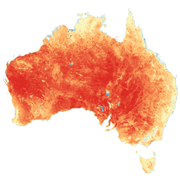
Soil and Landscape Grid of Australia (SLGA) เป็นชุดข้อมูลที่ครอบคลุมเกี่ยวกับคุณลักษณะของดินทั่วออสเตรเลียที่ความละเอียด 3 อาร์ควินาที (~90 ม. พิกเซล) พื้นผิวคือผลลัพธ์จากการสร้างแบบจำลองที่อธิบายการกระจายเชิงพื้นที่ของแอตทริบิวต์ดินโดยใช้ข้อมูลดินที่มีอยู่และสิ่งแวดล้อม …
[[["เข้าใจง่าย","easyToUnderstand","thumb-up"],["แก้ปัญหาของฉันได้","solvedMyProblem","thumb-up"],["อื่นๆ","otherUp","thumb-up"]],[["ไม่มีข้อมูลที่ฉันต้องการ","missingTheInformationINeed","thumb-down"],["ซับซ้อนเกินไป/มีหลายขั้นตอนมากเกินไป","tooComplicatedTooManySteps","thumb-down"],["ล้าสมัย","outOfDate","thumb-down"],["ปัญหาเกี่ยวกับการแปล","translationIssue","thumb-down"],["ตัวอย่าง/ปัญหาเกี่ยวกับโค้ด","samplesCodeIssue","thumb-down"],["อื่นๆ","otherDown","thumb-down"]],[],[],["Several datasets provide detailed geographic and environmental information about Australia. Digital Elevation Models (DEMs) include a 5-meter grid from LiDAR surveys, a hydrologically enforced model, and a smoothed model from SRTM data, as well as a national intertidal DEM. Additional data includes the Soil and Landscape Grid of Australia (SLGA) with soil attributes. Landsat data is processed to show actual evapotranspiration (AET), land cover, water observations, and statistical analysis.\n"]]