美國國家科學基金會的國家生態觀測網 (NEON) 是由 Battelle 營運的大陸規模觀測機構,旨在收集長期開放存取的生態資料,進一步瞭解美國生態系統的變化。除了原位資料產品外,NEON 還在美國和波多黎各境內 81 個陸地和水生田野地點,提供重複的高解析度空載遙測資料,供生態研究和監測使用。
-
NEON 樹冠高度模型 (CHM)

樹冠頂端高於裸露地面的高度 (樹冠高度模型;CHM)。CHM 是從 NEON LiDAR 點雲衍生而來,方法是在 LiDAR 測繪的整個空間網域中,建立連續的樹冠高度估計值表面。… airborne canopy forest forest-biomass lidar neon -
NEON 數位高程模型 (DEM)

從 NEON LiDAR 資料衍生的地表 (DSM) 和地形 (DTM) 數位模型。DSM:地表特徵 (包含植被和人造結構的地形資訊)。DTM:裸露地表高程 (移除植被和人造結構的地形資訊)。圖片以高於平均海平面幾公尺為單位,… airborne dem elevation-topography forest lidar neon -
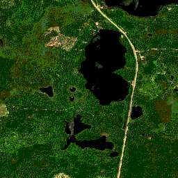
NEON RGB 攝影機影像

高解析度紅綠藍 (RGB) 正射校正相機影像,使用最鄰近插值法拼接並輸出至固定、均勻的空間格線;空間解析度為 0.1 公尺。這部數位相機是 NEON 空中觀測平台 (AOP) 的一系列儀器之一,其他儀器還包括… airborne forest highres neon neon-prod-earthengine orthophoto -
NEON Surface Bidirectional Reflectance
NEON AOP Surface Bidirectional Reflectance 是超光譜 VSWIR (可見光到短波紅外線) 資料產品,包含 426 個波段,波長範圍約為 380 nm 到 2510 nm。反射率會以 10000 的因數縮放。波長介於 1340 到 1445 奈米和 1790 到 1955 奈米之間,設定為 … airborne forest hyperspectral neon neon-prod-earthengine publisher-dataset -
NEON Surface Directional Reflectance

NEON AOP Surface Directional Reflectance 是超光譜 VSWIR (可見光至短波紅外線) 資料產品,包含 426 個波段,波長範圍約為 380 nm 至 2510 nm。反射率會以 10000 的因數縮放。波長介於 1340 到 1445 奈米和 1790 到 1955 奈米之間,設定為 … airborne forest hyperspectral neon neon-prod-earthengine publisher-dataset