

- مالك الكتالوج
- Awesome GEE Community Catalog
- توفُّر مجموعة البيانات
- 2000-01-04T00:00:00Z–2026-10-13T00:00:00Z
- Dataset Producer
- المركز الوطني للتخفيف من آثار الجفاف
- العلامات
الوصف
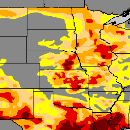
"مرصد الجفاف في الولايات المتحدة" هو خريطة يتم إصدارها كل يوم خميس، وتُظهر أجزاء من الولايات المتحدة التي تعاني من الجفاف. تستخدم الخريطة خمسة تصنيفات: جفاف غير طبيعي (D0)، يعرض المناطق التي قد تدخل في حالة جفاف أو تخرج منها، وأربعة مستويات من الجفاف: معتدل (D1)، وشديد (D2)، وقاسٍ (D3)، واستثنائي (D4). منذ إطلاق "مرصد الجفاف" في عام 1999، وهو ثمرة جهد جماعي مشترك بين "المركز الوطني للتخفيف من آثار الجفاف" (NDMC) في جامعة نبراسكا لينكولن، و"الإدارة الوطنية للمحيطات والغلاف الجوي" (NOAA)، و"وزارة الزراعة الأمريكية" (USDA). يستضيف "المركز الوطني للتخفيف من آثار الجفاف" (NDMC) الموقع الإلكتروني لبرنامج "مراقبة الجفاف" والبيانات المرتبطة به، ويقدّم الخريطة والبيانات إلى "الإدارة الوطنية للمحيطات والغلاف الجوي" (NOAA) و"وزارة الزراعة الأمريكية" (USDA) ووكالات أخرى. وهي متاحة مجانًا على الموقع الإلكتروني droughtmonitor.unl.edu.
النطاقات
النطاقات
حجم البكسل: 250 مترًا (جميع النطاقات)
| الاسم | الحد الأدنى | الحد الأقصى | حجم البكسل | الوصف |
|---|---|---|---|---|
DM |
0 | 4 | 250 متر | فئات الجفاف |
بنود الاستخدام
بنود الاستخدام
العمل مرخَّص بموجب ترخيص بيانات مفتوحة للاستخدام. يتم إنتاج "مرصد الجفاف في الولايات المتحدة" (U.S. Drought Monitor) بشكل مشترك من قِبل "المركز الوطني للتخفيف من آثار الجفاف" (National Drought Mitigation Center) في جامعة نبراسكا لينكولن و"وزارة الزراعة الأمريكية" (United States Department of Agriculture) و"الإدارة الوطنية للمحيطات والغلاف الجوي" (National Oceanic and Atmospheric Administration). الخريطة مقدَّمة من NDMC.
الاقتباسات
المركز الوطني للتخفيف من آثار الجفاف، وزارة الزراعة الأمريكية، الإدارة الوطنية للمحيطات والغلاف الجوي (2023). United States Drought Monitor جامعة نبراسكا لينكولن. https://droughtmonitor.unl.edu/. تاريخ الاطّلاع: 17-09-2023
الاستكشاف باستخدام Earth Engine
أداة تعديل الرموز (JavaScript)
var usdm = ee.ImageCollection(
  "projects/sat-io/open-datasets/us-drought-monitor"
);
/*
Category	Description
DO	Abnormally Dry
D1	Moderate Drought
D2	Severe Drought
D3	Extreme Drought
D4	Exceptional Drought
*/

var usdm = ee.Image(usdm.toList(usdm.size()).get(-1));

// Define a dictionary which will be used to make legend and visualize image on map
var dict = {
  names: [
    "DO	Abnormally Dry", //1
    "D1 Moderate Drought", //2
    "D2 Severe Drought", //3
    "D3 Extreme Drought", //4
    "D4 Exceptional Drought", //5
  ],
  colors: ["FFFF00", "FCD37F", "FFAA00", "E60000", "730000"],
};

// Create a panel to hold the legend widget
var legend = ui.Panel({
  style: {
    position: "bottom-left",
    padding: "8px 15px",
  },
});

// Function to generate the legend
function addCategoricalLegend(panel, dict, title) {
  // Create and add the legend title.
  var legendTitle = ui.Label({
    value: title,
    style: {
      fontWeight: "bold",
      fontSize: "18px",
      margin: "0 0 4px 0",
      padding: "0",
    },
  });
  panel.add(legendTitle);

  var loading = ui.Label("Loading legend...", { margin: "2px 0 4px 0" });
  panel.add(loading);

  // Creates and styles 1 row of the legend.
  var makeRow = function (color, name) {
    // Create the label that is actually the colored box.
    var colorBox = ui.Label({
      style: {
        backgroundColor: color,
        // Use padding to give the box height and width.
        padding: "8px",
        margin: "0 0 4px 0",
      },
    });

    // Create the label filled with the description text.
    var description = ui.Label({
      value: name,
      style: { margin: "0 0 4px 6px" },
    });

    return ui.Panel({
      widgets: [colorBox, description],
      layout: ui.Panel.Layout.Flow("horizontal"),
    });
  };

  // Get the list of palette colors and class names from the image.
  var palette = dict["colors"];
  var names = dict["names"];
  loading.style().set("shown", false);

  for (var i = 0; i < names.length; i++) {
    panel.add(makeRow(palette[i], names[i]));
  }

  Map.add(panel);
}

/*
  // Display map and legend ///////////////////////////////////////////////////////////////////////////////
*/

// Add the legend to the map
addCategoricalLegend(legend, dict, "US Drought Monitor");

// Add USDM Image image to the map
Map.addLayer(
  usdm,
  { min: 0, max: 4, palette: dict["colors"] },
  usdm.get("system:index").getInfo()
);