- Catalog Owner
- Forest Data Partnership
- Dataset Availability
- 2020-01-01T00:00:00Z–2024-12-31T23:59:59Z
- Dataset Producer
- Produced by Google for the Forest Data Partnership
- Tags
Description
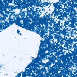
This image collection provides estimated per-pixel probability that the underlying area is occupied by the commodity. The probability estimates are provided at 10 meter resolution, and have been generated by a machine learning model. For details, see the technical documentation on the Forest Data Partnership repo on Github.
The primary purpose of this image collection is to support the mission of the Forest Data Partnership which aims to halt and reverse forest loss from commodity production by collaboratively improving global monitoring, supply chain tracking, and restoration.
This dataset currently covers the pan-tropical region (-24 to 24 degrees latitude).
This community data product is meant to evolve over time, as more data becomes available from the community and the model used to produce the maps continuously improves. If you would like to provide general feedback or additional datasets to improve these layers, please reach out through this form.
Please see this GitHub README for technical documentation and limitations of this dataset.
The difference between the 2025a and 2025b versions is that the 2025b version is based on AlphaEarth Foundations Satellite Embeddings, which enables expanded geographic and temporal coverage over 2025a. Additionally, 2025b includes additional input data and an evolved input data processing pipeline. Note that the 2025a model may perform better in some contexts.
Bands
Bands
Pixel size: 10 meters (all bands)
| Name | Min | Max | Pixel Size | Description |
|---|---|---|---|---|
probability |
0 | 1 | 10 meters | Probability that the pixel includes cocoa trees for the given year. |
Terms of Use
Terms of Use
Use of the dataset is subject to the CC-BY 4.0 license and requires the following attribution: "Produced by Google for the Forest Data Partnership".
Citations
Forest Data Partnership. 2026. Community models 2025b. Online
Explore with Earth Engine
Code Editor (JavaScript)
Map.setCenter(-7.67, 6.71, 11);

var collection = ee.ImageCollection(
  'projects/forestdatapartnership/assets/cocoa/model_2025b');

var cocoa2020 = collection.filterDate('2020-01-01', '2020-12-31').mosaic();
Map.addLayer(
  cocoa2020.selfMask(), {min: 0.48, max: 1, palette: 'white,blue'}, 'cocoa 2020');

var cocoa2024 = collection.filterDate('2024-01-01', '2024-12-31').mosaic();
Map.addLayer(
  cocoa2024.selfMask(), {min: 0.48, max: 1, palette: 'white,green'}, 'cocoa 2024');