geoBoundaries Global Database of Political Administrative Boundaries Database는 전 세계 모든 국가의 경계 (예: 주, 카운티)에 관한 온라인 오픈 라이선스 리소스입니다. 현재 195개의 모든 UN 회원국, 그린란드, 타이완, 니우에, 코소보를 포함하여 총 199개의 법인이 추적됩니다.
Comprehensive Global Administrative Zones (CGAZ)은 관리 경계의 전역 컴포지트 집합입니다. 분쟁 지역이 삭제되고 미국 국무부 정의에 따라 다각형으로 대체됩니다. 경계 수준이 ADM0, ADM1, ADM2의 세 가지이며, 국제 경계 (미국 국무부)에 맞게 잘려 있고 경계 사이의 간격이 채워져 있습니다.
이 데이터 세트는 CGAZ의 일부입니다. DBF_DATE_LAST_UPDATE=2023-09-13인 글로벌 컴포지트 파일의 버전 6.0.0에서 수집되었습니다.
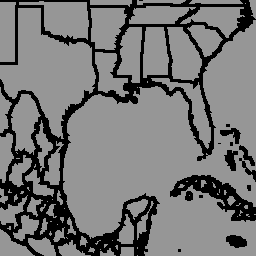
ADM1 (지역 수준 경계)의 경계를 보여줍니다.
표 스키마
표 스키마
이름
유형
설명
shapeGroup
문자열
고유 국가 코드
shapeName
문자열
행정 지역 이름
shapeType
문자열
경계 유형:
ADM0: 국가 수준
ADM1: 지역 수준
ADM2: 시/군/구 수준
shapeID
DOUBLE
모양에 할당된 고유 ID
이용약관
이용약관
geoBoundaries 데이터 세트는 CC BY 4.0 라이선스에 따라 제공되며, 이 라이선스는 대부분의 상업적, 비상업적, 학술적 용도를 허용합니다. 제공업체 이용약관을 참고하세요.
geoBoundaries Global Database of Political Administrative Boundaries Database는 전 세계 모든 국가의 경계 (예: 주, 카운티)에 관한 온라인 오픈 라이선스 리소스입니다. 현재 195개 UN 회원국, 그린란드, 타이완, 니우에, 코소보를 포함한 총 199개 항목이 추적됩니다. Comprehensive Global Administrative Zones (CGAZ)는 …
[[["이해하기 쉬움","easyToUnderstand","thumb-up"],["문제가 해결됨","solvedMyProblem","thumb-up"],["기타","otherUp","thumb-up"]],[["필요한 정보가 없음","missingTheInformationINeed","thumb-down"],["너무 복잡함/단계 수가 너무 많음","tooComplicatedTooManySteps","thumb-down"],["오래됨","outOfDate","thumb-down"],["번역 문제","translationIssue","thumb-down"],["샘플/코드 문제","samplesCodeIssue","thumb-down"],["기타","otherDown","thumb-down"]],[],[],["The geoBoundaries database, provided by William and Mary geoLab, offers open-license administrative boundaries for 199 global entities, including UN member states. This dataset, part of Comprehensive Global Administrative Zones (CGAZ), is version 6.0.0, last updated on 2023-09-13. It features ADM1 (district-level) boundaries with data available on Earth Engine via `ee.FeatureCollection(\"WM/geoLab/geoBoundaries/600/ADM1\")`. Data can be visualized with `ui.Map.FeatureViewLayer`, and the terms of use allow for commercial, noncommercial, and academic usage under the CC BY 4.0 license.\n"]]