- 利用可能なデータセットの期間
- 2007-01-01T00:00:00Z–2026-06-22T00:00:00Z
- データセット プロデューサー
- 東京大学 生産技術研究所(日本)
- ケイデンス
- 1 日
- タグ
説明
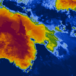
Keetch-Byram Drought Index(KBDI)は、土壌とダフ層の乾燥度を推定するための連続的な基準スケールです。雨が降らない日が続くほど指数は上昇し(上昇幅は日中の最高気温によって異なります)、雨が降ると指数は低下します。このシステムは、主に最近の降雨パターンに基づいています。気象干ばつの指標であり、土壌内の水分量の増減を反映しています。
スケールは 0(水分不足なし)から 800(極度の干ばつ)の範囲です。指標の範囲は、植生が容易に利用できる飽和土壌に 20 cm の水分があると仮定して決定されます(Keetch と Byram、1968 年)。KBDI は、全国の天気予報、山火事の防止、特に雨水に依存する作物の栽培地域での干ばつ監視に世界中で広く使用されています。
バンド
バンド
ピクセルサイズ: 4,000 メートル(すべてのバンド)
| 名前 | 最小 | 最大 | ピクセルサイズ | 説明 |
|---|---|---|---|---|
KBDI |
0 | 800 | 4,000 メートル | Keetch-Byram 渇水指数 |
利用規約
利用規約
引用
引用:
Wataru Takeuchi, Soni Darmawan, Rizatus Shofiyati, Mai Van Khiem, Kyaw San Oo, Uday Pimple and Suthy Heng, 2015. アジアの農地におけるほぼリアルタイムの気象干ばつモニタリングと早期警戒システム。第 36 回アジアリモートセンシング会議(ACRS): フィリピン、マニラ、2015 年 10 月 20 日。
Earth Engine で探索する
コードエディタ(JavaScript)
var collection = ee.ImageCollection('UTOKYO/WTLAB/KBDI/v1')
  .select('KBDI')
  .filterDate('2019-01-01', '2019-01-10');
var bandViz = {
  min: 0,
  max: 800,
  palette: [
    '001a4d', '003cb3', '80aaff', '336600', 'cccc00', 'cc9900', 'cc6600',
    '660033'
  ]
};
Map.addLayer(collection.mean(), bandViz, 'Keetch-Byram Drought Index');
Map.setCenter(120, 3, 3);