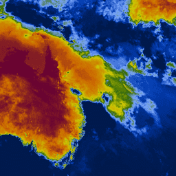
키치-바이람 가뭄 지수 (KBDI)는 토양 및 썩은 잎층의 건조도를 추정하기 위한 연속 참조 척도입니다. 이 지수는 비가 오지 않는 날마다 증가하며 (증가량은 일일 최고 기온에 따라 다름) 비가 오면 감소합니다. 이 시스템은 주로 최근 강우 패턴을 기반으로 합니다. 기상 가뭄을 측정하는 것으로, 토양 내 수분 증가 또는 손실을 반영합니다.
척도는 0 (수분 부족 없음)에서 800 (극심한 가뭄)까지입니다. 지수의 범위는 식물이 쉽게 이용할 수 있는 포화 토양에 20cm의 수분이 있다고 가정하여 결정됩니다 (Keetch 및 Byram, 1968). KBDI는 국가 일기 예보, 산불 예방, 특히 강우에 의존하는 작물이 있는 지역에서 유용하게 사용되는 가뭄 모니터링에 전 세계적으로 사용됩니다.
Wataru Takeuchi, Soni Darmawan, Rizatus Shofiyati, Mai Van Khiem, Kyaw San Oo, Uday Pimple, Suthy Heng, 2015. 아시아 농경지의 거의 실시간 기상 가뭄 모니터링 및 조기 경보 시스템.
제36회 아시아 원격 감지 컨퍼런스 (ACRS): 필리핀 마닐라, 2015년 10월 20일.
[[["이해하기 쉬움","easyToUnderstand","thumb-up"],["문제가 해결됨","solvedMyProblem","thumb-up"],["기타","otherUp","thumb-up"]],[["필요한 정보가 없음","missingTheInformationINeed","thumb-down"],["너무 복잡함/단계 수가 너무 많음","tooComplicatedTooManySteps","thumb-down"],["오래됨","outOfDate","thumb-down"],["번역 문제","translationIssue","thumb-down"],["샘플/코드 문제","samplesCodeIssue","thumb-down"],["기타","otherDown","thumb-down"]],[],[],["The dataset provides the Keetch-Byram Drought Index (KBDI), a measure of soil and duff layer dryness, ranging from 0 (no deficit) to 800 (extreme drought). The index increases during dry periods and decreases with rainfall, reflecting meteorological drought conditions. The data, provided by the University of Tokyo, is updated daily from 2007-01-01 to 2025-02-21 and is available via Google Earth Engine. Pixel size is 4000 meters. It is tagged for drought and rainfall.\n"]]