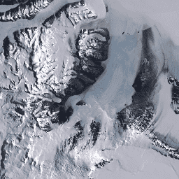
Bindschadler, R.、Vornberger, P.、Fleming, A.、Fox, A.、Mullins, J.、
Binnie, D.、Paulson, S.、Granneman, B., and Gorodetzky, D., 2008,
The Landsat Image Mosaic of Antarctica, Remote Sensing of
Environment, 112, pp. 4214-4226.
PDF
[[["容易理解","easyToUnderstand","thumb-up"],["確實解決了我的問題","solvedMyProblem","thumb-up"],["其他","otherUp","thumb-up"]],[["缺少我需要的資訊","missingTheInformationINeed","thumb-down"],["過於複雜/步驟過多","tooComplicatedTooManySteps","thumb-down"],["過時","outOfDate","thumb-down"],["翻譯問題","translationIssue","thumb-down"],["示例/程式碼問題","samplesCodeIssue","thumb-down"],["其他","otherDown","thumb-down"]],[],[],["The Landsat Image Mosaic of Antarctica (LIMA) dataset, provided by USGS, spans from June 30, 1999, to September 4, 2002. It's a cloudless mosaic of processed Landsat 7 ETM+ scenes, using pan-sharpened normalized surface reflectance data. The mosaic was created by layering cloud-free images and adjusting boundaries. Data, available in 15-meter pixel size, is accessible via Earth Engine using the snippet `ee.Image(\"USGS/LIMA/MOSAIC\")`, and users can explore tile footprints at `USGS/LIMA/MOSAIC_TILE_FOOTPRINTS`.\n"]]