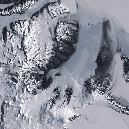
Landsat Image Mosaic of Antarctica (LIMA)는 처리된 Landsat 7 ETM+ 장면에서 생성된 원활하고 사실상 구름이 없는 모자이크입니다.
이 LIMA 데이터 세트는 16비트 중간 LIMA입니다.
모자이크는 팬샤프닝된 정규화된 표면 반사율 장면 (Landsat ETM+ 밴드 1, 2, 3, 4)으로 구성됩니다. 모자이크는 클라우드 없는 이미지를 맨 위에 배치하고 타일 불연속이 발생할 때 이미지 경계를 잘라 구성되었습니다.
이 이미지는 퍼블릭 도메인에 속하며 출처 표시 없이 자유롭게 사용할 수 있습니다. 하지만 Landsat Image Mosaic of Antarctica (LIMA) 프로젝트에 대한 출처 표시는 대단히 감사드립니다.
인용
인용:
Bindschadler, R., Vornberger, P., Fleming, A., Fox, A., Mullins, J.,
Binnie, D., Paulson, S., Granneman, B., and Gorodetzky, D., 2008,
The Landsat Image Mosaic of Antarctica, Remote Sensing of
Environment, 112, pp. 4214-4226.
PDF
남극의 Landsat 이미지 모자이크 (LIMA)는 처리된 Landsat 7 ETM+ 장면에서 생성된 매끄럽고 사실상 구름이 없는 모자이크입니다. 이 LIMA 데이터 세트는 16비트 중간 LIMA입니다. 모자이크는 팬샤픈된 정규화된 표면 반사율 장면 (Landsat ETM+ 밴드 1, 2, 3, 4)으로 구성됩니다. 모자이크는 …
[[["이해하기 쉬움","easyToUnderstand","thumb-up"],["문제가 해결됨","solvedMyProblem","thumb-up"],["기타","otherUp","thumb-up"]],[["필요한 정보가 없음","missingTheInformationINeed","thumb-down"],["너무 복잡함/단계 수가 너무 많음","tooComplicatedTooManySteps","thumb-down"],["오래됨","outOfDate","thumb-down"],["번역 문제","translationIssue","thumb-down"],["샘플/코드 문제","samplesCodeIssue","thumb-down"],["기타","otherDown","thumb-down"]],[],[],["The Landsat Image Mosaic of Antarctica (LIMA) dataset, provided by USGS, spans from June 30, 1999, to September 4, 2002. It's a cloudless mosaic of processed Landsat 7 ETM+ scenes, using pan-sharpened normalized surface reflectance data. The mosaic was created by layering cloud-free images and adjusting boundaries. Data, available in 15-meter pixel size, is accessible via Earth Engine using the snippet `ee.Image(\"USGS/LIMA/MOSAIC\")`, and users can explore tile footprints at `USGS/LIMA/MOSAIC_TILE_FOOTPRINTS`.\n"]]