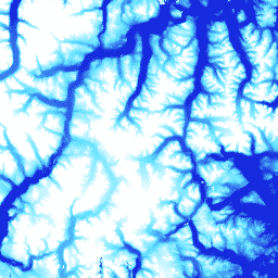
ArcticDEM は、植生、樹冠、建物、その他の人工的な地表の形状を含む、初回反射の標高値を表す数値表層モデル(DSM)です。2 m アセットは、ストリップ間の投影の違いにより、単一のモザイクではなくストリップのコレクションです。
モザイク DEM ファイルは、最良品質のストリップ DEM ファイルからコンパイルされます。これらのファイルは、空白領域とエッジ マッチング アーティファクトを減らすためにブレンドされ、フェザリングされています。フィルタリングされた IceSAT 高度計データがラスター ファイルに適用され、絶対精度が向上しています。
バンド
バンド
ピクセルサイズ: 5 メートル(すべてのバンド)
名前
単位
最小
最大
ピクセルサイズ
説明
elevation
m
-416.45*
5,971.24*
5 メートル
高度
matchtag
5 メートル
ステレオ マッチングから導出された DEM ピクセル(1)または補間された DEM ピクセル(0)を示すビットマスク ラスタ
[[["わかりやすい","easyToUnderstand","thumb-up"],["問題の解決に役立った","solvedMyProblem","thumb-up"],["その他","otherUp","thumb-up"]],[["必要な情報がない","missingTheInformationINeed","thumb-down"],["複雑すぎる / 手順が多すぎる","tooComplicatedTooManySteps","thumb-down"],["最新ではない","outOfDate","thumb-down"],["翻訳に関する問題","translationIssue","thumb-down"],["サンプル / コードに問題がある","samplesCodeIssue","thumb-down"],["その他","otherDown","thumb-down"]],[],[],["This document details the ArcticDEM V2 5m dataset, a digital surface model from the University of Minnesota Polar Geospatial Center. It provides 5-meter resolution elevation data, including vegetation and man-made features, from imagery taken on September 21, 2016. The data includes elevation, and a match tag indicating if the pixel was derived from a stereo match or interpolation. The data must be cited when used, and is accessible through Google Earth Engine, which requires registration.\n"]]