- Dataset Availability
- 2016-04-14T00:00:00Z–2026-06-13T10:16:36Z
- Dataset Producer
- NASA JPL
- Cadence
- 1 Day
- Tags
Description
This product consists of radar backscatter normalized with respect to the topography. It maps signals related to the physical properties of ground scattering objects, such as surface roughness and soil moisture and/or vegetation. The OPERA RTC-S1 product is derived from Copernicus Sentinel-1 Interferometric Wide (IW) Single Look Complex (SLC) data with a near global scope and temporal sampling coincident with the availability of SLC data.
Each OPERA RTC-S1 product corresponds to a single S1 burst projected onto a pre-defined UTM/Polar stereographic map projection system map grid with a 30-meter spacing. The Copernicus global 30 m (GLO-30) Digital Elevation Model (DEM) is the reference DEM used to correct for the impacts of topography and to geocode the product. The OPERA RTC-S1 product is normalized to the backscatter coefficient gamma0 obtained from the original radar brightness beta0 through radiometric terrain correction.
Due to the S1 mission’s narrow orbital tube, radar-geometry layers such as incidence angle, local incidence angle, number of looks, and RTC Area Normalization Factor (ANF) vary slightly over time for each position on the ground, and therefore are considered static. These static layers are provided separately from the OPERA RTC-S1 product, as they are produced only once or a limited number of times, to account for changes in the DEM, in the S1 orbit, or in the static-layers generation algorithm. The static layers are available in the associated OPERA Radiometric Terrain Corrected SAR Backscatter from Sentinel-1 Static Layers dataset.
Bands
Bands
Pixel size: 30 meters (all bands)
| Name | Pixel Size | Description |
|---|---|---|
VV |
30 meters | VV polarization radar backscatter normalized to gamma0. |
VH |
30 meters | VH polarization radar backscatter normalized to gamma0. |
HV |
30 meters | HV polarization radar backscatter normalized to gamma0. |
HH |
30 meters | HH polarization radar backscatter normalized to gamma0. |
mask |
30 meters | Mask layer containing valid/invalid, layover, and shadow classification computed using the RTC-S1 burst orbit, provided over the same geographic grid as the associated geocoded imagery. |
mask Class Table
| Value | Color | Description |
|---|---|---|
| 0 | #000000 | Valid sample not affected by layover or shadow |
| 1 | #FF0000 | Valid sample affected by shadow |
| 2 | #00FF00 | Valid sample affected by layover |
| 3 | #FFFF00 | Valid sample affected by layover and shadow |
| 255 | #FFFFFF | Invalid sample |
Image Properties
Image Properties
| Name | Type | Description |
|---|---|---|
| ABSOLUTE_ORBIT_NUMBER | DOUBLE | Absolute orbit number |
| ACQUISITION_MODE | STRING | Acquisition mode |
| BURST_ID | STRING | Burst identification string |
| INPUT_L1_SLC_GRANULES | STRING_LIST | List of input L1 SLC granules |
| INPUT_ORBIT_FILES | STRING_LIST | List of input orbit files |
| INSTRUMENT_NAME | STRING | Name of the instrument used to collect the remote sensing data provided in this product |
| LOOK_DIRECTION | STRING | Look direction |
| ORBIT_PASS_DIRECTION | STRING | Orbit pass direction |
| POLARIZATIONS | STRING_LIST | The polarization bands available in the asset, a list with the valid values being: "VV", "VH", "HV" and "HH". |
| PROCESSING_DATETIME | STRING | Product generation time in UTC. Format: YYYY-MM-DDTHH:MM:SSZ |
| PROCESSING_TYPE | STRING | Processing type. One of: "NOMINAL", "URGENT", "CUSTOM", or "UNDEFINED" |
| PRODUCT_VERSION | STRING | Product version |
| QA_GEOMETRIC_ACCURACY_BIAS_X | DOUBLE | An estimate of the localization error bias in the easting direction' |
| QA_GEOMETRIC_ACCURACY_BIAS_Y | DOUBLE | An estimate of the localization error bias in the northing direction' |
| QA_GEOMETRIC_ACCURACY_STDDEV_X | DOUBLE | An estimate of the localization error standard deviation in the easting direction |
| QA_GEOMETRIC_ACCURACY_STDDEV_Y | DOUBLE | An estimate of the localization error standard deviation in the northing direction |
| SUB_SWATH_ID | STRING | Sub-swath identifier |
| TRACK_NUMBER | DOUBLE | Track number |
Terms of Use
Terms of Use
This dataset is openly shared, without restriction, in accordance with the EOSDIS Data Use and Citation Guidance
Citations
NASA/JPL/OPERA. (2023). OPERA Radiometric Terrain Corrected SAR Backscatter from Sentinel-1 validated product (Version 1) [Data set]. NASA Alaska Satellite Facility Distributed Active Archive Center. doi:10.5067/SNWG/OPERA_L2_RTC-S1_V1
DOIs
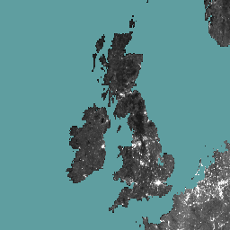
Explore with Earth Engine
Code Editor (JavaScript)
var geometry = ee.Geometry.BBox(-18, 49, 8, 60);
var waterLandMask =
    ee.Image('NOAA/NGDC/ETOPO1').select('bedrock').gte(0.0).clip(geometry);

var rtc_s1 = ee.ImageCollection('OPERA/RTC/L2_V1/S1')
                 .filterDate('2025-10-25', '2025-11-01')
                 .filterBounds(geometry)
                 .filter(ee.Filter.listContains('POLARIZATIONS', 'VV'))
                 .mean()
                 .mask(waterLandMask);

Map.centerObject(geometry);
Map.addLayer(rtc_s1.select('VV'), {min: 0, max: 0.5}, 'VV');