- 데이터 세트 제공
- 1979-01-01T00:00:00Z–2026-06-20T00:00:00Z
- 데이터 세트 출처
- NOAA 물리 과학 연구소
- 태그
설명
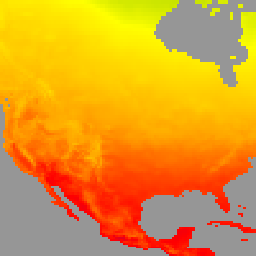
이 데이터 세트는 일일 최고 기온 (Tmax), 최저 기온 (Tmin)을 비롯해 전 세계 육지 지역의 일일 지표면 기온에 관한 그리드 분석을 제공합니다. 1979년부터 현재까지의 데이터는 CPC의 게이지 기반 전 세계 일일 강수량 분석 해상도에 맞춰 0.5도 위도/경도 그리드로 표시됩니다. 이 데이터 세트의 구성은 지형 효과를 고려합니다. 주요 목적은 기후 모니터링 및 예측 확인 활동을 지원하는 것입니다. 입력 데이터는 GTS (Global Telecommunication System) 일일 보고서의 CPC 보관 파일에서 가져오며, 전 세계 약 6,000~7,000개 지점의 Tmax 및 Tmin 데이터를 통합합니다.
기술 문서는 여기를 참고하세요.
대역
대역
픽셀 크기: 55,500m (모든 밴드)
| 이름 | 단위 | 최소 | 최대 | 픽셀 크기 | 설명 |
|---|---|---|---|---|---|
tmax |
°C | -89.84* | 66.03* | 55,500미터 | 일일 최고 온도 |
tmin |
°C | -97.92* | 54.26* | 55,500미터 | 일일 최저 기온 |
nmax |
0* | 7* | 55,500미터 | 최고 기온 보고 횟수 |
|
nmin |
0* | 7* | 55,500미터 | 최저 온도 보고 수 |
이용약관
이용약관
NOAA CPC 데이터 세트는 사용 또는 배포에 제한 없이 사용할 수 있습니다. NOAA PSL은 사용자가 적절한 출처 표시를 제공하고 해당되는 경우 NOAA PSL을 데이터 소스로 식별하도록 요청합니다.
Earth Engine으로 탐색
코드 편집기(JavaScript)
var dataset = ee.ImageCollection('NOAA/CPC/Temperature').filter(ee.Filter.date('2018-01-01', '2019-01-01'));
var temperature = dataset.select('tmax');
var temperatureVis = {
  min: -40,
  max: 50,
  palette: ['#ADD8E6', '#008000', '#FFFF00', '#FFA500', '#FF0000', '#800080'],
};
Map.setCenter(-104.8, 49.1, 3);
Map.addLayer(temperature, temperatureVis, 'NOAA CPC Temperature');