Page Summary
-
The dataset contains derived values for Leaf Area Index (LAI) and Fraction of Absorbed Photosynthetically Active Radiation (FAPAR) characterizing plant canopy and photosynthetic activity.
-
It is derived from the NOAA AVHRR Surface Reflectance product, gridded at 0.05° resolution, and available daily from 1981-06-24 to 2013-12-31.
-
The dataset covers global land surfaces but excludes bare or very sparsely vegetated areas, permanent ice/snow, wetlands, urban areas, or water bodies.
-
Known issues include inaccuracies in TIMEOFDAY, latitude, and longitude values.
-
The data is nonproprietary and publicly available for use without restrictions.
- Dataset Availability
- 1981-06-24T00:00:00Z–2013-12-31T00:00:00Z
- Dataset Producer
- NOAA
- Cadence
- 1 Day
- Tags
Description
The NOAA Climate Data Record (CDR) of AVHRR Leaf Area Index (LAI) and Fraction of Absorbed Photosynthetically Active Radiation (FAPAR) dataset contains derived values that characterize the canopy and photosynthetic activity of plants. This dataset is derived from the NOAA AVHRR Surface Reflectance product and is gridded at a resolution of 0.05° on a daily basis. The values are computed globally over land surfaces, but not over bare or very sparsely vegetated areas, permanent ice or snow, permanent wetland, urban areas, or water bodies.
Known issues with this dataset include:
TIMEOFDAY variable contains values that are too large by 1 day
Latitude values are not correctly associated with the center of the grid cell, error is < 0.002 degrees
Longitude values are not correctly associated with the center of the grid cell, error is < 0.02 degrees
See technical note from the data provider.
Provider's note: the orbital drift of N-19 (the last NOAA satellite carrying the AVHRR sensor) began to severely degrade the retrieved product quality. Therefore, VIIRS is now the primary sensor being used for these products from 2014-present.
Bands
Bands
Pixel size: 5566 meters (all bands)
| Name | Min | Max | Scale | Pixel Size | Description | ||||||||||||||||||||||||||||||||||||||||||||||||||||||||||||||||||||||||||||||||||||||||||||||
|---|---|---|---|---|---|---|---|---|---|---|---|---|---|---|---|---|---|---|---|---|---|---|---|---|---|---|---|---|---|---|---|---|---|---|---|---|---|---|---|---|---|---|---|---|---|---|---|---|---|---|---|---|---|---|---|---|---|---|---|---|---|---|---|---|---|---|---|---|---|---|---|---|---|---|---|---|---|---|---|---|---|---|---|---|---|---|---|---|---|---|---|---|---|---|---|---|---|---|---|
LAI |
0* | 6205* | 0.001 | 5566 meters | Leaf area index |
||||||||||||||||||||||||||||||||||||||||||||||||||||||||||||||||||||||||||||||||||||||||||||||
FAPAR |
0* | 896* | 0.001 | 5566 meters | Fraction of absorbed photosynthetic active radiation |
||||||||||||||||||||||||||||||||||||||||||||||||||||||||||||||||||||||||||||||||||||||||||||||
QA |
5566 meters | Quality control bit flags |
|||||||||||||||||||||||||||||||||||||||||||||||||||||||||||||||||||||||||||||||||||||||||||||||||
Image Properties
Image Properties
| Name | Type | Description |
|---|---|---|
| status | STRING | 'provisional' or 'permanent' |
Terms of Use
Terms of Use
The NOAA CDR Program's official distribution point for CDRs is NOAA's National Climatic Data Center which provides sustained, open access and active data management of the CDR packages and related information in keeping with the United States' open data policies and practices as described in the President's Memorandum on "Open Data Policy" and pursuant to the Executive Order of May 9, 2013, "Making Open and Machine Readable the New Default for Government Information". In line with these policies, the CDR data sets are nonproprietary, publicly available, and no restrictions are placed upon their use. For more information, see the Fair Use of NOAA's CDR Data Sets, Algorithms and Documentation pdf.
Citations
Martin Claverie, Eric Vermote, and NOAA CDR Program (2014): NOAA Climate Data Record (CDR) of Leaf Area Index (LAI) and Fraction of Absorbed Photosynthetically Active Radiation (FAPAR), Version 4. [indicate subset used]. NOAA National Climatic Data Center. doi:10.7289/V5M043BX
DOIs
Explore with Earth Engine
Code Editor (JavaScript)
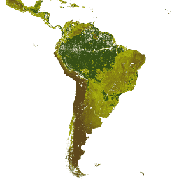
var dataset = ee.ImageCollection('NOAA/CDR/AVHRR/LAI_FAPAR/V5')
                  .filter(ee.Filter.date('2018-02-01', '2018-03-01'));
var leafAreaIndex = dataset.select('LAI');
var leafAreaIndexVis = {
  min: 0.0,
  max: 4000.0,
  palette: ['3b0200', '977705', 'ca9f06', 'ffca09', '006a03', '003b02'],
};
Map.setCenter(20, 24.5, 2);
Map.addLayer(leafAreaIndex, leafAreaIndexVis, 'Leaf Area Index');