- Dataset Availability
- 2012-01-17T00:00:00Z–2026-10-04T00:00:00Z
- Dataset Producer
- NASA LP DAAC at the USGS EROS Center
- Cadence
- 1 Day
- Tags
Description
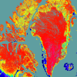
The NASA/NOAA Suomi National Polar-orbiting Partnership (Suomi NPP) Visible Infrared Imaging Radiometer Suite (VIIRS) Bidirectional Reflectance Distribution Function (BRDF) and Albedo (BRDF/Albedo) Version 2 product provides albedo estimates at 500 meter resolution. The VNP43IA3 product is produced daily using 16 days of VIIRS data and is weighted temporally to the ninth day, which is reflected in the file name. It provides both directional hemispherical reflectance (black-sky albedo) at local solar noon and bihemispherical reflectance (white-sky albedo) for the three VIIRS imagery bands (I1, I2, and I3). The VNP43 data products are designed to promote the continuity of NASA's Moderate Resolution Imaging Spectroradiometer (MODIS) BRDF/Albedo data product suite.
The VNP43 algorithm uses the RossThick/Li-Sparse-Reciprocal (RTLSR) semi-empirical kernel-driven BRDF model, with the three kernel weights from VNP43IA1 to reconstruct surface anisotropic effects, correcting the directional reflectance to a common view geometry (VNP43IA4), while also computing integrated black-sky albedo (BSA) at local solar noon and white-sky albedo (WSA) (VNP43IA3). Researchers can use the BRDF model parameters with a simple polynomial, to obtain black-sky albedo at any solar illumination angle. Likewise, both the BSA and WSA Science Dataset (SDS) layers can be used with a simple polynomial, to manually estimate instantaneous actual albedo (blue-sky albedo). Additional details regarding the methodology are available in the Algorithm Theoretical Basis Document (ATBD).
Documentation:
Bands
Bands
Pixel size: 500 meters (all bands)
| Name | Pixel Size | Description |
|---|---|---|
BRDF_Albedo_Band_Mandatory_Quality_I1 |
500 meters | BRDF/Albedo mandatory quality for band I1 |
BRDF_Albedo_Band_Mandatory_Quality_I2 |
500 meters | BRDF/Albedo mandatory quality for band I2 |
BRDF_Albedo_Band_Mandatory_Quality_I3 |
500 meters | BRDF/Albedo mandatory quality for band I3 |
Albedo_BSA_I1 |
500 meters | Black-sky albedo for band I1 |
Albedo_BSA_I2 |
500 meters | Black-sky albedo for band I2 |
Albedo_BSA_I3 |
500 meters | Black-sky albedo for band I3 |
Albedo_WSA_I1 |
500 meters | White-sky albedo for band I1 |
Albedo_WSA_I2 |
500 meters | White-sky albedo for band I2 |
Albedo_WSA_I3 |
500 meters | White-sky albedo for band I3 |
Terms of Use
Terms of Use
LP DAAC NASA data are freely accessible; however, when an author publishes these data or works based on the data, it is requested that the author cite the datasets within the text of the publication and include a reference to them in the reference list.
Citations
Schaaf, C., Z. Wang, A. Erb, I. Paynter. VIIRS/NPP BRDF/Albedo Albedo Daily L3 Global 500m SIN Grid V002. 2024, distributed by NASA EOSDIS Land Processes Distributed Active Archive Center, 10.5067/VIIRS/VNP43IA3.002.
DOIs
Explore with Earth Engine
Code Editor (JavaScript)
var dataset = ee.ImageCollection('NASA/VIIRS/002/VNP43IA3')
                  .filter(ee.Filter.date('2021-06-01', '2021-06-03'));

var blackSkyAlbedo = dataset.select('Albedo_BSA_I1').first();
var palette = [
  '000080',
  '0000d9',
  '4000ff',
  '8000ff',
  '0080ff',
  '00ffff',
  '00ff80',
  '80ff00',
  'daff00',
  'ffff00',
  'fff500',
  'ffda00',
  'ffb000',
  'ffa400',
  'ff4f00',
  'ff2500',
  'ff0a00',
  'ff00ff',
];
var visParams = {
  min: 0,
  max: 400,
  palette: palette,
};

// cadetblue
var background = ee.Image.rgb(95, 158, 160).visualize({min: 0, max: 255});
var image = blackSkyAlbedo.visualize(visParams);

var lon = -8;
var lat = 60;

Map.addLayer(background, {}, 'background');
Map.addLayer(image, {}, 'Black-Sky Albedo I1');
Map.setCenter(lon, lat, 3);