- Dataset Availability
- 2023-08-02T00:00:00Z–2025-09-16T00:00:00Z
- Dataset Producer
- NASA ASDC
- Tags
Description
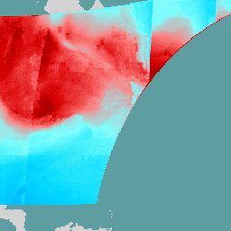
The TEMPO gridded ozone total column V03 (PROVISIONAL) is a Level 3 dataset providing essential total column ozone information on a regular grid across North America. Generated from the TEMPO instrument on the IS-40e platform, the data is created by combining and re-gridding Level 2 files from single East-West scan cycles using an area-weighted methodology. These measurements are critical for monitoring continental air quality and atmospheric chemistry and are distributed by the NASA Langley Research Center (LaRC) ASDC.
This Level 3 product serves as a quality-controlled version of the Level 2 data, pre-filtered to include only the highest-quality retrievals. Specifically, it includes pixels with a quality flag of 0, solar and viewing zenith angles (SZA/VZA) below 80°, and an effective cloud fraction under 0.5.
This dataset includes auxiliary measurements such as effective and radiative cloud properties, sulfur dioxide index, and terrain pressure. These parameters support a wide range of research applications while ensuring that users have access to research-ready data that has already been screened for common retrieval anomalies and extreme geometries.
Documentation:
Bands
Bands
Pixel size: 2226 meters (all bands)
| Name | Units | Pixel Size | Description |
|---|---|---|---|
relative_azimuth_angle |
deg | 2226 meters | Relative azimuth angle |
solar_zenith_angle |
deg | 2226 meters | Solar zenith angle |
viewing_zenith_angle |
deg | 2226 meters | Viewing zenith angle |
column_amount_o3 |
Dobson | 2226 meters | Total column ozone |
fc |
Dimensionless | 2226 meters | Effective cloud fraction (mixed LER model) |
o3_below_cloud |
Dobson | 2226 meters | Ozone concentration below cloud |
radiative_cloud_frac |
Dimensionless | 2226 meters | Radiative cloud fraction |
so2_index |
Dimensionless | 2226 meters | Sulfur dioxide index |
uv_aerosol_index |
Dimensionless | 2226 meters | UV aerosol index |
max_column_sample |
molecules/cm^2 | 2226 meters | Maximum column sample |
min_column_sample |
molecules/cm^2 | 2226 meters | Minimum column sample |
num_column_samples |
Dimensionless | 2226 meters | Number of column samples |
cloud_pressure |
hPa | 2226 meters | Cloud pressure |
terrain_height |
m | 2226 meters | Terrain height |
terrain_pressure |
hPa | 2226 meters | Terrain pressure |
weight |
km^2 | 2226 meters | Sum of Level 2 pixel overlap areas, representing the total spatial coverage of valid data within each grid cell. It serves as the weighting factor for calculating the gridded average, where lower values indicate partial coverage or data removed due to quality filtering. |
Terms of Use
Terms of Use
This dataset is in the public domain and is available without restriction on use and distribution. See NASA's Earth Science Data & Information Policy for additional information.
Citations
NASA/LARC/SD/ASDC.(2024). TEMPO gridded ozone total column V03 (PROVISIONAL) [Data set]. NASA Langley Atmospheric Science Data Center DAAC. Retrieved from 10.5067/IS-40e/TEMPO/O3TOT_L3.003
DOIs
Explore with Earth Engine
Code Editor (JavaScript)
var collection = ee.ImageCollection('NASA/TEMPO/O3_L3_QA')
    .filterDate('2024-04-01', '2024-04-05')

var visParams = {
  min: 0,
  max: 500,
  bands: ['column_amount_o3'],
  palette: [
    '000080', '0000D9', '4000FF', '8000FF', '0080FF',
    '00D9FF', '80FFFF', 'FF8080', 'D90000', '800000'
  ]
};
Map.setCenter(-95.06, 42.02, 3)
Map.addLayer(collection, visParams, 'Total Column Ozone')