Page Summary
-
The MODIS/MOD09GA_006_NDVI dataset provides the Normalized Difference Vegetation Index calculated from Near-IR and Red bands.
-
This dataset has a daily cadence and global coverage.
-
The dataset is available from 2000-02-24 to 2023-02-17 and is provided by Google.
-
There are no restrictions on the subsequent use, sale, or redistribution of this MODIS data and products.
- Dataset Availability
- 2000-02-24T00:00:00Z–2023-02-17T00:00:00Z
- Dataset Producer
- Cadence
- 1 Day
- Tags
Description
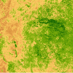
The Normalized Difference Vegetation Index is generated from the Near-IR and Red bands of each scene as (NIR - Red) / (NIR + Red), and ranges in value from -1.0 to 1.0. This product is generated from the MODIS/006/MOD09GA surface reflectance composites.
Bands
Bands
Pixel size: 463.313 meters (all bands)
| Name | Min | Max | Pixel Size | Description |
|---|---|---|---|---|
NDVI |
-1* | 1* | 463.313 meters | Normalized Difference Vegetation Index |
Terms of Use
Terms of Use
MODIS data and products acquired through the LP DAAC have no restrictions on subsequent use, sale, or redistribution.
Explore with Earth Engine
Code Editor (JavaScript)
var dataset = ee.ImageCollection('MODIS/MOD09GA_006_NDVI')
                  .filter(ee.Filter.date('2018-04-01', '2018-06-01'));
var colorized = dataset.select('NDVI');
var colorizedVis = {
  min: 0,
  max: 1,
  palette: [
    'ffffff', 'ce7e45', 'df923d', 'f1b555', 'fcd163', '99b718', '74a901',
    '66a000', '529400', '3e8601', '207401', '056201', '004c00', '023b01',
    '012e01', '011d01', '011301'
  ],
};
Map.setCenter(-7.03125, 31.0529339857, 2);
Map.addLayer(colorized, colorizedVis, 'Colorized');
import ee
import geemap.core as geemap
Colab (Python)
dataset = ee.ImageCollection('MODIS/MOD09GA_006_NDVI').filter(
    ee.Filter.date('2018-04-01', '2018-06-01')
)

colorized = dataset.select('NDVI')

colorized_vis = {
    'min': 0,
    'max': 1,
    'palette': [
        'ffffff', 'ce7e45', 'df923d', 'f1b555', 'fcd163', '99b718', '74a901',
        '66a000', '529400', '3e8601', '207401', '056201', '004c00', '023b01',
        '012e01', '011d01', '011301'
    ],
}

m = geemap.Map()
m.set_center(-7.03125, 31.0529339857, 2)
m.add_layer(colorized, colorized_vis, 'Colorized')
m