Page Summary
-
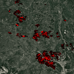
The MOD14A1 V6.1 dataset provides daily fire mask composites at 1km resolution from MODIS.
-
The fire detection method uses absolute and relative detection based on thermal radiances.
-
This dataset is used for monitoring the spatial and temporal distribution of fires globally.
-
Data is available from February 2000 to October 2025 and is updated daily.
-
No restrictions are placed on the subsequent use, sale, or redistribution of this data.
- Dataset Availability
- 2000-02-24T00:00:00Z–2026-07-03T00:00:00Z
- Dataset Producer
- NASA LP DAAC at the USGS EROS Center
- Cadence
- 1 Day
- Tags
Description
The MOD14A1 V6.1 dataset provides daily fire mask composites at 1km resolution derived from the MODIS 4- and 11-micrometer radiances. The fire detection strategy is based on absolute detection of a fire (when the fire strength is sufficient to detect), and on detection relative to its background (to account for variability of the surface temperature and reflection by sunlight). The product distinguishes between fire, no fire and no observation. This information is used for monitoring the spatial and temporal distribution of fires in different ecosystems, detecting changes in fire distribution and identifying new fire frontiers, wild fires, and changes in the frequency of the fires or their relative strength.
Documentation:
Bands
Bands
Pixel size: 1000 meters (all bands)
| Name | Units | Min | Max | Scale | Pixel Size | Description | |||||||||||||||||||||||||||||||||||||||||||||||||||||||||||||||||||||||||||||||||||||||||||||
|---|---|---|---|---|---|---|---|---|---|---|---|---|---|---|---|---|---|---|---|---|---|---|---|---|---|---|---|---|---|---|---|---|---|---|---|---|---|---|---|---|---|---|---|---|---|---|---|---|---|---|---|---|---|---|---|---|---|---|---|---|---|---|---|---|---|---|---|---|---|---|---|---|---|---|---|---|---|---|---|---|---|---|---|---|---|---|---|---|---|---|---|---|---|---|---|---|---|---|---|
FireMask |
1000 meters | Confidence of fire |
|||||||||||||||||||||||||||||||||||||||||||||||||||||||||||||||||||||||||||||||||||||||||||||||||
MaxFRP |
MW | 0 | 180000 | 0.1 | 1000 meters | Maximum fire radiative power |
|||||||||||||||||||||||||||||||||||||||||||||||||||||||||||||||||||||||||||||||||||||||||||||
sample |
0 | 1353 | 1000 meters | Position of fire pixel within scan |
|||||||||||||||||||||||||||||||||||||||||||||||||||||||||||||||||||||||||||||||||||||||||||||||
QA |
1000 meters | Pixel quality indicators |
|||||||||||||||||||||||||||||||||||||||||||||||||||||||||||||||||||||||||||||||||||||||||||||||||
Terms of Use
Terms of Use
MODIS data and products acquired through the LP DAAC have no restrictions on subsequent use, sale, or redistribution.
Citations
Please visit LP DAAC 'Citing Our Data' page for information on citing LP DAAC datasets.
DOIs
Explore with Earth Engine
Code Editor (JavaScript)
var dataset = ee.ImageCollection('MODIS/061/MOD14A1')
                  .filter(ee.Filter.date('2018-01-01', '2018-05-01'));
var fireMaskVis = {
  min: 0.0,
  max: 6000.0,
  bands: ['MaxFRP', 'FireMask', 'FireMask'],
};
Map.setCenter(6.746, 46.529, 2);
Map.addLayer(dataset, fireMaskVis, 'Fire Mask');