Page Summary
-
This dataset, providing global sub-pixel vegetation cover estimates, has been superseded by MODIS/061/MOD44B.
-
The dataset offers a continuous representation of Earth's terrestrial surface through percentages of tree cover, non-tree cover, and bare ground.
-
Generated yearly since 2000, this product is derived from monthly composites of Terra MODIS land surface reflectance and temperature data.
-
The dataset includes bands for percent tree cover, non-tree vegetation, and non-vegetated areas, along with quality and cloud information.
- Dataset Availability
- 2000-03-05T00:00:00Z–2023-07-31T00:00:00Z
- Dataset Producer
- NASA LP DAAC at the USGS EROS Center
- Cadence
- 1 Year
- Tags
Description
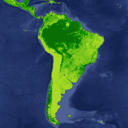
The Terra MODIS Vegetation Continuous Fields (VCF) product is a sub-pixel-level representation of surface vegetation cover estimates globally. Designed to continuously represent Earth's terrestrial surface as a proportion of basic vegetation traits, it provides a gradation of three surface cover components: percent tree cover, percent non-tree cover, and percent bare. VCF products provide a continuous, quantitative portrayal of land surface cover with improved spatial detail, and hence, are widely used in environmental modeling and monitoring applications.
Generated yearly, the VCF product is produced using monthly composites of Terra MODIS 250 and 500 meters Land Surface Reflectance data, including all seven bands, and Land Surface Temperature.
Documentation:
Bands
Bands
Pixel size: 250 meters (all bands)
| Name | Units | Min | Max | Scale | Pixel Size | Description | |||||||||||||||||||||||||||||||||||||||||||||||||||||||||||||||||||||||||||||||||||||||||||||
|---|---|---|---|---|---|---|---|---|---|---|---|---|---|---|---|---|---|---|---|---|---|---|---|---|---|---|---|---|---|---|---|---|---|---|---|---|---|---|---|---|---|---|---|---|---|---|---|---|---|---|---|---|---|---|---|---|---|---|---|---|---|---|---|---|---|---|---|---|---|---|---|---|---|---|---|---|---|---|---|---|---|---|---|---|---|---|---|---|---|---|---|---|---|---|---|---|---|---|---|
Percent_Tree_Cover |
% | 0 | 100 | 250 meters | Percent of a pixel which is covered by tree canopy |
||||||||||||||||||||||||||||||||||||||||||||||||||||||||||||||||||||||||||||||||||||||||||||||
Percent_NonTree_Vegetation |
% | 0 | 100 | 250 meters | Percent of a pixel which is covered by non-tree vegetation |
||||||||||||||||||||||||||||||||||||||||||||||||||||||||||||||||||||||||||||||||||||||||||||||
Percent_NonVegetated |
% | 0 | 100 | 250 meters | Percent of a pixel which is not vegetated |
||||||||||||||||||||||||||||||||||||||||||||||||||||||||||||||||||||||||||||||||||||||||||||||
Quality |
250 meters | Describes those inputs that had poor quality (cloudy, high aerosol, cloud shadow, or view zenith >45°). Each bit in the field represents 1 out of 8 input surface reflectance files to the model. |
|||||||||||||||||||||||||||||||||||||||||||||||||||||||||||||||||||||||||||||||||||||||||||||||||
Percent_Tree_Cover_SD |
% | 0 | 32767 | 0.01 | 250 meters | Standard deviation (SD) of the 30 models that were used to generate the pixel value in the percent tree cover data layer |
|||||||||||||||||||||||||||||||||||||||||||||||||||||||||||||||||||||||||||||||||||||||||||||
Percent_NonVegetated_SD |
% | 0 | 32767 | 0.01 | 250 meters | Standard deviation (SD) of the 30 models that were used to generate the pixel value in the percent non-vegetated data layer |
|||||||||||||||||||||||||||||||||||||||||||||||||||||||||||||||||||||||||||||||||||||||||||||
Cloud |
250 meters | Clarifies the 'Quality' layer to give the user an indication that the 'bad' data refers to cloudy input data. Each bit in the field represents 1 out of 8 input surface reflectance files to the model. |
|||||||||||||||||||||||||||||||||||||||||||||||||||||||||||||||||||||||||||||||||||||||||||||||||
Terms of Use
Terms of Use
MODIS data and products acquired through the LP DAAC have no restrictions on subsequent use, sale, or redistribution.
Citations
Please visit LP DAAC 'Citing Our Data' page for information on citing LP DAAC datasets.
Explore with Earth Engine
Code Editor (JavaScript)
var dataset = ee.ImageCollection('MODIS/006/MOD44B');

var visualization = {
  bands: ['Percent_Tree_Cover'],
  min: 0,
  max: 100,
  palette: ['bbe029', '0a9501', '074b03']
};

Map.setCenter(6.746, 46.529, 3);

Map.addLayer(dataset, visualization, 'Percent Tree Cover');