Google は AI 技術を使用して、コンテンツをご希望の言語に翻訳しています。AI 翻訳には誤りが含まれる場合があります。
フィードバックを送信
MCD15A3H.006 MODIS Leaf Area Index/FPAR 4-Day Global 500m [deprecated]
コレクションでコンテンツを整理
必要に応じて、コンテンツの保存と分類を行います。
利用可能なデータセットの期間
2002-07-04T00:00:00Z–2023-02-14T00:00:00Z
データセット プロデューサー
USGS EROS センターの NASA LP DAAC
Earth Engine スニペット
ee.ImageCollection("MODIS/006/MCD15A3H")
open_in_new
ケイデンス
4 日間
タグ
4-day(4 日間)
fpar
global
lai
mcd115a3h
modis
nasa
plant-productivity
usgs
樹木
説明
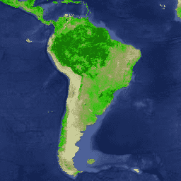
MCD15A3H V6 レベル 4、光合成有効放射(FPAR)と葉面積指数(LAI)の複合フラクション プロダクトは、500 メートルのピクセル サイズの 4 日間の複合データセットです。このアルゴリズムは、NASA の Terra 衛星と Aqua 衛星に搭載された両方の MODIS センサーが 4 日間の期間内に取得したすべてのデータから、利用可能な「最良」のピクセルを選択します。
ドキュメント:
バンド
バンド
ピクセルサイズ: 500 メートル(すべてのバンド)
名前
最小
最大
スケール
ピクセルサイズ
波長
説明
Fpar
0
100
0.01
500 メートル
400 ~ 700 nm
植生キャノピーの緑色の要素によって吸収される FPAR
Lai
0
100
0.1
500 メートル
なし
広葉樹の樹冠における単位面積あたりの片面の緑葉面積。針葉樹の樹冠における単位面積あたりの針葉の総表面積の半分
FparLai_QC
500 メートル
なし
Lai と Fpar の品質
FparLai_QC のビットマスク
ビット 0: MODLAND_QC ビット
0: 高品質(メイン アルゴリズム、彩度あり / なし)
1: その他の品質(バックアップ アルゴリズムまたは入力値)
ビット 1: センサー
ビット 2: デッド検出器
0: 検出器はチャンネル 1、2 の最大 50% で問題ないようです
1: 検出項目の停止により、隣接する検出項目の取得が 50% を超えた
ビット 3 ~ 4: 雲の状態
0: 雲がほとんどない(晴れ)
1: 重要な雲が「あった」
2: ピクセルに混合雲あり
3: クラウドの状態が定義されていない、クリアとみなされる
ビット 5 ~ 7: SCF_QC
0: 彩度なしで使用されるメイン(RT)メソッド。可能な限り最良の結果が得られます。
1: 彩度で使用されるメイン(RT)メソッド。良好で非常に使いやすい
2: ジオメトリが正しくないためメイン(RT)メソッドが失敗し、経験的アルゴリズムが使用されました
3: 幾何学以外の問題によりメイン(RT)メソッドが失敗したため、経験的アルゴリズムが使用されました
4: Google Pixel がまったく生成されず、値を取得できなかった(考えられる理由: L1B データが不良、MOD09GA データが使用不可)
FparExtra_QC
500 メートル
なし
LAI と FPAR の詳細品質の向上
FparExtra_QC のビットマスク
ビット 0 ~ 1: 陸海パススルー
0: LAND
1: SHORE
2: FRESHWATER
3: OCEAN
ビット 2: 雪氷
0: 雪氷は検出されませんでした
1: 雪氷が検出された
ビット 3: エアロゾル
0: 大気中のエアロゾル濃度が検出されなかったか、低い
1: エアロゾル レベルが平均または高いことが検出された
ビット 4: Cirrus
0: cirrus が検出されませんでした
1: 巻雲が検出されました
ビット 5: 内部の雲マスク
ビット 6: 雲の影
0: 雲の影が検出されませんでした
1: 雲の影が検出されました
ビット 7: SCF バイオーム マスク
0: 間隔 <1,4> の外側のバイオーム
1: 間隔 <1,4> のバイオーム
FparStdDev
0
100
0.01
500 メートル
なし
Fpar の標準偏差
LaiStdDev
0
100
0.1
500 メートル
なし
Lai の標準偏差
利用規約
利用規約
LP DAAC を通じて取得した MODIS データとプロダクトには、その後の使用、販売、再配布に関する制限はありません。
Earth Engine で探索する
重要:
Earth Engine は、公共の利益のため、および、ビジネス ユーザーや政府機関のユーザーのための、地理空間データセットのペタバイト規模の科学的分析と可視化を目的としたプラットフォームです。Earth Engine は、研究、教育、非営利目的の場合は無料でご使用いただけます。まず、Earth Engine への登録 を行ってください。
コードエディタ(JavaScript)
var dataset = ee . ImageCollection ( 'MODIS/006/MCD15A3H' );
var defaultVisualization = dataset . first (). select ( 'Fpar' );
var defaultVisualizationVis = {
min : 0.0 ,
max : 100.0 ,
palette : [ 'e1e4b4' , '999d60' , '2ec409' , '0a4b06' ],
};
Map . setCenter ( 6.746 , 46.529 , 6 );
Map . addLayer (
defaultVisualization , defaultVisualizationVis , 'Default visualization' );
コードエディタで開く
ご意見をお聞かせください
[[["わかりやすい","easyToUnderstand","thumb-up"],["問題の解決に役立った","solvedMyProblem","thumb-up"],["その他","otherUp","thumb-up"]],[["必要な情報がない","missingTheInformationINeed","thumb-down"],["複雑すぎる / 手順が多すぎる","tooComplicatedTooManySteps","thumb-down"],["最新ではない","outOfDate","thumb-down"],["翻訳に関する問題","translationIssue","thumb-down"],["サンプル / コードに問題がある","samplesCodeIssue","thumb-down"],["その他","otherDown","thumb-down"]],[],[],["This dataset provides 4-day composite data from 2002-07-04 to 2023-02-14 at a 500-meter pixel size, focusing on the Fraction of Photosynthetically Active Radiation (FPAR) and Leaf Area Index (LAI). It uses \"best\" pixel selection from NASA's Terra and Aqua satellites. The dataset includes quality control data and standard deviation metrics, all accessible via an Earth Engine snippet. Notably, this dataset is superseded by MODIS/061/MCD15A3H.\n"]]