- ความพร้อมใช้งานของชุดข้อมูล
- 2001-01-01T00:00:00Z–2020-01-01T00:00:00Z
- ผู้ผลิตชุดข้อมูล
- NASA LP DAAC ที่ USGS EROS Center
- ระยะเวลา
- 1 ปี
- แท็ก
คำอธิบาย
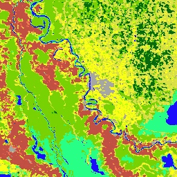
ผลิตภัณฑ์ MCD12Q1 V6 มีประเภทการปกคลุมพื้นดินทั่วโลกเป็นช่วงปี (2001-2016) ซึ่งได้มาจากรูปแบบการจัดประเภทที่แตกต่างกัน 6 รูปแบบ โดยได้มาจาก การแยกประเภทที่มีการกำกับดูแลของข้อมูลการสะท้อนแสงจาก MODIS Terra และ Aqua จากนั้นการแยกประเภทภายใต้การกำกับดูแลจะได้รับการประมวลผลภายหลังเพิ่มเติม ซึ่งจะรวมความรู้ก่อนหน้าและข้อมูลเสริมเพื่อปรับแต่งคลาสที่เฉพาะเจาะจงให้ดียิ่งขึ้น
เอกสารประกอบ:
ย่านความถี่
ย่านความถี่
ขนาดพิกเซล: 500 เมตร (ทุกแถบ)
| ชื่อ | หน่วย | ต่ำสุด | สูงสุด | ขนาดพิกเซล | คำอธิบาย |
|---|---|---|---|---|---|
LC_Type1 |
500 เมตร | ประเภทการปกคลุมพื้นดิน 1: การจัดประเภท International Geosphere-Biosphere Programme (IGBP) ประจำปี |
|||
LC_Type2 |
500 เมตร | ประเภทการปกคลุมพื้นดิน 2: การจัดประเภทประจำปีของมหาวิทยาลัยแมริแลนด์ (UMD) |
|||
LC_Type3 |
500 เมตร | ประเภทการปกคลุมพื้นดิน 3: การแยกประเภทดัชนีพื้นที่ใบ (LAI) ประจำปี |
|||
LC_Type4 |
500 เมตร | ประเภทการปกคลุมพื้นดิน 4: การจัดประเภท BIOME-Biogeochemical Cycles (BGC) ประจำปี |
|||
LC_Type5 |
500 เมตร | ประเภทการปกคลุมของพื้นดิน 5: การจำแนกประเภทประเภทฟังก์ชันพืชประจำปี |
|||
LC_Prop1_Assessment |
% | 0 | 100 | 500 เมตร | ความมั่นใจของเลเยอร์สิ่งปกคลุมดิน LCCS1 |
LC_Prop2_Assessment |
% | 0 | 100 | 500 เมตร | ความน่าเชื่อถือของเลเยอร์การใช้ที่ดิน LCCS2 |
LC_Prop3_Assessment |
% | 0 | 100 | 500 เมตร | ความเชื่อมั่นของเลเยอร์อุทกวิทยาของพื้นผิว LCCS3 |
LC_Prop1 |
500 เมตร | เลเยอร์สิ่งปกคลุมดินของระบบการจัดประเภทสิ่งปกคลุมดิน 1 (LCCS1) ของ FAO |
|||
LC_Prop2 |
500 เมตร | เลเยอร์การใช้ประโยชน์ที่ดิน FAO-LCCS2 |
|||
LC_Prop3 |
500 เมตร | เลเยอร์อุทกวิทยาของพื้นผิว FAO-LCCS3 |
|||
QC |
500 เมตร | มีรายงานปัญหาคุณภาพของผลิตภัณฑ์ |
|||
LW |
500 เมตร | มาสก์แบบไบนารีสำหรับระบุพื้นที่บก (คลาส 2) / น้ำ (คลาส 1) ที่ได้จาก MOD44W |
ตารางคลาส LC_Type1
| ค่า | สี | คำอธิบาย |
|---|---|---|
| 1 | #05450a | ป่าเข็มไม่ผลัดใบ: มีต้นสนไม่ผลัดใบเป็นพืชเด่น (เรือนยอดสูงกว่า 2 เมตร) มีร่มไม้มากกว่า 60% |
| 2 | #086a10 | ป่าไม่ผลัดใบที่มีใบกว้าง: มีต้นไม้ไม่ผลัดใบที่มีใบกว้างและต้นปาล์มเป็นหลัก (เรือนยอด > 2 ม.) มีร่มไม้มากกว่า 60% |
| 3 | #54a708 | ป่าสนผลัดใบ: มีต้นสนผลัดใบ (ต้นสนชนิดหนึ่ง) เป็นพืชเด่น (เรือนยอด > 2 ม.) มีร่มไม้มากกว่า 60% |
| 4 | #78d203 | ป่าผลัดใบที่มีใบกว้าง: มีต้นไม้ผลัดใบที่มีใบกว้างเป็นหลัก (เรือนยอด > 2 ม.) มีร่มไม้มากกว่า 60% |
| 5 | #009900 | ป่าผสม: ไม่มีไม้ใดครอบงำชัดเจนทั้งผลัดใบและไม่ผลัดใบ (40-60% ของแต่ละประเภท) (เรือนยอด >2 ม.) มีร่มไม้มากกว่า 60% |
| 6 | #c6b044 | พุ่มไม้หนาแน่น: มีพืชยืนต้นที่เป็นเนื้อไม้เป็นหลัก (สูง 1-2 ม.) ครอบคลุมมากกว่า 60% |
| 7 | #dcd159 | พุ่มไม้เบาบาง: มีพืชยืนต้นที่เป็นเนื้อไม้เป็นหลัก (สูง 1-2 ม.) ปกคลุม 10-60% |
| 8 | #dade48 | ทุ่งหญ้าสะวันนาที่มีต้นไม้: มีร่มไม้ 30-60% (เรือนยอด >2 ม.) |
| 9 | #fbff13 | ทุ่งหญ้าสะวันนา: มีร่มไม้ 10-30% (เรือนยอด >2 ม.) |
| 10 | #b6ff05 | ทุ่งหญ้า: มีพืชล้มลุกอายุปีเดียวเป็นพืชเด่น (สูงน้อยกว่า 2 ม.) |
| 11 | #27ff87 | พื้นที่ชุ่มน้ำถาวร: พื้นที่ที่ถูกน้ำท่วมถาวรโดยมี น้ำปกคลุม 30-60% และมีพืชปกคลุมมากกว่า 10% |
| 12 | #c24f44 | พื้นที่เพาะปลูก |
| 13 | #a5a5a5 | พื้นที่เมืองและพื้นที่ที่มีสิ่งปลูกสร้าง: พื้นที่ผิวที่ไม่ซึมน้ำอย่างน้อย 30% รวมถึงวัสดุก่อสร้าง แอสฟัลต์ และยานพาหนะ |
| 14 | #ff6d4c | พื้นที่เพาะปลูกผสมพืชพรรณธรรมชาติ: พื้นที่เพาะปลูกขนาดเล็ก 40-60% ผสมผสานต้นไม้ พุ่มไม้ หรือพืชล้มลุก ตามธรรมชาติ |
| 15 | #69fff8 | หิมะและน้ำแข็งถาวร: พื้นที่อย่างน้อย 60% ปกคลุมด้วยหิมะและน้ำแข็งอย่างน้อย 10 เดือนต่อปี |
| 16 | #f9ffa4 | (ทราย หิน ดิน) ที่มีพืชพรรณน้อยกว่า 10% |
| 17 | #1c0dff | แหล่งน้ำ: พื้นที่อย่างน้อย 60% ปกคลุมด้วย แหล่งน้ำถาวร |
ตารางคลาส LC_Type2
| ค่า | สี | คำอธิบาย |
|---|---|---|
| 0 | #1c0dff | แหล่งน้ำ: พื้นที่อย่างน้อย 60% ปกคลุมด้วย แหล่งน้ำถาวร |
| 1 | #05450a | ป่าเข็มไม่ผลัดใบ: มีต้นสนไม่ผลัดใบเป็นพืชเด่น (เรือนยอดสูงกว่า 2 เมตร) มีร่มไม้มากกว่า 60% |
| 2 | #086a10 | ป่าไม่ผลัดใบที่มีใบกว้าง: มีต้นไม้ไม่ผลัดใบที่มีใบกว้างและต้นปาล์มเป็นหลัก (เรือนยอด > 2 ม.) มีร่มไม้มากกว่า 60% |
| 3 | #54a708 | ป่าสนผลัดใบ: มีต้นสนผลัดใบ (ต้นสนชนิดหนึ่ง) เป็นพืชเด่น (เรือนยอด > 2 ม.) มีร่มไม้มากกว่า 60% |
| 4 | #78d203 | ป่าผลัดใบที่มีใบกว้าง: มีต้นไม้ผลัดใบที่มีใบกว้างเป็นหลัก (เรือนยอด > 2 ม.) มีร่มไม้มากกว่า 60% |
| 5 | #009900 | ป่าผสม: ไม่มีไม้ใดครอบงำชัดเจนทั้งผลัดใบและไม่ผลัดใบ (40-60% ของแต่ละประเภท) (เรือนยอด >2 ม.) มีร่มไม้มากกว่า 60% |
| 6 | #c6b044 | พุ่มไม้หนาแน่น: มีพืชยืนต้นที่เป็นเนื้อไม้เป็นหลัก (สูง 1-2 ม.) ครอบคลุมมากกว่า 60% |
| 7 | #dcd159 | พุ่มไม้เบาบาง: มีพืชยืนต้นที่เป็นเนื้อไม้เป็นหลัก (สูง 1-2 ม.) ปกคลุม 10-60% |
| 8 | #dade48 | ทุ่งหญ้าสะวันนาที่มีต้นไม้: มีร่มไม้ 30-60% (เรือนยอด >2 ม.) |
| 9 | #fbff13 | ทุ่งหญ้าสะวันนา: มีร่มไม้ 10-30% (เรือนยอด >2 ม.) |
| 10 | #b6ff05 | ทุ่งหญ้า: มีพืชล้มลุกอายุปีเดียวเป็นพืชเด่น (สูงน้อยกว่า 2 ม.) |
| 11 | #27ff87 | พื้นที่ชุ่มน้ำถาวร: พื้นที่ที่ถูกน้ำท่วมถาวรโดยมี น้ำปกคลุม 30-60% และมีพืชปกคลุมมากกว่า 10% |
| 12 | #c24f44 | พื้นที่เพาะปลูก |
| 13 | #a5a5a5 | พื้นที่เมืองและพื้นที่ที่มีสิ่งปลูกสร้าง: พื้นที่ผิวที่ไม่ซึมน้ำอย่างน้อย 30% รวมถึงวัสดุก่อสร้าง แอสฟัลต์ และยานพาหนะ |
| 14 | #ff6d4c | พื้นที่เพาะปลูกผสมพืชพรรณธรรมชาติ: พื้นที่เพาะปลูกขนาดเล็ก 40-60% ผสมผสานต้นไม้ พุ่มไม้ หรือพืชล้มลุก ตามธรรมชาติ |
| 15 | #f9ffa4 | พื้นที่ที่ไม่มีพืชปกคลุม: พื้นที่อย่างน้อย 60% เป็นพื้นที่แห้งแล้งที่ไม่มีพืชปกคลุม (ทราย หิน ดิน) หรือหิมะและน้ำแข็งถาวรที่มีพืชปกคลุมน้อยกว่า 10% |
ตารางคลาส LC_Type3
| ค่า | สี | คำอธิบาย |
|---|---|---|
| 0 | #1c0dff | แหล่งน้ำ: พื้นที่อย่างน้อย 60% ปกคลุมด้วยแหล่งน้ำถาวร |
| 1 | #b6ff05 | ทุ่งหญ้า: มีพืชล้มลุกอายุปีเดียวเป็นพืชเด่น (<2 ม.) รวมถึงพื้นที่เพาะปลูกธัญพืช |
| 2 | #dcd159 | พุ่มไม้: พุ่มไม้ (1-2 ม.) ครอบคลุมมากกว่า 10% |
| 3 | #c24f44 | พื้นที่เพาะปลูกที่มีใบกว้าง: มีพืชล้มลุกอายุปีเดียวเป็นหลัก (<2 ม.) ซึ่งปลูกร่วมกับพืชใบกว้าง |
| 4 | #fbff13 | ทุ่งหญ้าสะวันนา: ร่มไม้ 10-60% (>2 ม.) |
| 5 | #086a10 | ป่าไม่ผลัดใบที่มีใบกว้าง: มีต้นไม้ไม่ผลัดใบที่มีใบกว้างและต้นปาล์มเป็นหลัก (เรือนยอด > 2 ม.) มีร่มไม้มากกว่า 60% |
| 6 | #78d203 | ป่าผลัดใบที่มีใบกว้าง: มีต้นไม้ผลัดใบที่มีใบกว้างเป็นหลัก (เรือนยอด > 2 ม.) มีร่มไม้มากกว่า 60% |
| 7 | #05450a | ป่าเข็มไม่ผลัดใบ: มีต้นสนไม่ผลัดใบเป็นพืชเด่น (เรือนยอดสูงกว่า 2 เมตร) มีร่มไม้มากกว่า 60% |
| 8 | #54a708 | ป่าสนผลัดใบ: มีต้นสนผลัดใบ (ต้นสนชนิดหนึ่ง) เป็นพืชเด่น (เรือนยอด > 2 ม.) มีร่มไม้มากกว่า 60% |
| 9 | #f9ffa4 | พื้นที่ที่ไม่มีพืชปกคลุม: พื้นที่อย่างน้อย 60% เป็นพื้นที่แห้งแล้งที่ไม่มีพืชปกคลุม (ทราย หิน ดิน) หรือหิมะและน้ำแข็งถาวรที่มีพืชปกคลุมน้อยกว่า 10% |
| 10 | #a5a5a5 | พื้นที่เมืองและพื้นที่ที่มีสิ่งปลูกสร้าง: พื้นที่ผิวที่ไม่ซึมน้ำอย่างน้อย 30% รวมถึงวัสดุก่อสร้าง แอสฟัลต์ และยานพาหนะ |
ตารางคลาส LC_Type4
| ค่า | สี | คำอธิบาย |
|---|---|---|
| 0 | #1c0dff | แหล่งน้ำ: พื้นที่อย่างน้อย 60% ปกคลุมด้วย แหล่งน้ำถาวร |
| 1 | #05450a | พืชพรรณเข็มไม่ผลัดใบ: มีต้นสนไม่ผลัดใบและพุ่มไม้เป็นพืชเด่น (>1 ม.) มีพืชที่เป็นเนื้อไม้มากกว่า 10% |
| 2 | #086a10 | พืชพรรณไม่ผลัดใบที่มีใบกว้าง: มีต้นไม้และพุ่มไม้ไม่ผลัดใบที่มีใบกว้างและต้นปาล์มเป็นหลัก (>1 ม.) พื้นที่พืชพรรณที่เป็นไม้
|
| 3 | #54a708 | พืชสนผลัดใบ: มีต้นไม้และพุ่มไม้สนผลัดใบ (ต้นสนชนิดหนึ่ง) เป็นพืชเด่น (>1 ม.) พื้นที่พืชพรรณที่เป็นไม้
|
| 4 | #78d203 | พืชพรรณผลัดใบที่มีใบกว้าง: มีต้นไม้และพุ่มไม้ผลัดใบที่มีใบกว้างเป็นหลัก (>1 ม.) มีพืชที่เป็นเนื้อไม้มากกว่า 10% |
| 5 | #009900 | พืชใบกว้างประจำปี: มีพืชล้มลุกประจำปีเป็นหลัก (<2 ม.) มีพืชใบกว้างที่เพาะปลูกอย่างน้อย 60% |
| 6 | #b6ff05 | พืชพรรณที่เป็นหญ้าประจำปี: มีพืชล้มลุกที่เป็นพืชประจำปีเป็นหลัก (<2 ม.) รวมถึงพื้นที่เพาะปลูกธัญพืช |
| 7 | #f9ffa4 | พื้นที่ที่ไม่มีพืชปกคลุม: พื้นที่อย่างน้อย 60% เป็นพื้นที่แห้งแล้งที่ไม่มีพืชปกคลุม (ทราย หิน ดิน) หรือหิมะ/น้ำแข็งถาวรที่มีพืชปกคลุมน้อยกว่า 10% |
| 8 | #a5a5a5 | พื้นที่เมืองและพื้นที่ที่มีสิ่งปลูกสร้าง: พื้นที่ผิวที่ไม่ซึมน้ำอย่างน้อย 30% รวมถึงวัสดุก่อสร้าง แอสฟัลต์ และยานพาหนะ |
ตารางคลาส LC_Type5
| ค่า | สี | คำอธิบาย |
|---|---|---|
| 0 | #1c0dff | แหล่งน้ำ: พื้นที่อย่างน้อย 60% ปกคลุมด้วยแหล่งน้ำถาวร |
| 1 | #05450a | ต้นไม้เข็มไม่ผลัดใบ: มีต้นสนไม่ผลัดใบเป็นพืชเด่น (สูงกว่า 2 เมตร) มีร่มไม้มากกว่า 10% |
| 2 | #086a10 | ต้นไม้ไม่ผลัดใบที่มีใบกว้าง: มีต้นไม้ไม่ผลัดใบที่มีใบกว้างและต้นปาล์มเป็นหลัก (>2 ม.) มีร่มไม้มากกว่า 10% |
| 3 | #54a708 | ต้นสนผลัดใบ: มีต้นสนผลัดใบ (ต้นสนชนิดหนึ่ง) เป็นพืชเด่น (>2 ม.) มีร่มไม้มากกว่า 10% |
| 4 | #78d203 | ต้นไม้ผลัดใบที่มีใบกว้าง: มีต้นไม้ผลัดใบที่มีใบกว้างเป็นหลัก (>2 ม.) มีร่มไม้มากกว่า 10% |
| 5 | #dcd159 | พุ่มไม้: พุ่มไม้ (1-2 ม.) ปกคลุมมากกว่า 10% |
| 6 | #b6ff05 | ไม่ได้เพาะปลูก |
| 7 | #dade48 | พื้นที่เพาะปลูกธัญพืช: มีพืชล้มลุกอายุปีเดียวเป็นหลัก (<2 ม.) พืชธัญพืชที่เพาะปลูกอย่างน้อย 60% |
| 8 | #c24f44 | พื้นที่เพาะปลูกที่มีใบกว้าง: มีพืชล้มลุกอายุ 1 ปีเป็นหลัก (<2 ม.) มีพืชใบกว้างที่เพาะปลูกอย่างน้อย 60% |
| 9 | #a5a5a5 | พื้นที่เมืองและพื้นที่ที่มีสิ่งปลูกสร้าง: พื้นที่ผิวที่ไม่ซึมน้ำอย่างน้อย 30% รวมถึงวัสดุก่อสร้าง แอสฟัลต์ และยานพาหนะ |
| 10 | #69fff8 | หิมะและน้ำแข็งถาวร: พื้นที่อย่างน้อย 60% ปกคลุมด้วยหิมะและน้ำแข็งเป็นเวลาอย่างน้อย 10 เดือนต่อปี |
| 11 | #f9ffa4 | พื้นที่ที่ไม่มีพืชปกคลุม: พื้นที่อย่างน้อย 60% เป็นพื้นที่แห้งแล้งที่ไม่มีพืชปกคลุม (ทราย หิน ดิน) โดยมีพืชปกคลุมน้อยกว่า 10% |
ตารางคลาส LC_Prop1
| ค่า | สี | คำอธิบาย |
|---|---|---|
| 1 | #f9ffa4 | (ทราย หิน ดิน) หรือหิมะ/น้ำแข็งถาวรที่มีพืชพรรณน้อยกว่า 10% |
| 2 | #69fff8 | หิมะและน้ำแข็งถาวร: พื้นที่อย่างน้อย 60% ปกคลุมด้วยหิมะและน้ำแข็งเป็นเวลาอย่างน้อย 10 เดือนต่อปี |
| 3 | #1c0dff | แหล่งน้ำ: พื้นที่อย่างน้อย 60% ปกคลุมด้วย แหล่งน้ำถาวร |
| 11 | #05450a | ป่าเข็มไม่ผลัดใบ: มีต้นสนไม่ผลัดใบเป็นพืชเด่น (สูงกว่า 2 เมตร) มีร่มไม้มากกว่า 60% |
| 12 | #086a10 | ป่าไม่ผลัดใบที่มีใบกว้าง: มีต้นไม้ไม่ผลัดใบที่มีใบกว้างและต้นปาล์มเป็นหลัก (>2 ม.) มีร่มไม้มากกว่า 60% |
| 13 | #54a708 | ป่าสนผลัดใบ: มีต้นสนผลัดใบ (ต้นสนชนิดหนึ่ง) เป็นพืชเด่น (>2 ม.) มีร่มไม้มากกว่า 60% |
| 14 | #78d203 | ป่าผลัดใบที่มีใบกว้าง: มีต้นไม้ผลัดใบที่มีใบกว้างเป็นหลัก (>2 ม.) มีร่มไม้มากกว่า 60% |
| 15 | #005a00 | ป่าผสมที่มีใบกว้าง/ใบเข็ม: มีต้นไม้ผลัดใบที่มีใบกว้างและต้นไม้ไม่ผลัดใบที่มีใบเข็มเป็นพืชเด่นร่วมกัน (40-60%) (>2 ม.) มีร่มไม้มากกว่า 60% |
| 16 | #009900 | ป่าผสมไม่ผลัดใบ/ผลัดใบที่มีใบกว้าง: มีต้นไม้ไม่ผลัดใบและผลัดใบที่มีใบกว้างเป็นพืชเด่นร่วมกัน (40-60%) (>2 ม.) มีร่มไม้มากกว่า 60% |
| 21 | #006c00 | ป่าโปร่ง: มีร่มไม้ 30-60% (เรือนยอด >2 ม.) |
| 22 | #00d000 | ป่าโปร่ง: มีร่มไม้ 10-30% (เรือนยอด >2 ม.) |
| 31 | #b6ff05 | พืชล้มลุกหนาแน่น: มีพืชล้มลุกอายุปีเดียวเป็นหลัก (<2 ม.) ปกคลุมอย่างน้อย 60% |
| 32 | #98d604 | พืชล้มลุกเบาบาง: มีพืชล้มลุกอายุ 1 ปีเป็นหลัก (<2 ม.) ปกคลุม 10-60% |
| 41 | #dcd159 | พุ่มไม้หนาแน่น: มีพืชยืนต้นที่เป็นเนื้อไม้เป็นหลัก (1-2 ม.)
|
| 42 | #f1fb58 | พุ่มไม้ผสมทุ่งหญ้า: มีพืชยืนต้นที่เป็นเนื้อไม้เป็นหลัก (สูง 1-2 ม.) ปกคลุม 10-60% โดยมีพืชล้มลุกหนาแน่นเป็นพืชชั้นล่าง |
| 43 | #fbee65 | พุ่มไม้เบาบาง: มีพืชยืนต้นที่เป็นเนื้อไม้เป็นหลัก (1-2 ม.) ปกคลุม 10-60% โดยมีพืชคลุมดินที่เป็นพืชล้มลุกน้อยที่สุด |
ตารางคลาส LC_Prop2
| ค่า | สี | คำอธิบาย |
|---|---|---|
| 1 | #f9ffa4 | (ทราย หิน ดิน) หรือหิมะ/น้ำแข็งถาวรที่มีพืชพรรณน้อยกว่า 10% |
| 2 | #69fff8 | หิมะและน้ำแข็งถาวร: พื้นที่อย่างน้อย 60% ปกคลุมด้วยหิมะและน้ำแข็งเป็นเวลาอย่างน้อย 10 เดือนต่อปี |
| 3 | #1c0dff | แหล่งน้ำ: พื้นที่อย่างน้อย 60% ปกคลุมด้วย แหล่งน้ำถาวร |
| 9 | #a5a5a5 | พื้นที่เมืองและพื้นที่ที่มีสิ่งปลูกสร้าง: พื้นที่อย่างน้อย 30% ประกอบด้วยพื้นผิวที่ไม่ซึมน้ำ รวมถึงวัสดุก่อสร้าง แอสฟัลต์ และยานพาหนะ |
| 10 | #003f00 | ป่าทึบ: มีร่มไม้มากกว่า 60% (เรือนยอด >2 ม.) |
| 20 | #006c00 | ป่าโปร่ง: มีร่มไม้ 10-60% (เรือนยอด >2 ม.) |
| 25 | #e3ff77 | พื้นที่ป่าผสมพื้นที่เพาะปลูก: พื้นที่เพาะปลูกขนาดเล็ก 40-60% ผสมผสาน มีร่มไม้ตามธรรมชาติมากกว่า 10% |
| 30 | #b6ff05 | พืชสมุนไพรธรรมชาติ: มีพืชสมุนไพรล้มลุกเป็นพืชเด่น (<2 ม.) มีส่วนปกคลุมอย่างน้อย 10% |
| 35 | #93ce04 | พื้นที่เพาะปลูกผสมพืชล้มลุกตามธรรมชาติ: พื้นที่เพาะปลูกขนาดเล็ก 40-60% ผสมผสานพุ่มไม้หรือพืชล้มลุก ตามธรรมชาติ |
| 36 | #77a703 | พื้นที่เพาะปลูกที่เป็นพืชล้มลุก: มีพืชล้มลุกอายุปีเดียวเป็นพืชเด่น (<2 ม.) ครอบคลุมอย่างน้อย 60% พื้นที่เพาะปลูกมากกว่า 60% |
| 40 | #dcd159 | พุ่มไม้: มีพุ่มไม้ปกคลุมมากกว่า 60% (1-2 ม.) |
ตารางคลาส LC_Prop3
| ค่า | สี | คำอธิบาย |
|---|---|---|
| 1 | #f9ffa4 | (ทราย หิน ดิน) หรือหิมะ/น้ำแข็งถาวรที่มีพืชพรรณน้อยกว่า 10% |
| 2 | #69fff8 | หิมะและน้ำแข็งถาวร: พื้นที่อย่างน้อย 60% ปกคลุมด้วยหิมะและน้ำแข็งเป็นเวลาอย่างน้อย 10 เดือนต่อปี |
| 3 | #1c0dff | แหล่งน้ำ: พื้นที่อย่างน้อย 60% ปกคลุมด้วย แหล่งน้ำถาวร |
| 10 | #003f00 | ป่าทึบ: มีร่มไม้มากกว่า 60% (เรือนยอด >2 ม.) |
| 20 | #006c00 | ป่าโปร่ง: มีร่มไม้ 10-60% (เรือนยอด >2 ม.) |
| 27 | #72834a | พื้นที่ชุ่มน้ำที่เป็นไม้: มีพุ่มไม้และร่มไม้มากกว่า 10% (>1 ม.) น้ำท่วมถาวรหรือตามฤดูกาล |
| 30 | #b6ff05 | ทุ่งหญ้า: มีพืชล้มลุกอายุ 1 ปีเป็นหลัก (<2 ม.) ปกคลุมมากกว่า 10% |
| 40 | #c6b044 | พุ่มไม้: มีพุ่มไม้ปกคลุมมากกว่า 60% (1-2 ม.) |
| 50 | #3aba73 | พื้นที่ชุ่มน้ำที่เป็นพืชล้มลุก: มีพืชล้มลุกประจำปีเป็นหลัก (<2 ม.) ปกคลุมมากกว่า 10% น้ำท่วมถาวรหรือตามฤดูกาล |
| 51 | #1e9db3 | เดือนของปี |
ตารางคลาส QC
| ค่า | สี | คำอธิบาย |
|---|---|---|
| 0 | ไม่มี | ที่ดินที่แยกประเภท: มีป้ายกำกับการแยกประเภทและเป็นที่ดิน ตามมาสก์น้ำ |
| 1 | ไม่มี | ที่ดินที่ไม่ได้จัดประเภท: ไม่ได้จัดประเภทเนื่องจากไม่มีข้อมูล แต่เป็นที่ดินตามมาสก์น้ำ โดยติดป้ายกำกับว่าแห้งแล้ง |
| 2 | ไม่มี | น้ำที่แยกประเภท: มีป้ายกำกับการแยกประเภทและเป็น น้ำตามมาสก์น้ำ |
| 3 | ไม่มี | น้ำที่ไม่ได้จัดประเภท: ไม่ได้จัดประเภทเนื่องจากไม่มีข้อมูล แต่เป็นน้ำตามมาสก์น้ำ |
| 4 | ไม่มี | น้ำแข็งในทะเลที่จัดประเภท: จัดประเภทเป็นหิมะ/น้ำแข็ง แต่มาสก์ระบุว่าเป็นน้ำและมีความสูงน้อยกว่า 100 เมตร จึงเปลี่ยนเป็นน้ำ |
| 5 | ไม่มี | น้ำที่แยกประเภทผิด: แยกประเภทเป็นน้ำ แต่มาสก์น้ำ ระบุว่าเป็นพื้นดิน จึงเปลี่ยนไปใช้ป้ายกำกับรอง |
| 6 | ไม่มี | หิมะ/น้ำแข็งที่ละเว้น: พื้นที่ตามมาสก์น้ำที่ จัดประเภทเป็นอย่างอื่นที่ไม่ใช่หิมะ แต่มีอุณหภูมิสูงสุดต่อปี ต่ำกว่า 1°C จะได้รับการติดป้ายกำกับใหม่เป็นหิมะ/น้ำแข็ง |
| 7 | ไม่มี | หิมะ/น้ำแข็งที่จัดประเภทผิด: พื้นที่ตามมาสก์น้ำ ที่จัดประเภทเป็นหิมะแต่มีอุณหภูมิต่ำสุดรายปี มากกว่า 1°C จะได้รับการติดป้ายกำกับใหม่เป็นพื้นที่แห้งแล้ง |
| 8 | ไม่มี | ป้ายกำกับที่เติมข้อมูลย้อนหลัง: ป้ายกำกับที่ขาดหายไปจากระบบกันภาพสั่น เติมด้วยผลลัพธ์ที่ผ่านการกันภาพสั่นล่วงหน้า |
| 9 | ไม่มี | เปลี่ยนประเภทป่าไม้: เปลี่ยนตามสภาพภูมิอากาศเป็นชั้นป่าไม้ |
ตารางคลาส LW
| ค่า | สี | คำอธิบาย |
|---|---|---|
| 1 | #1c0dff | น้ำ |
| 2 | #f9ffa4 | ที่ดิน |
ข้อกำหนดในการใช้งาน
ข้อกำหนดในการใช้งาน
ข้อมูลและผลิตภัณฑ์ MODIS ที่ได้จาก LP DAAC ไม่มีข้อจำกัดในการนำไปใช้ ขาย หรือแจกจ่ายต่อ
การอ้างอิง
โปรดไปที่หน้า "การอ้างอิงข้อมูลของเรา" ของ LP DAAC เพื่อดูข้อมูลเกี่ยวกับการอ้างอิงชุดข้อมูล LP DAAC
DOI
สำรวจด้วย Earth Engine
ตัวแก้ไขโค้ด (JavaScript)
var dataset = ee.ImageCollection('MODIS/006/MCD12Q1');
var igbpLandCover = dataset.select('LC_Type1');
var igbpLandCoverVis = {
  min: 1.0,
  max: 17.0,
  palette: [
    '05450a', '086a10', '54a708', '78d203', '009900', 'c6b044', 'dcd159',
    'dade48', 'fbff13', 'b6ff05', '27ff87', 'c24f44', 'a5a5a5', 'ff6d4c',
    '69fff8', 'f9ffa4', '1c0dff'
  ],
};
Map.setCenter(6.746, 46.529, 6);
Map.addLayer(igbpLandCover, igbpLandCoverVis, 'IGBP Land Cover');
import ee
import geemap.core as geemap
Colab (Python)
dataset = ee.ImageCollection('MODIS/006/MCD12Q1')

igbp_land_cover = dataset.select('LC_Type1')

igbp_land_cover_vis = {
    'min': 1.0,
    'max': 17.0,
    'palette': [
        '05450a', '086a10', '54a708', '78d203', '009900', 'c6b044', 'dcd159',
        'dade48', 'fbff13', 'b6ff05', '27ff87', 'c24f44', 'a5a5a5', 'ff6d4c',
        '69fff8', 'f9ffa4', '1c0dff'
    ],
}

m = geemap.Map()
m.set_center(6.746, 46.529, 6)
m.add_layer(igbp_land_cover, igbp_land_cover_vis, 'IGBP Land Cover')
m