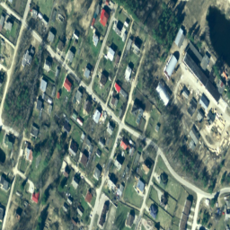
라트비아에서는 TKS-93 지도 시트 구분 (1:10000 지도 시트는 실제 5x5km에 해당)에 따라 라트비아 좌표계 LKS-92 TM으로 정사영 지도 시트를 준비합니다. 직교사진 지도는 라트비아 전체 지역에 대해 1:10000의 축척으로 준비되지만, 별도의 지역(도시 및 인구 밀도가 높은 지역)의 경우 1:2000 또는 1:1000의 축척으로 준비됩니다.
[[["이해하기 쉬움","easyToUnderstand","thumb-up"],["문제가 해결됨","solvedMyProblem","thumb-up"],["기타","otherUp","thumb-up"]],[["필요한 정보가 없음","missingTheInformationINeed","thumb-down"],["너무 복잡함/단계 수가 너무 많음","tooComplicatedTooManySteps","thumb-down"],["오래됨","outOfDate","thumb-down"],["번역 문제","translationIssue","thumb-down"],["샘플/코드 문제","samplesCodeIssue","thumb-down"],["기타","otherDown","thumb-down"]],[],[],["The dataset provides Latvia's orthophoto maps from 2007 to 2018, available via Google Earth Engine. These RGB images, sourced from the Latvian Geospatial Information Agency, cover all of Latvia at a 1:10000 scale, with higher resolutions for urban areas. The dataset, in LKS-92 TM coordinates, has 0.2-meter pixel size and offers red, green, and blue bands (0-255 range). Access the dataset using the `ee.ImageCollection(\"Latvia/Maamet/orthos/rgb\")` code snippet.\n"]]