- Disponibilidade do conjunto de dados
- 2014-09-01T00:00:00Z–2014-09-01T00:00:00Z
- Produtor de conjunto de dados
- Departamento de Agricultura dos EUA (USDA), Serviço Florestal dos EUA (USFS), Pesquisa Geológica do Departamento do Interior dos EUA (USGS) e The Nature Conservancy.
- Tags
Descrição
O LANDFIRE (LF), Landscape Fire and Resource Management Planning Tools, é um programa compartilhado entre os programas de gerenciamento de incêndios florestais do Serviço Florestal do Departamento de Agricultura dos EUA, do Serviço Geológico do Departamento do Interior dos EUA e da The Nature Conservancy.
Os regimes de incêndio históricos, os intervalos e as condições de vegetação do Landfire (LF) são mapeados usando a ferramenta de desenvolvimento de dinâmica da vegetação (VDDT, na sigla em inglês). Esses dados apoiam as metas de planejamento de gerenciamento de incêndios e paisagens na Estratégia Nacional Coesa de Gerenciamento de Incêndios Florestais, na Política Federal de Gerenciamento de Incêndios Florestais e na Lei de Restauração de Florestas Saudáveis.
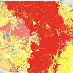
A classe de condição da vegetação (VCC, na sigla em inglês) representa uma categorização simples da camada associada de variação da vegetação (VDEP, na sigla em inglês) e indica o nível geral em que a vegetação atual é diferente das condições de referência históricas simuladas. O VDEP e o VCC se baseiam em métodos originalmente descritos no Interagency Fire Regime Condition Class Guidebook, mas não são idênticos a eles. As descrições completas dos métodos usados podem ser encontradas na descrição do produto VDEP. Os usuários precisam revisar esses métodos antes de comparar valores de VDEP ou VCC em versões do LANDFIRE (LF). O VCC é um derivado da camada VDEP. É importante ler e entender as características do produto espacial VDEP, principalmente se os valores de VCC forem comparados entre versões, já que os métodos de VDEP variam, o que afeta diretamente a comparabilidade entre versões de VDEP e VCC. Em LF 2012, as três classes originais de VCC foram divididas pela metade para criar seis classes e oferecer mais precisão.
Os conjuntos de dados de incêndio do LANDIFRE incluem:
- Os grupos de regime de incêndio (FRG, na sigla em inglês) têm como objetivo caracterizar regimes de incêndio históricos presumidos em paisagens com base nas interações entre a dinâmica da vegetação, a propagação e os efeitos do fogo e o contexto espacial.
- O intervalo médio entre incêndios (MFRI, na sigla em inglês) quantifica o período médio entre incêndios no regime histórico presumido.
- A porcentagem de incêndios de baixa gravidade (PLS, na sigla em inglês) quantifica a quantidade de incêndios de baixa gravidade em relação aos incêndios de gravidade mista e de substituição no regime histórico presumido de incêndios. Ela é definida como menos de 25% de morte da parte superior média dentro de um perímetro típico de incêndio para um determinado tipo de vegetação.
- A porcentagem da camada de incêndio de gravidade mista (PMS, na sigla em inglês) quantifica a quantidade de incêndios de gravidade mista em relação aos de gravidade baixa e de substituição no regime histórico presumido de incêndios. Ela é definida como entre 25% e 75% de média de morte da parte superior da vegetação em um perímetro típico de incêndio para um determinado tipo de vegetação.
- A porcentagem da camada de incêndios de gravidade de substituição (PRS, na sigla em inglês) quantifica a quantidade de incêndios de gravidade de substituição em relação aos incêndios de gravidade baixa e mista no regime histórico presumido de incêndios. Ela é definida como mais de 75% de mortalidade média de copa em um perímetro típico de incêndio para um determinado tipo de vegetação.
- A camada de classes de sucessão (SClass, na sigla em inglês) caracteriza as condições atuais da vegetação em relação à composição de espécies, cobertura e intervalos de altura dos estados de sucessão que ocorrem em cada ambiente biofísico.
- A classe de condição da vegetação (VCC, na sigla em inglês) representa uma categorização simples da camada associada de afastamento da vegetação (VDEP, na sigla em inglês) e indica o nível geral em que a vegetação atual é diferente das condições de referência históricas simuladas da vegetação.
- A variação da vegetação (VDep, na sigla em inglês) indica a diferença entre a vegetação atual em uma paisagem e as condições históricas estimadas. O VDep se baseia em mudanças na composição de espécies, no estágio estrutural e no fechamento da copa.
Bandas
Bandas
Tamanho do pixel: 30 metros (todas as bandas)
| Nome | Tamanho do pixel | Descrição |
|---|---|---|
VCC |
30 metros | Classe de condição da vegetação |
Tabela de classes de VCC
| Valor | Cor | Descrição |
|---|---|---|
| 1 | #38a800 | Muito baixo, variação da vegetação de 0 a 16% |
| 2 | #4ce600 | Baixo a moderado, variação de vegetação de 17% a 33% |
| 3 | #ffff00 | Moderado a baixo, redução de vegetação de 34 a 50% |
| 4 | #ffaa00 | Moderado a alto, variação de vegetação de 51 a 66% |
| 5 | #ff0000 | Alto, redução da vegetação de 67 a 83% |
| 6 | #a80000 | Muito alta, variação da vegetação de 84 a 100% |
| 111 | #0000ff | Água |
| 112 | #c8ffff | Neve / gelo |
| 120 | #8400a8 | Non burnable Urban |
| 121 | #f516b6 | Burnable Urban |
| 131 | #4e4e4e | Barren |
| 132 | #b2b2b2 | Vegetação esparsa |
| 180 | #df73ff | Agricultura sem queimadas |
| 181 | #e8beff | Agricultura de queimadas |
Propriedades de imagens
Propriedades da imagem
| Nome | Tipo | Descrição |
|---|---|---|
| VCC_classes | DOUBLE | Valores de classe da classe de condição da vegetação. |
| VCC_names | STRING | Nomes descritivos da classe de condição da vegetação. |
Termos de Uso
Termos de Uso
Os dados do LANDFIRE são de domínio público e não têm restrições de uso. No entanto, se forem criadas modificações ou derivados dos produtos, adicione um modificador descritivo ao conjunto de dados para evitar confusão.
Citações
A maneira sugerida de citar produtos do LANDFIRE é específica para cada um deles. Por isso, fornecemos o modelo de citação com um exemplo de um produto específico. Produtor. Ano de lançamento. Produto xxxxx:
- Nome do modelo individual.
- BpS Models and Descriptions, Online. LANDFIRE. Washington, D.C. Departamento de Agricultura dos EUA, Serviço Florestal
- Departamento do Interior dos EUA; Serviço Geológico dos EUA; Arlington, VA
- The Nature Conservancy (produtores). Disponível: URL. Data de acesso.
Exemplo de citação: LANDFIRE Biophysical Settings. 2018. Ambiente biofísico 14420: pradaria de areia do sul do Texas. In: LANDFIRE Biophysical Setting Model: Map zone 36, [Online]. Em: BpS Models and Descriptions. Em: LANDFIRE. Washington, DC: U.S. Department of Agriculture, Forest Service; U.S. Department of the Interior; U.S. Geological Survey; Arlington, VA: The Nature Conservancy (Produtores). Disponível em: https://www.landfire.gov/bps-models.php [2018, 27 de junho]. Confira mais orientações sobre como citar produtos do LANDFIRE neste link
Explore com o Earth Engine
Editor de código (JavaScript)
var dataset = ee.ImageCollection('LANDFIRE/Fire/VCC/v1_4_0');

var visualization = {
  bands: ['VCC'],
};

Map.setCenter(-121.671, 40.699, 5);

Map.addLayer(dataset, visualization, 'VCC');