- ความพร้อมใช้งานของชุดข้อมูล
- 2014-09-01T00:00:00Z–2014-09-01T00:00:00Z
- ผู้ผลิตชุดข้อมูล
- กระทรวงเกษตรของสหรัฐอเมริกา (USDA), กรมป่าไม้ของสหรัฐอเมริกา (USFS), กรมสำรวจทางธรณีวิทยาของกระทรวงมหาดไทยของสหรัฐอเมริกา (USGS) และ The Nature Conservancy
- แท็ก
คำอธิบาย
LANDFIRE (LF) หรือเครื่องมือวางแผนการจัดการไฟป่าและทรัพยากรในภูมิทัศน์เป็นโปรแกรมที่ใช้ร่วมกันระหว่างโปรแกรมการจัดการไฟป่าของกรมป่าไม้ กระทรวงเกษตรของสหรัฐอเมริกา, กรมสำรวจทางธรณีวิทยา กระทรวงมหาดไทยของสหรัฐอเมริกา และ The Nature Conservancy
ระบบจะแมปรูปแบบไฟ ช่วงเวลา และสภาพพืชพรรณในอดีตของ Landfire (LF) โดยใช้เครื่องมือพัฒนาพลวัตของพืชพรรณ (VDDT) ข้อมูลเหล่านี้สนับสนุนเป้าหมายการวางแผนการจัดการไฟและภูมิทัศน์ใน ยุทธศาสตร์การจัดการไฟป่าที่สอดคล้องกันระดับประเทศ นโยบายการจัดการไฟป่าของรัฐบาลกลาง และกฎหมายว่าด้วยการฟื้นฟูป่าที่สมบูรณ์
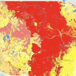
เลเยอร์ Succession Classes (SClass) จะอธิบายลักษณะสภาพพืชพรรณในปัจจุบันโดยอิงตามองค์ประกอบของชนิดพืชพรรณ ความครอบคลุม และช่วงความสูงของสถานะการเปลี่ยนแปลงที่เกิดขึ้นภายในแต่ละการตั้งค่าทางชีวฟิสิกส์ นอกจากนี้ SClass ยังแสดงถึงองค์ประกอบของพืชที่ไม่เป็นลักษณะเฉพาะ เช่น พืชต่างถิ่น ซึ่งไม่พบในความแปรปรวนขององค์ประกอบหรือโครงสร้างของสถานะการเปลี่ยนแปลงที่กำหนดไว้สำหรับการตั้งค่าทางชีวฟิสิกส์ คลาสการสืบทอดไม่ได้ระบุลักษณะเชื้อเพลิงของพืชพรรณปัจจุบันโดยตรง แต่แสดงถึงสถานะของพืชที่มีการสืบทอดหรือการรบกวนที่เกี่ยวข้องกับไดนามิกที่ไม่เหมือนใคร เช่น การพัฒนาโครงสร้างหรือความถี่ของไฟ ในการสร้าง SClass เราได้นำสภาวะอ้างอิงในอดีตของสถานะการเปลี่ยนแปลงเหล่านี้มาจากโมเดล VDDT (เครื่องมือพัฒนาพลวัตของพืช) (LF_1.0.0 CONUS ใช้เฉพาะโมเดลพลวัตของพืชและการรบกวน LANDSUM) พื้นที่ที่อยู่ในชั้นเรียนการสืบทอดจะได้รับการเปรียบเทียบกับสภาพอ้างอิงทางประวัติศาสตร์ที่จำลองขึ้นเพื่อคำนวณการวัดการเปลี่ยนแปลงของพืช เช่น ชั้นเรียนสภาพของรูปแบบไฟ SClass ใช้ในการประเมินแนวนอน
ชุดข้อมูลไฟป่า LANDIFRE ประกอบด้วยข้อมูลต่อไปนี้
- กลุ่มรูปแบบไฟ (FRG) มีจุดประสงค์เพื่ออธิบายลักษณะของรูปแบบไฟในอดีตที่คาดการณ์ไว้ภายในภูมิทัศน์ตามปฏิสัมพันธ์ระหว่างพลวัตของพืช การลุกลามของไฟ ผลกระทบจากไฟ และบริบทเชิงพื้นที่
- ช่วงเวลาเฉลี่ยระหว่างไฟ (MFRI) จะวัดปริมาณระยะเวลาเฉลี่ยระหว่างไฟภายใต้ระบอบไฟในอดีตที่สันนิษฐาน
- รูปภาพเปอร์เซ็นต์ไฟที่มีความรุนแรงต่ำ (PLS) จะวัดปริมาณไฟที่มีความรุนแรงต่ำเมื่อเทียบกับไฟที่มีความรุนแรงแบบผสมและแบบทดแทนภายใต้ระบอบไฟในอดีตที่สันนิษฐานไว้ และกำหนดให้มีค่าเฉลี่ยการตายของส่วนบนน้อยกว่า 25 เปอร์เซ็นต์ภายในขอบเขตไฟทั่วไปสำหรับประเภทพืชพรรณที่กำหนด
- เลเยอร์เปอร์เซ็นต์ของไฟที่มีความรุนแรงแบบผสม (PMS) จะวัดปริมาณของไฟที่มีความรุนแรงแบบผสมเมื่อเทียบกับไฟที่มีความรุนแรงต่ำและไฟที่ทำให้เกิดการแทนที่ภายใต้ระบอบไฟในอดีตที่สันนิษฐานไว้ และกำหนดให้มีค่าเฉลี่ยการตายของส่วนบนระหว่าง 25 ถึง 75 เปอร์เซ็นต์ภายในขอบเขตไฟทั่วไปสำหรับประเภทพืชพรรณที่กำหนด
- เปอร์เซ็นต์ของชั้นไฟที่มีความรุนแรงระดับการทดแทน (PRS) จะวัดปริมาณไฟที่มีความรุนแรงระดับการทดแทนเทียบกับไฟที่มีความรุนแรงต่ำและปานกลางภายใต้ระบอบไฟในอดีตที่สันนิษฐานไว้ และกำหนดให้มีค่ามากกว่า 75 เปอร์เซ็นต์ของค่าเฉลี่ยการตายของพืชชั้นบนภายในขอบเขตไฟทั่วไปสำหรับประเภทพืชที่กำหนด
- เลเยอร์คลาสการสืบทอด (SClass) จะอธิบายลักษณะสภาพพืชพรรณในปัจจุบัน โดยอ้างอิงถึงองค์ประกอบของชนิดพืชพรรณ การปกคลุม และช่วงความสูง ของสถานะการสืบทอดที่เกิดขึ้นภายในสภาพแวดล้อมทางชีวฟิสิกส์แต่ละอย่าง
- ชั้นเรียนสภาพพืชพรรณ (VCC) แสดงการจัดหมวดหมู่แบบง่ายของชั้นข้อมูลการเปลี่ยนแปลงของพืชพรรณ (VDEP) ที่เชื่อมโยง และระบุระดับทั่วไปที่พืชพรรณปัจจุบันแตกต่างจากสภาพอ้างอิงของพืชพรรณในอดีตที่จำลอง
- การเปลี่ยนแปลงของพืชพรรณ (VDep) แสดงให้เห็นว่าพืชพรรณปัจจุบันบน ภูมิทัศน์แตกต่างจากสภาพในอดีตที่คาดการณ์ไว้มากน้อยเพียงใด VDep อิงตามการเปลี่ยนแปลง องค์ประกอบของสายพันธุ์ ระยะโครงสร้าง และการปิดของเรือนยอด
ย่านความถี่
ย่านความถี่
ขนาดพิกเซล: 30 เมตร (ทุกแถบ)
| ชื่อ | ขนาดพิกเซล | คำอธิบาย |
|---|---|---|
SClass |
30 เมตร | ชั้นเรียนการสืบทอด |
ตารางคลาส SClass
| ค่า | สี | คำอธิบาย |
|---|---|---|
| 1 | #a16333 | Succession Class A |
| 2 | #38a800 | Succession Class B |
| 3 | #c9deab | Succession Class C |
| 4 | #fff8a6 | Succession Class D |
| 5 | #004a4d | Succession Class E |
| 6 | #a00000 | พืชพรรณพื้นเมือง / โครงสร้าง / องค์ประกอบที่ไม่เป็นลักษณะเฉพาะ |
| 7 | #ff0000 | พืชพรรณแปลกตาที่ไม่ปกติ |
| 111 | #0000ff | น้ำ |
| 112 | #c8ffff | หิมะ / น้ำแข็ง |
| 120 | #8400a8 | ขยะในเมืองที่เผาไม่ได้ |
| 121 | #e8beff | Burnable Urban |
| 131 | #4e4e4e | แห้งแล้ง |
| 132 | #b2b2b2 | มีพืชขึ้นประปราย |
| 180 | #ffff00 | การเกษตรที่ไม่เผา |
| 181 | #ffaa00 | การเกษตรที่เผาได้ |
พร็อพเพอร์ตี้รูปภาพ
พร็อพเพอร์ตี้รูปภาพ
| ชื่อ | ประเภท | คำอธิบาย |
|---|---|---|
| SClass_classes | DOUBLE | ค่าคลาสของคลาสการสืบทอด |
| SClass_names | STRING | ชื่อที่สื่อความหมายของชั้นเรียนการสืบทอด |
ข้อกำหนดในการใช้งาน
ข้อกำหนดในการใช้งาน
ข้อมูล LANDFIRE เป็นข้อมูลสาธารณสมบัติที่ไม่มีข้อจำกัดในการใช้งาน แต่หากมีการแก้ไข หรือสร้างผลงานดัดแปลงจากผลิตภัณฑ์ โปรดเพิ่มตัวแก้ไขที่อธิบายลักษณะ ลงในชุดข้อมูลเพื่อหลีกเลี่ยงความสับสน
การอ้างอิง
วิธีที่แนะนำในการอ้างอิงผลิตภัณฑ์ LANDFIRE จะเฉพาะเจาะจงสำหรับแต่ละผลิตภัณฑ์ ดังนั้นจึงมีรูปแบบการอ้างอิงพร้อมตัวอย่างสำหรับผลิตภัณฑ์หนึ่งๆ ผู้อำนวยการสร้าง ปีที่เปิดตัว ผลิตภัณฑ์ xxxxx:
- ชื่อรุ่นแต่ละรุ่น
- BpS Models and Descriptions, Online. LANDFIRE วอชิงตัน ดี.ซี. กระทรวงเกษตรสหรัฐอเมริกา กรมป่าไม้
- กระทรวงมหาดไทยสหรัฐอเมริกา กรมสำรวจธรณีวิทยาของสหรัฐอเมริกา อาร์ลิงตัน รัฐเวอร์จิเนีย
- The Nature Conservancy (ผู้ผลิต) URL ที่ใช้ได้ วันที่เข้าถึง
ตัวอย่างการอ้างอิง: การตั้งค่าทางชีวฟิสิกส์ของ LANDFIRE 2018 สภาพแวดล้อมทางชีวภาพกายภาพ 14420: ทุ่งหญ้าแผ่นทรายทางตอนใต้ของเท็กซัส In: LANDFIRE Biophysical Setting Model: Map zone 36, [Online]. ใน: BpS Models and Descriptions ใน: LANDFIRE วอชิงตัน ดี.ซี.: กระทรวงเกษตรสหรัฐอเมริกา กรมป่าไม้ กระทรวงมหาดไทยสหรัฐอเมริกา กรมสำรวจธรณีวิทยาของสหรัฐอเมริกา อาร์ลิงตัน รัฐเวอร์จิเนีย: The Nature Conservancy (ผู้ผลิต) พร้อมใช้งาน: https://www.landfire.gov/bps-models.php [2018, 27 มิถุนายน] ดูคำแนะนำเพิ่มเติมเกี่ยวกับการอ้างอิงผลิตภัณฑ์ LANDFIRE ได้ที่นี่
สำรวจด้วย Earth Engine
ตัวแก้ไขโค้ด (JavaScript)
var dataset = ee.ImageCollection('LANDFIRE/Fire/SClass/v1_4_0');

var visualization = {
  bands: ['SClass'],
};

Map.setCenter(-121.671, 40.699, 5);

Map.addLayer(dataset, visualization, 'SClass');