- 資料集開放期間
- 2017-01-01T00:00:00Z–2018-01-01T00:00:00Z
- 資料集產生者
- K. 北Toosi University of Technology LiDAR Lab
- 標記
說明
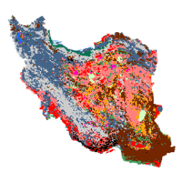
這份伊朗全國地貌圖是透過 Google Earth Engine Cloud 平台處理 Sentinel 圖像所生成。為此,我們處理了超過 2,500 張 Sentinel-1 影像和超過 11,000 張 Sentinel-2 影像,製作出 2017 年的單一鑲嵌資料集。接著,系統會使用大量 13 個類別的參考樣本,訓練以物件為基礎的隨機森林分類方法,生成伊朗全國的土地覆蓋地圖。
頻帶
波段
像素大小:10 公尺 (所有頻段)
| 名稱 | 像素大小 | 說明 |
|---|---|---|
classification |
10 公尺 | 分類 |
分類類別表
| 值 | 顏色 | 說明 |
|---|---|---|
| 1 | #000000 | 都會 |
| 2 | #006eff | 水 |
| 3 | #41a661 | 溼地 |
| 4 | #ff7f7f | 卡魯特 (雅丹) |
| 5 | #bee8ff | Marshland |
| 6 | #ff00c5 | 鹹水之地 |
| 7 | #ff0000 | 黏土 |
| 8 | #00734c | 森林 |
| 9 | #732600 | 露頭 |
| 10 | #ffaa00 | Uncovered Plain |
| 11 | #d3ffbe | 沙 |
| 12 | #446589 | 農地 |
| 13 | #cccccc | Range Land |
使用條款
使用條款
這項作品「Iran Land Cover Map v1 13-class (2017)」由 Arsalan Ghorbanian、Mohammad Kakooei、Meisam Amani、 Sahel Mahdavi、Ali Mohammadzadeh、Mahdi Hasanlou 製作,並已取得 Creative Commons 姓名標示 4.0 國際授權 (CC BY 4.0)
參考資料
參考資料:
Ghorbanian, A.、Kakooei, M.、Amani, M.、Mahdavi, S.、Mohammadzadeh, A.、& Hasanlou, M. (2020). 使用 Google Earth Engine 中的 Sentinel 影像,以及採用遷移訓練樣本的全新自動化土地覆蓋分類工作流程,改善伊朗的土地覆蓋地圖。ISPRS Journal of Photogrammetry and Remote Sensing, 167, 276-288. doi:10.1016/j.isprsjprs.2020.07.013
使用 Earth Engine 探索
程式碼編輯器 (JavaScript)
var dataset = ee.Image('KNTU/LiDARLab/IranLandCover/V1');

var visualization = {
  bands: ['classification']
};

Map.setCenter(54.0, 33.0, 5);

Map.addLayer(dataset, visualization, 'Classification');