
- 資料集開放期間
- 1984-03-16T00:00:00Z–2019-01-01T00:00:00Z
- 資料集產生者
- EC JRC / Google
- 觀測頻率
- 1 年
- 標記
說明
這個資料集包含 1984 年至 2018 年的地表水位置和時間分布情形,以及這些水域的面積和變化統計資料。詳情請參閱相關的期刊文章:全球地表水的高解析度地圖及其長期變化 (2016 年《自然》雜誌) 和線上資料使用者指南。
這些資料是根據 1984 年 3 月 16 日至 2018 年 12 月 31 日期間,從 Landsat 5、7 和 8 取得的 3,865,618 個場景生成。每個像素都使用專家系統個別分類為水 / 非水,並將結果彙整為整個時間範圍和兩個時期 (1984 年至 1999 年、2000 年至 2018 年) 的每月記錄,以偵測變化。
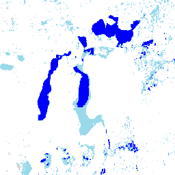
這個「年度季節性分類」集合包含每年水資源季節性的分類,分類依據是全年偵測到的發生次數值。
頻帶
波段
像素大小:30 公尺 (所有頻帶)
| 名稱 | 像素大小 | 說明 |
|---|---|---|
waterClass |
30 公尺 | 全年水資源季節性分類。 |
waterClass 類別表
| 值 | 顏色 | 說明 |
|---|---|---|
| 0 | #cccccc | 無資料 |
| 1 | #ffffff | 非水 |
| 2 | #99d9ea | 季節性水域 |
| 3 | #0000ff | 永久水 |
圖片屬性
影像屬性
| 名稱 | 類型 | 說明 |
|---|---|---|
| 年 | DOUBLE | 年 |
使用條款
使用條款
這裡的所有資料都是在哥白尼計畫下產生,並免費提供,使用不受限制。如需完整的授權資訊,請參閱哥白尼法規。
使用這些資料集的出版品、模型和資料產品必須適當註明出處,包括引用資料集和期刊文章,如下列引文所示。
如要在已發布地圖中使用這項資料做為圖層,請加入下列作者資訊文字:「來源:EC JRC/Google」
參考資料
參考資料:
Jean-Francois Pekel、Andrew Cottam、Noel Gorelick、Alan S. Belward, 全球地表水體及其長期變化的高解析度地圖。 Nature 540, 418-422 (2016)。(doi:10.1038/nature20584)
使用 Earth Engine 探索
程式碼編輯器 (JavaScript)
var dataset = ee.ImageCollection('JRC/GSW1_1/YearlyHistory');

var visualization = {
  bands: ['waterClass'],
  min: 0.0,
  max: 3.0,
  palette: ['cccccc', 'ffffff', '99d9ea', '0000ff']
};

Map.setCenter(59.414, 45.182, 7);

Map.addLayer(dataset, visualization, 'Water Class');