- ความพร้อมใช้งานของชุดข้อมูล
- 2000-01-01T00:00:00Z–2010-12-31T00:00:00Z
- ผู้ผลิตชุดข้อมูล
- NASA LP DAAC ที่ USGS EROS Center
- แผนการสนทนา
- 5 ปี
- แท็ก
คำอธิบาย
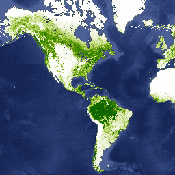
เลเยอร์การปกคลุมของต้นไม้ในฟิลด์พืชพรรณต่อเนื่อง (VCF) ของ Landsat มี ค่าประมาณเปอร์เซ็นต์ของพื้นดินในแนวนอนในแต่ละพิกเซลขนาด 30 ม. ที่ปกคลุม ด้วยพืชพรรณที่เป็นเนื้อไม้ซึ่งมีความสูงมากกว่า 5 เมตร ข้อมูลแสดงถึง ยุคที่กำหนด 3 ยุค ได้แก่ ปี 2000, 2005 และ 2010 ซึ่งรวบรวมจากคอลเล็กชันข้อมูล Landsat ของ NASA/USGS Global Land Survey (GLS) ผลิตภัณฑ์นี้ได้มาจาก แถบทั้ง 7 แถบของ Landsat-5 Thematic Mapper (TM) และ/หรือ Landsat-7 Enhanced Thematic Mapper Plus (ETM+) ทั้งนี้ขึ้นอยู่กับการเลือกรูปภาพ GLS
การปกคลุมของต้นไม้ ซึ่งเป็นพื้นที่ตามสัดส่วนที่ฉายในแนวตั้งของพืชพรรณ (รวมถึงใบ ลำต้น กิ่งก้าน ฯลฯ) ของพืชที่มีเนื้อไม้เหนือความสูงที่กำหนด ส่งผลต่อการแลกเปลี่ยนพลังงานและน้ำบนบก การสังเคราะห์แสงและการคายน้ำ การผลิตขั้นต้นสุทธิ รวมถึงการไหลเวียนของคาร์บอนและสารอาหาร นอกจากนี้ การปกคลุมของต้นไม้ยังส่งผลต่อคุณภาพที่อยู่อาศัยและการเคลื่อนที่ของสัตว์ป่า มูลค่าทรัพย์สินที่อยู่อาศัยสำหรับมนุษย์ และบริการอื่นๆ ของระบบนิเวศ รูปแบบการจัดประเภทอย่างต่อเนื่องของผลิตภัณฑ์ VCF ช่วยให้แสดงการไล่ระดับของสิ่งปกคลุมดินได้ดีกว่ารูปแบบการจัดประเภทแบบแยกส่วนแบบเดิม ที่สำคัญสำหรับการตรวจจับและตรวจสอบการเปลี่ยนแปลงของป่าไม้ (เช่น การตัดไม้ทำลายป่าและการเสื่อมโทรม) การปกคลุมของต้นไม้เป็นคุณลักษณะที่วัดได้ ซึ่งใช้กำหนดการปกคลุมของป่าและการเปลี่ยนแปลง การเปลี่ยนแปลงของพื้นที่ปกคลุมของต้นไม้ เมื่อเวลาผ่านไปสามารถใช้เพื่อตรวจสอบและดึงประวัติการเปลี่ยนแปลงของป่าไม้ในแต่ละพื้นที่ ได้
ชุดข้อมูลนี้สร้างขึ้นสำหรับช่วง 3 ปี ได้แก่ 2000, 2005 และ 2010 โดยมีรูปภาพในคอลเล็กชันสำหรับเส้นทาง/แถว WRS2 ที่พร้อมใช้งานแต่ละรายการ
ย่านความถี่
ย่านความถี่
ขนาดพิกเซล: 30 เมตร (ทุกแถบ)
| ชื่อ | หน่วย | ต่ำสุด | สูงสุด | ขนาดพิกเซล | คำอธิบาย |
|---|---|---|---|---|---|
tree_canopy_cover |
% | 0 | 100 | 30 เมตร | เปอร์เซ็นต์ของพื้นที่พิกเซลที่ปกคลุมด้วยต้นไม้ |
uncertainty |
30 เมตร | RMSE สำหรับ tree-canopy_cover |
|||
source_index |
30 เมตร | ข้อมูลประจำตัวของรูปภาพต้นฉบับที่ใช้สำหรับพิกเซลนั้นๆ นี่คือดัชนี ในอาร์เรย์ข้อมูลเมตาต่อรูปภาพ "แหล่งที่มา" |
พร็อพเพอร์ตี้รูปภาพ
พร็อพเพอร์ตี้รูปภาพ
| ชื่อ | ประเภท | คำอธิบาย |
|---|---|---|
| เส้นทาง | DOUBLE | เส้นทาง |
| เส้นทาง | STRING | เส้นทางและแถว |
| แถว | DOUBLE | แถว |
| แหล่งที่มา | DOUBLE | แหล่งที่มา |
| tree_canopy_cover_class_palette | DOUBLE | จานสีคลาสพื้นที่ที่ร่มไม้ครอบคลุม |
| tree_canopy_cover_class_values | DOUBLE | ค่าคลาสพื้นที่ที่ร่มไม้ครอบคลุม |
| ปี | DOUBLE | ปี |
ข้อกำหนดในการใช้งาน
ข้อกำหนดในการใช้งาน
สิทธิในทรัพย์สินทางปัญญาของชุดข้อมูลนี้เป็นของ University of Maryland, Department of Geographical Sciences และ NASA การใช้งาน ไม่มีค่าใช้จ่ายหากมีการรับทราบ
การอ้างอิง
การอ้างอิงข้อมูล: พื้นที่ที่ร่มไม้ครอบคลุม {ปี, ...} Global Land Cover Facility
การอ้างอิงเอกสาร/วิธีการ: Sexton, J. O., Song, X.-P., Feng, M., Noojipady, P., Anand, A., Huang, C., Kim, D.-H., Collins, K.M., Channan, S., DiMiceli, C., Townshend, J.R.G. (2013). ฟิลด์ต่อเนื่องของพื้นที่ปกคลุมต้นไม้ทั่วโลกที่ความละเอียด 30 ม. โดยการปรับขนาดใหม่ของ MODIS ตาม Landsat ฟิลด์ต่อเนื่องของพืชพรรณที่มีการประมาณข้อผิดพลาดตาม Lidar International Journal of Digital Earth, 130321031236007. doi:10.1080/17538947.2013.786146.
DOI
สำรวจด้วย Earth Engine
ตัวแก้ไขโค้ด (JavaScript)
var dataset = ee.ImageCollection('GLCF/GLS_TCC')
                  .filter(ee.Filter.date('2010-01-01', '2010-12-31'));
var treeCanopyCover = dataset.select('tree_canopy_cover');
var treeCanopyCoverVis = {
  min: 0.0,
  max: 100.0,
  palette: ['ffffff', 'afce56', '5f9c00', '0e6a00', '003800'],
};
Map.setCenter(-88.6, 26.4, 3);
Map.addLayer(treeCanopyCover, treeCanopyCoverVis, 'Tree Canopy Cover');