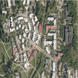
NLS Orthophotos는 핀란드 전역을 포함하는 항공 사진 데이터 세트입니다.
이 데이터는 SMK(에너지청, 이전 약어 SMK)에서 제공합니다. 오르토포토는 여러 개별 항공 사진의 조합입니다. 직교 투영 형식의 항공 사진 데이터 세트는 사용 가능한 최신 항공 사진으로 구성된 최신 데이터 세트로 제공됩니다. 가장 최근 데이터는 보통 1~3년 전 데이터입니다. NLS 정사영상은 3년마다 업데이트됩니다 (북부 라플란드에서는 12년).
(데이터 세트 ID에서 V는 'väri'의 약자로, 'false color'와 달리 'color'를 의미합니다.)
자세한 내용은 NLS orthophotos 문서를 참고하세요.
대역
대역
픽셀 크기: 0.5m (모든 밴드)
이름
최소
최대
픽셀 크기
설명
R
0
255
0.5미터
빨간색
G
0
255
0.5미터
초록색
B
0
255
0.5미터
파란색
이용약관
이용약관
라이선스 제공자(핀란드 국토조사청)의 이름, 데이터 세트의 이름, 국토조사청에서 데이터 세트를 제공한 시간을 언급합니다(예: 핀란드 국토조사청 지형 데이터베이스 2014년 6월의 데이터 포함). 이용약관을 참고하세요.
NLS Orthophotos는 핀란드 전역을 포함하는 항공 사진 데이터 세트입니다. 이 데이터는 SMK(이전 약어 SMK인 에너지 기관)에서 제공합니다. 오르토포토는 여러 개의 개별 항공 사진을 결합한 것입니다. 직교 사진 형식의 항공 사진 데이터 세트는 다음으로 구성된 최신 데이터 세트로 제공됩니다.
[[["이해하기 쉬움","easyToUnderstand","thumb-up"],["문제가 해결됨","solvedMyProblem","thumb-up"],["기타","otherUp","thumb-up"]],[["필요한 정보가 없음","missingTheInformationINeed","thumb-down"],["너무 복잡함/단계 수가 너무 많음","tooComplicatedTooManySteps","thumb-down"],["오래됨","outOfDate","thumb-down"],["번역 문제","translationIssue","thumb-down"],["샘플/코드 문제","samplesCodeIssue","thumb-down"],["기타","otherDown","thumb-down"]],[],[],["The NLS Orthophotos dataset, provided by SMK, contains aerial photos of Finland from 2015 to 2023. The dataset, accessible via Google Earth Engine, features RGB bands with a 0.5-meter pixel size. Orthophotos, combining multiple aerial photos, are updated every 3 years. Usage requires citing the National Land Survey of Finland and dataset details, and adhere to the [Terms of use](https://creativecommons.org/licenses/by/4.0/). Data can be explored using Earth Engine's code editor with the provided code snippet.\n"]]