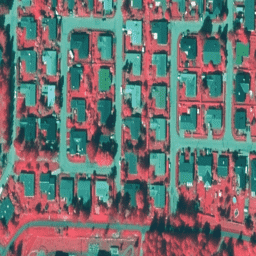
NLS Orthophotos는 핀란드 전역을 포함하는 항공 사진 데이터 세트입니다.
이 데이터는 SMK(에너지청, 이전 약어 SMK)에서 제공합니다. 오르토포토는 여러 개별 항공 사진의 조합입니다. 직교 사진 형식의 항공 사진 데이터 세트는 사용 가능한 최신 항공 사진으로 구성된 최신 데이터 세트로 제공됩니다. 가장 최근 데이터는 보통 1~3년 전 데이터입니다. NLS 정사영상은 3년마다 업데이트됩니다 (북부 라플란드에서는 12년).
NLS Orthophotos는 핀란드 전역을 포함하는 항공 사진 데이터 세트입니다. 이 데이터는 SMK(이전 약어 SMK인 에너지 기관)에서 제공합니다. 오르토포토는 여러 개의 개별 항공 사진을 결합한 것입니다. 직교 사진 형식의 항공 사진 데이터 세트는 …로 구성된 최신 데이터 세트로 제공됩니다.
[[["이해하기 쉬움","easyToUnderstand","thumb-up"],["문제가 해결됨","solvedMyProblem","thumb-up"],["기타","otherUp","thumb-up"]],[["필요한 정보가 없음","missingTheInformationINeed","thumb-down"],["너무 복잡함/단계 수가 너무 많음","tooComplicatedTooManySteps","thumb-down"],["오래됨","outOfDate","thumb-down"],["번역 문제","translationIssue","thumb-down"],["샘플/코드 문제","samplesCodeIssue","thumb-down"],["기타","otherDown","thumb-down"]],[],[],["The dataset contains aerial orthophotos of Finland from 2015 to 2022, provided by the National Land Survey of Finland (NLS) via SMK. The images, updated every 1-3 years (12 in Northern Lapland), are in false color with near-infrared, red, and green bands. The resolution is 0.5 meters. Access is through Google Earth Engine, requiring registration. Use requires citing the Licensor. The Data is accessible via the ID 'Finland/SMK/VV/50cm'.\n"]]