- 資料集開放期間
- 2006-01-01T00:00:00Z–2015-06-10T00:00:00Z
- 資料集產生者
- 全球森林監測 (Global Forest Watch),世界資源研究所 (World Resources Institute)
- 標記
說明
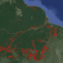
FORMA 是以 MODIS 為基礎的森林砍伐示警系統,適用於潮濕的熱帶森林。FORMA 的設計宗旨是快速找出樹木覆蓋面積減少的新區域。系統會分析 MODIS 感應器每天收集的資料,該感應器在 NASA 的 Terra 和 Aqua 衛星上運作。FORMA 警報系統會偵測植被覆蓋率的顯著變化 (以常態化差異植被指數 (NDVI) 測量),植被覆蓋率的顯著變化可能表示森林遭到砍伐、焚燒或落葉。只要將像素值設為偵測到變更的日期,系統就會在資料集中新增快訊。只有在樹木覆蓋損失機率大於或等於 50% 的區域,才會顯示 FORMA 快訊。FORMA 資料的空間解析度為 500 公尺,更新間隔為每月兩次。FORMA 警報於 2006 年 1 月開始發布。
頻帶
波段
像素大小:500 公尺 (所有頻段)
| 名稱 | 單位 | 最小值 | 最大值 | 像素大小 | 說明 |
|---|---|---|---|---|---|
constant |
秒 | 1.13498e+09* | 1.43392e+09* | 500 公尺 |
使用條款
使用條款
FORMA 資料集為公開,且使用或散布均不受任何限制。WRI 要求使用者適當註明出處,並在適用情況下將 WRI 和 GFW 標示為資料來源。
參考資料
參考資料:
Hammer、Dan、Robin Kraft 和 David Wheeler。2013 年。FORMA 警報。世界資源研究所和全球發展中心。 www.globalforestwatch.org。
使用 Earth Engine 探索
程式碼編輯器 (JavaScript)
var dataset = ee.Image('FORMA/FORMA_500m');

var visualization = {
  bands: ['constant'],
  min: 1134979200.0,
  max: 1433919600.0,
  palette: ['ff0000']
};

Map.setCenter(-51.482, -0.835, 6);

Map.addLayer(dataset, visualization, 'Alert Areas');