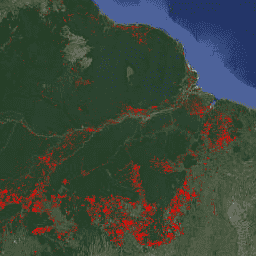
FORMA 是一种基于 MODIS 的热带雨林砍伐警报系统。FORMA 旨在快速识别新的树木覆盖损失区域。该系统会分析 MODIS 传感器每天收集的数据,该传感器在 NASA 的 Terra 和 Aqua 卫星上运行。然后,FORMA 警报系统会检测植被覆盖率随时间推移而发生的显著变化,该变化通过归一化差值植被指数 (NDVI)(一种衡量植被绿度的指标)来衡量。植被覆盖率的这些显著变化可能表明森林正在被砍伐、焚烧或落叶。通过将像素值设置为检测到变化时的日期,将提醒添加到数据集中。FORMA 提醒仅在树木覆盖率损失概率不低于 50% 的区域显示。FORMA 数据的空间分辨率为 500 米,更新间隔为每月两次。FORMA 提醒从 2006 年 1 月开始。
[[["易于理解","easyToUnderstand","thumb-up"],["解决了我的问题","solvedMyProblem","thumb-up"],["其他","otherUp","thumb-up"]],[["没有我需要的信息","missingTheInformationINeed","thumb-down"],["太复杂/步骤太多","tooComplicatedTooManySteps","thumb-down"],["内容需要更新","outOfDate","thumb-down"],["翻译问题","translationIssue","thumb-down"],["示例/代码问题","samplesCodeIssue","thumb-down"],["其他","otherDown","thumb-down"]],[],[],["FORMA, a MODIS-based system, identifies new tree cover loss in humid tropical forests by analyzing daily data from NASA's Terra and Aqua satellites. It uses the Normalized Difference Vegetation Index (NDVI) to detect changes indicative of clearing, burning, or defoliation. Alerts, represented by pixel values set to the change detection date, appear where tree cover loss probability is ≥50%. The data, updated twice-monthly, has a 500-meter spatial resolution and covers January 2006 to June 2015. This data is now deprecated.\n"]]