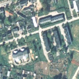
정사영상은 지형 기복, 노출 순간의 지면 대비 카메라 기울기, 카메라 중앙 투영으로 인해 발생하는 왜곡이 제거된 처리된 항공 사진입니다. 디지털 직교사진에는 특정 픽셀 크기 또는 해상도가 있으며, 이는 지상에서 가장 작은 노출 영역 (지상 샘플링 거리, GSD)을 보여줍니다.
오르토포토는 전국을 대상으로 하며 1:5000~1:10000의 축척에 해당합니다 (픽셀 크기 20~40cm). 인구 밀도가 높은 지역의 직교 사진은 10~16cm의 픽셀 크기로 생성됩니다.
RGB 데이터 세트에는 전국을 대상으로 하는 3개의 밴드(빨간색, 녹색, 파란색)가 있습니다.
[[["이해하기 쉬움","easyToUnderstand","thumb-up"],["문제가 해결됨","solvedMyProblem","thumb-up"],["기타","otherUp","thumb-up"]],[["필요한 정보가 없음","missingTheInformationINeed","thumb-down"],["너무 복잡함/단계 수가 너무 많음","tooComplicatedTooManySteps","thumb-down"],["오래됨","outOfDate","thumb-down"],["번역 문제","translationIssue","thumb-down"],["샘플/코드 문제","samplesCodeIssue","thumb-down"],["기타","otherDown","thumb-down"]],[],[],["The dataset contains Estonia's aerial orthophotos from 1993-01-01 to 2021-06-16, provided by the Estonian Land Board. These processed photos, free for commercial and non-commercial use with attribution, have nationwide coverage. Data is available in RGB format (Red, Green, Blue), with pixel sizes ranging from 10-40 cm. Access and visualization are possible via Google Earth Engine using the `ee.ImageCollection(\"Estonia/Maamet/orthos/rgb\")` code snippet. The data includes three bands representing the red, green and blue color.\n"]]