- זמינות קבוצת הנתונים
- 2020-01-01T00:00:00Z–2022-01-01T00:00:00Z
- יוצר מערך הנתונים
- ESA WorldCereal Consortium
- תגים
תיאור
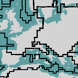
מערכת הסיווג European Space Agency (ESA) WorldCereal מיועדת ליצירת מוצרים תוך חודש מסיום עונת גידול מסוימת. בגלל האופי הדינמי של עונות הגידול האלה ברחבי העולם, בוצעה חלוקה גלובלית לשכבות של אזורים אגרו-אקולוגיים (AEZ) על סמך לוחות הזמנים הגלובליים לגידולים שנוצרו במסגרת הפרויקט [1]. אוסף התכונות במערך הנתונים הזה מכיל את 106 אזורי ה-AEZ שבהם נוצרו מוצרי WorldCereal. לכל אזור AEZ יש לוחות זמנים ייחודיים לגידולים, שמתוארים על סמך תחילת העונה (SOS) וסוף העונה (EOS). התאריכים SOS ו-EOS מצוינים כמספר היום בשנה (DOY). מידע נוסף על הסיווג של אזורי AEZ ועל יצירת המוצר WorldCereal שמתבסס עליו מופיע במקור [2].
מאפייני אזור הזמינות:
- aez_id: המזהה הייחודי של כל אזור AEZ. אפשר לסנן מוצרים של WorldCereal לפי המזהה הזה
- aez_groupid: מזהה הקבוצה משלב כמה אזורים אגרו-אקולוגיים ייחודיים לקבוצה על סמך הדמיון בלוח הזמנים של הגידולים.
- tc-annual_sos: SOS of the tc-annual season (DOY)
- tc-annual_eos: סוף העונה של tc-annual (יום בשנה)
- tc-wintercereals_sos: SOS of the tc-wintercereals season (DOY)
- tc-wintercereals_eos: EOS of the tc-wintercereals season (DOY)
- tc-springcereals_sos: SOS of the tc-springcereals season (DOY)
- tc-springcereals_eos: EOS of the tc-springcereals season (DOY)
- tc-maize-main_sos: SOS of the tc-maize-main season (DOY)
- tc-maize-main_eos: סוף העונה של tc-maize-main (יום בשנה)
- tc-maize-second_sos: SOS of the tc-maize-second season (DOY)
- tc-maize-second_eos: EOS of the tc-maize-second season (DOY)
ערכים חסרים של SOS ו-EOS מציינים היעדר של עונת הגידול המתאימה באזור אקולוגי מסוים.
מקורות מידע:
מערכי נתונים של WorldCereal:
סכימת טבלה
סכימת טבלה
| שם | סוג | תיאור |
|---|---|---|
| aez_id | INT | המזהה הייחודי של אזור הזמינות. |
| aez_groupid | INT | מזהה הקבוצה משלב כמה אזורים אקולוגיים ייחודיים לקבוצה על סמך הדמיון בלוח הזמנים של הגידולים. |
| tc-annual_sos | INT | התאריך של תחילת העונה השנתית (DOY). |
| tc-annual_eos | INT | תאריך הסיום של העונה השנתית של tc (מספר היום בשנה). |
| tc-wintercereals_sos | INT | SOS of the tc-wintercereals season (DOY). |
| tc-wintercereals_eos | INT | תאריך הסיום של עונת הגידול של דגני החורף (יום בשנה). |
| tc-springcereals_sos | INT | SOS of the tc-springcereals season (DOY). |
| tc-springcereals_eos | INT | תאריך הסיום של עונת הגידול של tc-springcereals (מספר היום בשנה). |
| tc-maize-main_sos | INT | SOS of the tc-maize-main season (DOY). |
| tc-maize-main_eos | INT | סוף העונה העיקרית של תירס tc (יום בשנה). |
| tc-maize-second_sos | INT | SOS of the tc-maize-second season (DOY). |
| tc-maize-second_eos | INT | תאריך הסיום של העונה השנייה של tc-maize (מספר היום בשנה). |
תנאים והגבלות
תנאים והגבלות
ציטוטים ביבליוגרפיים
Van Tricht, K., Degerickx, J., Gilliams, S., Zanaga, D., Battude, M., Grosu, A., Brombacher, J., Lesiv, M., Bayas, J. ג. L., Karanam, S., Fritz, S., Becker-Reshef, I., Franch, B., Mollà-Bononad, B., Boogaard, H., Pratihast, A. K., and Szantoi, Z.: WorldCereal: מערכת דינמית בקוד פתוח למיפוי עונתי של גידולים והשקיה בקנה מידה גלובלי, Earth Syst. Sci. Data Discuss. [preprint], doi:10.5194/essd-2023-184, in review, 2023.,
מזהי DOI
סיור עם פלטפורמת Earth Engine
Code Editor (JavaScript)
var aez = ee.FeatureCollection('ESA/WorldCereal/AEZ/v100');

// Find the AEZs with multiple growing seasons for maize and cereal.
var twoMaizeAez =
    aez.filter(ee.Filter.notNull(['tc-maize-main_eos', 'tc-maize-second_eos']));
var twoCerealAez = aez.filter(
    ee.Filter.notNull(['tc-wintercereals_eos', 'tc-springcereals_eos']));

Map.addLayer(
    twoMaizeAez.draw('ff0000', 1, 2), {}, 'AEZ with two maize seasons');
Map.addLayer(
    twoCerealAez.draw('0000ff', 1, 2), {}, 'AEZ with two cereal seasons');
ויזואליזציה כ-FeatureView
FeatureView הוא ייצוג מואץ של FeatureCollection לצפייה בלבד. פרטים נוספים ניתן לקרוא ב
מסמכי התיעוד של FeatureView.
Code Editor (JavaScript)
var aezLayer = ui.Map.FeatureViewLayer('ESA/WorldCereal/AEZ/v100_FeatureView');
var visParams = {
  opacity: 0.5,
  lineWidth: 5,
  polygonFillColor: 'red'
};

aezLayer.setVisParams(visParams);
aezLayer.setName('Agro-Ecological Zones');

Map.setCenter(15.5, 35.5, 3);
Map.add(aezLayer);