- ডেটাসেটের প্রাপ্যতা
- ১৯৫০-০১-০১T০১:০০:০০Z–২০২৬-০৭-০৭T২২:০০:০০Z
- ডেটাসেট প্রযোজক
- কোপারনিকাস জলবায়ু ডেটা স্টোর
- ক্যাডেন্স
- ১ ঘন্টা
- ট্যাগ
বর্ণনা
ERA5-Land হলো একটি পুনঃবিশ্লেষণ ডেটাসেট যা ERA5-এর তুলনায় উন্নত রেজোলিউশনে কয়েক দশক ধরে ভূমির চলকগুলোর বিবর্তনের একটি সামঞ্জস্যপূর্ণ চিত্র প্রদান করে। ECMWF ERA5 জলবায়ু পুনঃবিশ্লেষণের ভূমি উপাদানটিকে পুনরায় চালনা করে ERA5-Land তৈরি করা হয়েছে। পুনঃবিশ্লেষণ পদার্থবিজ্ঞানের সূত্র ব্যবহার করে মডেল ডেটার সাথে বিশ্বজুড়ে প্রাপ্ত পর্যবেক্ষণকে একত্রিত করে একটি বিশ্বব্যাপী সম্পূর্ণ এবং সামঞ্জস্যপূর্ণ ডেটাসেট তৈরি করে। পুনঃবিশ্লেষণ এমন ডেটা তৈরি করে যা কয়েক দশক আগের সময় পর্যন্ত বিস্তৃত, যা অতীতের জলবায়ুর একটি সঠিক বিবরণ প্রদান করে। এই ডেটাসেটটিতে CDS-এ উপলব্ধ সমস্ত ৫০টি চলক অন্তর্ভুক্ত রয়েছে।
ERA5-Land ডেটা ১৯৫০ সাল থেকে রিয়েল-টাইমের তিন মাস পর্যন্ত পাওয়া যায়।
অনুগ্রহ করে ERA5-Land-এর "Known Issues" অংশটি দেখুন। বিশেষ করে, লক্ষ্য করুন যে মোট বাষ্পীভবনের তিনটি উপাদানের মান নিম্নরূপভাবে অদলবদল করা হয়েছে:
- 'অনাবৃত মাটি থেকে বাষ্পীভবন' (মার্স প্যারামিটার কোড 228101 (evabs)) চলকটির মান, 'উদ্ভিদের প্রস্বেদন থেকে বাষ্পীভবন' (মার্স প্যারামিটার 228103 (evavt)) চলকটির মানের অনুরূপ।
- "মহাসাগর ব্যতীত উন্মুক্ত জলাশয় থেকে বাষ্পীভবন" (মঙ্গল গ্রহের প্যারামিটার কোড 228102 (evaow)) চলকটির মান, "অনাবৃত মাটি থেকে বাষ্পীভবন" (মঙ্গল গ্রহের প্যারামিটার কোড 228101 (evabs)) চলকটির মানের অনুরূপ।
- "উদ্ভিদের প্রস্বেদন থেকে বাষ্পীভবন" (মঙ্গল গ্রহের প্যারামিটার কোড 228103 (evavt)) চলকটির মান, "মহাসাগর ব্যতীত উন্মুক্ত জলাশয় থেকে বাষ্পীভবন" (মঙ্গল গ্রহের প্যারামিটার কোড 228102 (evaow)) চলকটির মানের অনুরূপ।
অনুগ্রহ করে মনে রাখবেন যে ERA5-Land-এ ব্যবহৃত সঞ্চয়নের রীতি ERA5-এর থেকে ভিন্ন। এই সঞ্চয়নগুলোকে ERA-Interim বা ERA-Interim/Land-এর মতোই বিবেচনা করা হয়, অর্থাৎ, পূর্বাভাসের শুরু থেকে পূর্বাভাস ধাপের শেষ পর্যন্ত এগুলো সঞ্চিত হয়। এটি প্রতিদিনের মধ্যেই ঘটে এবং মধ্যরাতে রিসেট হয়ে যায়। আরও তথ্যের জন্য এই পৃষ্ঠাটি দেখুন । আর্থ ইঞ্জিন ডেটা টিম ১৯টি অতিরিক্ত ব্যান্ড যুক্ত করেছে, প্রতিটি সঞ্চয়ন ব্যান্ডের জন্য একটি করে, যেখানে প্রতি ঘণ্টার মান দুটি পরপর পূর্বাভাস ধাপের পার্থক্য হিসাবে গণনা করা হয়।
ব্যান্ড
ব্যান্ড
পিক্সেল সাইজ: ১১১৩২ মিটার (সকল ব্যান্ড)
| নাম | ইউনিট | পিক্সেল আকার | বর্ণনা |
|---|---|---|---|
dewpoint_temperature_2m | কে | ১১১৩২ মিটার | ভূপৃষ্ঠ থেকে ২ মিটার উপরে থাকা বাতাসকে যে তাপমাত্রায় শীতল করলে সম্পৃক্ত অবস্থা তৈরি হয়, তাকেই শিশিরবিন্দু তাপমাত্রা বলে। এটি বায়ুর আর্দ্রতার একটি পরিমাপ। তাপমাত্রা ও চাপের সাথে মিলিতভাবে এটি ব্যবহার করে আপেক্ষিক আর্দ্রতা গণনা করা যায়। বায়ুমণ্ডলীয় পরিস্থিতি বিবেচনায় নিয়ে, মডেলের সর্বনিম্ন স্তর এবং ভূপৃষ্ঠের মধ্যে ইন্টারপোলেশনের মাধ্যমে ২ মিটার শিশিরবিন্দু তাপমাত্রা গণনা করা হয়। |
temperature_2m | কে | ১১১৩২ মিটার | স্থলভাগ, সমুদ্র বা অভ্যন্তরীণ জলাশয়ের পৃষ্ঠ থেকে ২ মিটার উপরে বায়ুর তাপমাত্রা। বায়ুমণ্ডলীয় পরিস্থিতি বিবেচনায় নিয়ে, মডেলের সর্বনিম্ন স্তর এবং পৃথিবীর পৃষ্ঠের মধ্যে ইন্টারপোলেশনের মাধ্যমে ২ মিটার তাপমাত্রা গণনা করা হয়। |
skin_temperature | কে | ১১১৩২ মিটার | পৃথিবীর পৃষ্ঠের তাপমাত্রা। পৃষ্ঠীয় তাপমাত্রা হলো সেই তাত্ত্বিক তাপমাত্রা যা পৃষ্ঠীয় শক্তির ভারসাম্য বজায় রাখার জন্য প্রয়োজন। এটি ভূপৃষ্ঠের সর্ব্বোচ্চ স্তরের তাপমাত্রাকে বোঝায়, যার কোনো তাপ ধারণ ক্ষমতা নেই এবং তাই এটি পৃষ্ঠীয় প্রবাহের পরিবর্তনে তাৎক্ষণিকভাবে সাড়া দিতে পারে। স্থলভাগ এবং সমুদ্রের উপর পৃষ্ঠীয় তাপমাত্রা ভিন্নভাবে গণনা করা হয়। |
soil_temperature_level_1 | কে | ১১১৩২ মিটার | ECMWF ইন্টিগ্রেটেড ফোরকাস্টিং সিস্টেমের স্তর ১ (০ - ৭ সেমি)-এর মাটির তাপমাত্রা। ভূপৃষ্ঠ ০ সেমি-তে অবস্থিত। মাটির তাপমাত্রা প্রতিটি স্তরের মাঝখানে নির্ধারণ করা হয় এবং তাদের মধ্যবর্তী সংযোগস্থলে তাপ স্থানান্তর গণনা করা হয়। এটি ধরে নেওয়া হয় যে সর্বনিম্ন স্তরের তলদেশ থেকে কোনো তাপ স্থানান্তর হয় না। |
soil_temperature_level_2 | কে | ১১১৩২ মিটার | ECMWF সমন্বিত পূর্বাভাস সিস্টেমের ২ নং স্তরের (৭-২৮ সেমি) মাটির তাপমাত্রা। |
soil_temperature_level_3 | কে | ১১১৩২ মিটার | ECMWF সমন্বিত পূর্বাভাস সিস্টেমের ৩ নং স্তরের (২৮-১০০ সেমি) মাটির তাপমাত্রা। |
soil_temperature_level_4 | কে | ১১১৩২ মিটার | ECMWF সমন্বিত পূর্বাভাস সিস্টেমের স্তর ৪ (১০০-২৮৯ সেমি)-এর মাটির তাপমাত্রা। |
lake_bottom_temperature | কে | ১১১৩২ মিটার | অভ্যন্তরীণ জলাশয় (হ্রদ, জলাধার, নদী) এবং উপকূলীয় জলের তলদেশের তাপমাত্রা। ইন্টিগ্রেটেড ফোরকাস্টিং সিস্টেমে বিশ্বের সমস্ত প্রধান অভ্যন্তরীণ জলাশয়ের জলের তাপমাত্রা এবং হ্রদের বরফকে উপস্থাপন করার জন্য ECMWF ২০১৫ সালের মে মাসে একটি হ্রদ মডেল চালু করে। এই মডেলটি সময়ের সাথে সাথে হ্রদের গভীরতা এবং পৃষ্ঠের ক্ষেত্রফল (বা আংশিক আচ্ছাদন) স্থির রাখে। |
lake_ice_depth | এম | ১১১৩২ মিটার | অভ্যন্তরীণ জলাশয় (হ্রদ, জলাধার ও নদী) এবং উপকূলীয় জলের উপর বরফের পুরুত্ব। ইসিএমডব্লিউএফ ইন্টিগ্রেটেড ফোরকাস্টিং সিস্টেম (আইএফএস) অভ্যন্তরীণ জলাশয় (হ্রদ, জলাধার ও নদী) এবং উপকূলীয় জলের উপর বরফ গঠন ও গলনকে উপস্থাপন করে। এখানে একটি একক বরফের স্তরকে দেখানো হয়। এই প্যারামিটারটি হলো সেই বরফের স্তরের পুরুত্ব। |
lake_ice_temperature | কে | ১১১৩২ মিটার | অভ্যন্তরীণ জলাশয় (হ্রদ, জলাধার, নদী) এবং উপকূলীয় জলের বরফের উপরিভাগের তাপমাত্রা। ECMWF ইন্টিগ্রেটেড ফোরকাস্টিং সিস্টেম হ্রদের উপর বরফ গঠন এবং গলন উপস্থাপন করে। এখানে একটি একক বরফের স্তর দেখানো হয়। |
lake_mix_layer_depth | এম | ১১১৩২ মিটার | অভ্যন্তরীণ জলাশয় (হ্রদ, জলাধার এবং নদী) বা উপকূলীয় জলের সবচেয়ে উপরের স্তরের পুরুত্ব, যা ভালোভাবে মিশ্রিত এবং যার তাপমাত্রা গভীরতার সাথে প্রায় স্থির থাকে (তাপমাত্রার অভিন্ন বন্টন)। ECMWF ইন্টিগ্রেটেড ফোরকাস্টিং সিস্টেম অভ্যন্তরীণ জলাশয়গুলোকে উল্লম্বভাবে দুটি স্তর দ্বারা উপস্থাপন করে: উপরে মিশ্র স্তর এবং নিচে থার্মোক্লাইন। থার্মোক্লাইনের উপরের সীমানা মিশ্র স্তরের তলদেশে এবং নিচের সীমানা হ্রদের তলদেশে অবস্থিত। মিশ্র স্তরের মধ্যে মিশ্রণ ঘটতে পারে যখন পৃষ্ঠের (এবং পৃষ্ঠের কাছাকাছি) জলের ঘনত্ব নিচের জলের ঘনত্বের চেয়ে বেশি হয়। হ্রদের পৃষ্ঠে বাতাসের ক্রিয়ার মাধ্যমেও মিশ্রণ ঘটতে পারে। |
lake_mix_layer_temperature | কে | ১১১৩২ মিটার | অভ্যন্তরীণ জলাশয় (হ্রদ, জলাধার এবং নদী) বা উপকূলীয় জলের সবচেয়ে উপরের স্তরের তাপমাত্রা, যা ভালোভাবে মিশ্রিত থাকে। ECMWF ইন্টিগ্রেটেড ফোরকাস্টিং সিস্টেম অভ্যন্তরীণ জলাশয়গুলোকে উল্লম্বভাবে দুটি স্তরে উপস্থাপন করে: উপরে মিশ্র স্তর এবং নিচে থার্মোক্লাইন। থার্মোক্লাইনের উপরের সীমানা মিশ্র স্তরের তলদেশে এবং নিচের সীমানা হ্রদের তলদেশে অবস্থিত। মিশ্র স্তরের মধ্যে মিশ্রণ ঘটতে পারে যখন পৃষ্ঠের (এবং পৃষ্ঠের কাছাকাছি) জলের ঘনত্ব নিচের জলের ঘনত্বের চেয়ে বেশি হয়। হ্রদের পৃষ্ঠে বাতাসের ক্রিয়ার মাধ্যমেও মিশ্রণ ঘটতে পারে। |
lake_shape_factor | ১১১৩২ মিটার | এই প্যারামিটারটি অভ্যন্তরীণ জলাশয় (হ্রদ, জলাধার এবং নদী) এবং উপকূলীয় জলের থার্মোক্লাইন স্তরে গভীরতার সাথে তাপমাত্রার পরিবর্তন পদ্ধতি বর্ণনা করে। এটি হ্রদের তলদেশের তাপমাত্রা এবং হ্রদ-সম্পর্কিত অন্যান্য প্যারামিটার গণনা করতে ব্যবহৃত হয়। ECMWF ইন্টিগ্রেটেড ফোরকাস্টিং সিস্টেম অভ্যন্তরীণ এবং উপকূলীয় জলাশয়গুলিকে উল্লম্বভাবে দুটি স্তরের মাধ্যমে উপস্থাপন করে: উপরে মিশ্র স্তর এবং নীচে থার্মোক্লাইন, যেখানে গভীরতার সাথে তাপমাত্রার পরিবর্তন ঘটে। | |
lake_total_layer_temperature | কে | ১১১৩২ মিটার | অভ্যন্তরীণ জলাশয় (হ্রদ, জলাধার ও নদী) এবং উপকূলীয় জলের মোট জলস্তম্ভের গড় তাপমাত্রা। ECMWF ইন্টিগ্রেটেড ফোরকাস্টিং সিস্টেম অভ্যন্তরীণ জলাশয়গুলোকে উল্লম্বভাবে দুটি স্তরে উপস্থাপন করে: উপরে মিশ্র স্তর এবং নিচে থার্মোক্লাইন, যেখানে গভীরতার সাথে তাপমাত্রার পরিবর্তন ঘটে। এই প্যারামিটারটি হলো দুটি স্তরের গড়। |
snow_albedo | ১১১৩২ মিটার | একে সৌর বর্ণালীর মধ্যে, প্রত্যক্ষ এবং বিক্ষিপ্ত উভয় প্রকার বিকিরণের ক্ষেত্রে, বরফ দ্বারা প্রতিফলিত সৌর (স্বল্পতরঙ্গ) বিকিরণের ভগ্নাংশ হিসাবে সংজ্ঞায়িত করা হয়। এটি বরফে আচ্ছাদিত গ্রিড সেলগুলির প্রতিফলন ক্ষমতার একটি পরিমাপ। এর মান ০ থেকে ১-এর মধ্যে পরিবর্তিত হয়। সাধারণত, ০.৮ বা তার বেশি অ্যালবেডো মানের ক্ষেত্রে বরফ ও তুষারের প্রতিফলন ক্ষমতা বেশি থাকে। | |
snow_cover | ১১১৩২ মিটার | এটি সেল / গ্রিড-বক্সের যে অংশ বরফ দ্বারা আবৃত, তার ভগ্নাংশ (০-১) নির্দেশ করে (যা ERA5-এর মেঘাচ্ছন্নতার ক্ষেত্রের অনুরূপ)। | |
snow_density | কেজি/মি^৩ | ১১১৩২ মিটার | তুষার স্তরে প্রতি ঘনমিটারে তুষারের ভর। ECMWF ইন্টিগ্রেটেড ফোরকাস্ট সিস্টেম (IFS) মডেলটি তুষারকে মাটির সর্ববৃহৎ স্তরের উপরে একটি একক অতিরিক্ত স্তর হিসেবে দেখায়। তুষার গ্রিড বক্সের সম্পূর্ণ বা আংশিক অংশকে আবৃত করতে পারে। |
snow_depth | এম | ১১১৩২ মিটার | ভূমিতে থাকা বরফের পুরুত্বের তাৎক্ষণিক গ্রিড-বক্স গড় (গাছের পাতার উপরের বরফ বাদে)। |
snow_depth_water_equivalent | জলের সমতুল্য মিটার | ১১১৩২ মিটার | একটি গ্রিড বক্সের তুষারাবৃত এলাকা থেকে পরিমাপকৃত তুষারের গভীরতা। এর একক হলো মিটার ওয়াটার ইকুইভ্যালেন্ট (জল সমতুল্য), অর্থাৎ, তুষার গলে গিয়ে পুরো গ্রিড বক্স জুড়ে সমানভাবে ছড়িয়ে পড়লে জলের যে গভীরতা হতো, এটি সেই গভীরতা। ECMWF ইন্টিগ্রেটেড ফোরকাস্ট সিস্টেম তুষারকে মাটির সর্ব্বোচ্চ স্তরের উপরে একটি একক অতিরিক্ত স্তর হিসেবে দেখায়। তুষার গ্রিড বক্সের সম্পূর্ণ বা আংশিক অংশকে আবৃত করতে পারে। |
snowfall | জলের সমতুল্য মিটার | ১১১৩২ মিটার | পৃথিবীর পৃষ্ঠে পতিত মোট সঞ্চিত তুষার। এটি বৃহৎ-মাপের বায়ুমণ্ডলীয় প্রবাহ (অনুভূমিক মাপ প্রায় কয়েকশ মিটারের বেশি) এবং পরিচলনের কারণে সৃষ্ট তুষার নিয়ে গঠিত, যেখানে উষ্ণ বায়ুর ক্ষুদ্রতর মাপের এলাকা (প্রায় ৫ কিমি থেকে কয়েকশ কিলোমিটার) উপরে ওঠে। যে সময়কালে এই চলকটি সঞ্চিত হয়েছে, সেই সময়ের মধ্যে যদি তুষার গলে যায়, তবে এর পরিমাণ তুষারের গভীরতার চেয়ে বেশি হবে। এই চলকটি হলো পূর্বাভাসের সময় শুরু থেকে পূর্বাভাসের ধাপ শেষ পর্যন্ত সঞ্চিত মোট জলের পরিমাণ। প্রদত্ত এককগুলো পরিমাপ করে যে, তুষার গলে গ্রিড বক্সের উপর সমানভাবে ছড়িয়ে পড়লে জলের গভীরতা কত হতো। মডেলের চলকগুলোর সাথে পর্যবেক্ষণের তুলনা করার সময় সতর্কতা অবলম্বন করা উচিত, কারণ পর্যবেক্ষণগুলো প্রায়শই একটি মডেল গ্রিড বক্স এবং মডেল টাইম স্টেপের গড় প্রতিনিধিত্ব না করে, স্থান ও সময়ের একটি নির্দিষ্ট বিন্দুর স্থানীয় হয়ে থাকে। |
snowmelt | জলের সমতুল্য মিটার | ১১১৩২ মিটার | গ্রিড বক্স জুড়ে তুষার গলনের গড় (তুষারের উপর গলন বের করতে, তুষার ভগ্নাংশ দিয়ে ভাগ করুন)। এই চলকটি পূর্বাভাসের সময় শুরু থেকে পূর্বাভাস ধাপের শেষ পর্যন্ত সঞ্চিত হয়। |
temperature_of_snow_layer | কে | ১১১৩২ মিটার | এই চলকটি ভূমি থেকে তুষার-বায়ু সংযোগস্থল পর্যন্ত তুষার স্তরের তাপমাত্রা নির্দেশ করে। ECMWF ইন্টিগ্রেটেড ফোরকাস্ট সিস্টেম (IFS) মডেলটি তুষারকে মাটির সর্ববৃহৎ স্তরের উপর একটি একক অতিরিক্ত স্তর হিসেবে উপস্থাপন করে। তুষার গ্রিড বক্সের সম্পূর্ণ বা আংশিক অংশকে আবৃত করতে পারে। |
skin_reservoir_content | জলের সমতুল্য মিটার | ১১১৩২ মিটার | উদ্ভিদের পাতার আচ্ছাদনে এবং/অথবা মাটির উপর একটি পাতলা স্তরে থাকা জলের পরিমাণ। এটি উদ্ভিদের পাতা দ্বারা আটকে থাকা বৃষ্টির জল এবং শিশির থেকে আসা জলের পরিমাণকে বোঝায়। একটি গ্রিড বক্সে সর্বোচ্চ কী পরিমাণ 'ত্বকীয় জলাধার' থাকতে পারে তা উদ্ভিদের ধরনের উপর নির্ভর করে এবং এর পরিমাণ শূন্যও হতে পারে। বাষ্পীভবনের মাধ্যমে জল এই 'ত্বকীয় জলাধার' থেকে বেরিয়ে যায়। |
volumetric_soil_water_layer_1 | আয়তন ভগ্নাংশ | ১১১৩২ মিটার | ECMWF সমন্বিত পূর্বাভাস সিস্টেমের মাটির স্তর ১ (০ - ৭ সেমি)-এ থাকা পানির পরিমাণ। ভূপৃষ্ঠ ০ সেমি-তে অবস্থিত। মাটির পানির আয়তন মাটির বুনন (বা শ্রেণিবিভাগ), মাটির গভীরতা এবং এর নিচের ভূগর্ভস্থ পানির স্তরের সাথে সম্পর্কিত। |
volumetric_soil_water_layer_2 | আয়তন ভগ্নাংশ | ১১১৩২ মিটার | ECMWF সমন্বিত পূর্বাভাস সিস্টেমের মাটির স্তর ২ (৭-২৮ সেমি)-এ পানির পরিমাণ। |
volumetric_soil_water_layer_3 | আয়তন ভগ্নাংশ | ১১১৩২ মিটার | ECMWF সমন্বিত পূর্বাভাস সিস্টেমের মাটির ৩ নং স্তর (২৮-১০০ সেমি)-এ থাকা পানির পরিমাণ। |
volumetric_soil_water_layer_4 | আয়তন ভগ্নাংশ | ১১১৩২ মিটার | ECMWF সমন্বিত পূর্বাভাস সিস্টেমের মাটির স্তর ৪ (১০০-২৮৯ সেমি)-এ পানির পরিমাণ। |
forecast_albedo | ১১১৩২ মিটার | এটি পৃথিবীর পৃষ্ঠের প্রতিফলন ক্ষমতার একটি পরিমাপ। এটি হলো সৌর বর্ণালীর মধ্যে, সরাসরি এবং বিক্ষিপ্ত উভয় প্রকার বিকিরণের ক্ষেত্রে, পৃথিবীর পৃষ্ঠ দ্বারা প্রতিফলিত সৌর (স্বল্পতরঙ্গ) বিকিরণের ভগ্নাংশ। এর মান ০ থেকে ১-এর মধ্যে থাকে। সাধারণত, বরফ ও তুষারের প্রতিফলন ক্ষমতা বেশি থাকে, যাদের অ্যালবেডোর মান ০.৮ বা তার বেশি; ভূমির ক্ষেত্রে এর মান প্রায় ০.১ থেকে ০.৪-এর মধ্যে এবং মহাসাগরের ক্ষেত্রে এর মান ০.১ বা তার কম। সূর্য থেকে আসা বিকিরণ (সৌর বা স্বল্পতরঙ্গ বিকিরণ) আংশিকভাবে মেঘ এবং বায়ুমণ্ডলের কণা (এরোসল) দ্বারা মহাকাশে প্রতিফলিত হয় এবং এর কিছু অংশ শোষিত হয়। বাকি অংশ পৃথিবীর পৃষ্ঠে আপতিত হয়, যেখানে এর কিছু অংশ প্রতিফলিত হয়। পৃথিবীর পৃষ্ঠ দ্বারা প্রতিফলিত অংশের পরিমাণ অ্যালবেডোর উপর নির্ভর করে। ECMWF ইন্টিগ্রেটেড ফোরকাস্টিং সিস্টেম (IFS)-এ একটি জলবায়ুগত পটভূমি অ্যালবেডো (কয়েক বছরের গড় পর্যবেক্ষণকৃত মান) ব্যবহার করা হয়, যা মডেল দ্বারা জল, বরফ এবং তুষারের উপর পরিবর্তিত হয়। অ্যালবেডো প্রায়শই শতাংশ (%) হিসাবে দেখানো হয়। | |
surface_latent_heat_flux | J/m^2 | ১১১৩২ মিটার | অশান্ত ব্যাপনের মাধ্যমে পৃষ্ঠের সাথে সুপ্ত তাপের বিনিময়। এই চলকটি পূর্বাভাসের সময় শুরু থেকে পূর্বাভাস ধাপের শেষ পর্যন্ত সঞ্চিত হয়। মডেলের প্রচলিত নিয়ম অনুসারে, নিম্নগামী প্রবাহ ধনাত্মক। |
surface_net_solar_radiation | J/m^2 | ১১১৩২ মিটার | পৃথিবীর পৃষ্ঠে পৌঁছানো সৌর বিকিরণের (যা শর্টওয়েভ বিকিরণ নামেও পরিচিত) পরিমাণ (সরাসরি এবং বিক্ষিপ্ত উভয়ই) থেকে পৃথিবীর পৃষ্ঠ দ্বারা প্রতিফলিত বিকিরণের পরিমাণ (যা অ্যালবেডো দ্বারা নিয়ন্ত্রিত হয়) বিয়োগ করলে যা পাওয়া যায়, তাকেই ভূপৃষ্ঠের নিট সৌর বিকিরণ বলা হয়। সূর্য থেকে আসা বিকিরণ (সৌর বা শর্টওয়েভ বিকিরণ) আংশিকভাবে মেঘ এবং বায়ুমণ্ডলের কণা (এরোসল) দ্বারা মহাকাশে প্রতিফলিত হয় এবং এর কিছু অংশ শোষিত হয়। বাকি অংশ পৃথিবীর পৃষ্ঠে আপতিত হয়, যেখানে এর কিছু অংশ প্রতিফলিত হয়। নিম্নগামী এবং প্রতিফলিত সৌর বিকিরণের পার্থক্যই হলো ভূপৃষ্ঠের মোট সৌর বিকিরণ। এই চলকটি পূর্বাভাসের সময় শুরু থেকে পূর্বাভাস ধাপের শেষ পর্যন্ত সঞ্চিত হয়। এর একক হলো জুল প্রতি বর্গমিটার (J m-2)। ওয়াট প্রতি বর্গমিটারে (W m-2) রূপান্তর করতে, সঞ্চিত মানগুলোকে সেকেন্ডে প্রকাশিত সঞ্চয়ন সময়কাল দ্বারা ভাগ করতে হবে। উল্লম্ব ফ্লাক্সের জন্য ECMWF-এর প্রচলিত নিয়ম অনুযায়ী, নিচের দিকে ফ্লাক্স ধনাত্মক ধরা হয়। |
surface_net_thermal_radiation | J/m^2 | ১১১৩২ মিটার | পৃষ্ঠে মোট তাপীয় বিকিরণ। পূর্বাভাসের সময় শুরু থেকে পূর্বাভাস ধাপের শেষ পর্যন্ত সঞ্চিত ক্ষেত্র। মডেলের প্রচলিত নিয়ম অনুযায়ী নিম্নগামী ফ্লাক্স ধনাত্মক। |
surface_sensible_heat_flux | J/m^2 | ১১১৩২ মিটার | অশান্ত বায়ুপ্রবাহের প্রভাবে পৃথিবীর পৃষ্ঠ এবং বায়ুমণ্ডলের মধ্যে তাপের স্থানান্তর (তবে ঘনীভবন বা বাষ্পীভবনের ফলে সৃষ্ট কোনো তাপ স্থানান্তর এর অন্তর্ভুক্ত নয়)। বোধগম্য তাপ প্রবাহের মাত্রা পৃষ্ঠ এবং তার উপরের বায়ুমণ্ডলের তাপমাত্রার পার্থক্য, বাতাসের গতি এবং পৃষ্ঠের অমসৃণতা দ্বারা নিয়ন্ত্রিত হয়। উদাহরণস্বরূপ, একটি উষ্ণ পৃষ্ঠের উপর শীতল বায়ু থাকলে তা স্থলভাগ (বা মহাসাগর) থেকে বায়ুমণ্ডলে একটি বোধগম্য তাপ প্রবাহ তৈরি করবে। এটি একটি একক স্তরের চলক এবং এটি পূর্বাভাসের সময় শুরু থেকে পূর্বাভাস ধাপের শেষ পর্যন্ত সঞ্চিত হয়। এর একক হলো জুল প্রতি বর্গমিটার (J m-2)। ওয়াট প্রতি বর্গমিটারে (W m-2) রূপান্তর করতে, সঞ্চিত মানগুলিকে সেকেন্ডে প্রকাশিত সঞ্চয়ন সময়কাল দ্বারা ভাগ করতে হবে। উল্লম্ব প্রবাহের জন্য ECMWF-এর প্রচলিত নিয়ম অনুযায়ী, নিচের দিকে প্রবাহ ধনাত্মক। |
surface_solar_radiation_downwards | J/m^2 | ১১১৩২ মিটার | পৃথিবীর পৃষ্ঠে পৌঁছানো সৌর বিকিরণের (যা শর্টওয়েভ বিকিরণ নামেও পরিচিত) পরিমাণ। এই চলকটি সরাসরি এবং বিক্ষিপ্ত উভয় প্রকার সৌর বিকিরণ নিয়ে গঠিত। সূর্য থেকে আসা বিকিরণ (সৌর বা শর্টওয়েভ বিকিরণ) বায়ুমণ্ডলের মেঘ এবং কণা (এরোসল) দ্বারা আংশিকভাবে মহাকাশে প্রতিফলিত হয় এবং এর কিছু অংশ শোষিত হয়। বাকি অংশ পৃথিবীর পৃষ্ঠে আপতিত হয় (যা এই চলক দ্বারা উপস্থাপিত)। মোটামুটি ভালো আনুমানিক হিসাবে, এই চলকটি হলো ভূপৃষ্ঠে একটি পাইরানোমিটার (সৌর বিকিরণ পরিমাপের জন্য ব্যবহৃত একটি যন্ত্র) দ্বারা পরিমাপ করা মানের মডেল সমতুল্য। তবে, মডেলের চলকগুলোর সাথে পর্যবেক্ষণের তুলনা করার সময় সতর্কতা অবলম্বন করা উচিত, কারণ পর্যবেক্ষণগুলো প্রায়শই একটি মডেল গ্রিড বক্স এবং মডেল টাইম স্টেপের গড় উপস্থাপন না করে, স্থান ও সময়ের একটি নির্দিষ্ট বিন্দুর স্থানীয় হয়ে থাকে। এই চলকটি পূর্বাভাসের সময় শুরু থেকে পূর্বাভাসের ধাপ শেষ পর্যন্ত সঞ্চিত হয়। এর একক হলো জুল প্রতি বর্গমিটার (J m-2)। ওয়াট প্রতি বর্গমিটারে (W m-2) রূপান্তর করতে, সঞ্চিত মানগুলোকে সেকেন্ডে প্রকাশিত সঞ্চয়ন সময়কাল দ্বারা ভাগ করতে হবে। উল্লম্ব ফ্লাক্সের ক্ষেত্রে ECMWF প্রথা অনুযায়ী নিম্নমুখী ফ্লাক্স ধনাত্মক। |
surface_thermal_radiation_downwards | J/m^2 | ১১১৩২ মিটার | বায়ুমণ্ডল এবং মেঘ থেকে নির্গত তাপীয় (যা দীর্ঘতরঙ্গ বা ভূ-পৃষ্ঠীয় বিকিরণ নামেও পরিচিত) বিকিরণের যে পরিমাণ পৃথিবীর পৃষ্ঠে পৌঁছায়। পৃথিবীর পৃষ্ঠ থেকে তাপীয় বিকিরণ নির্গত হয়, যার কিছু অংশ বায়ুমণ্ডল এবং মেঘ দ্বারা শোষিত হয়। একইভাবে বায়ুমণ্ডল এবং মেঘ সব দিকে তাপীয় বিকিরণ নির্গত করে, যার কিছু অংশ পৃষ্ঠে পৌঁছায় (যা এই চলক দ্বারা প্রকাশ করা হয়)। এই চলকটি পূর্বাভাসের সময় শুরু থেকে পূর্বাভাসের ধাপ শেষ পর্যন্ত সঞ্চিত হয়। এর একক হলো জুল প্রতি বর্গমিটার (J m-2)। ওয়াট প্রতি বর্গমিটারে (W m-2) রূপান্তর করতে, সঞ্চিত মানগুলোকে সেকেন্ডে প্রকাশিত সঞ্চয়ন সময়কাল দিয়ে ভাগ করতে হবে। উল্লম্ব ফ্লাক্সের জন্য ECMWF-এর প্রচলিত নিয়ম অনুযায়ী, নিচের দিক ধনাত্মক। |
evaporation_from_bare_soil | জলের সমতুল্য মিটার | ১১১৩২ মিটার | ভূমির উপরিভাগের অনাবৃত মাটি থেকে বাষ্পীভবনের পরিমাণ। এই চলকটি পূর্বাভাসের সময় শুরু থেকে পূর্বাভাস ধাপের শেষ পর্যন্ত সঞ্চিত হয়। |
evaporation_from_open_water_surfaces_excluding_oceans | জলের সমতুল্য মিটার | ১১১৩২ মিটার | হ্রদ এবং প্লাবিত এলাকার মতো ভূপৃষ্ঠের জলাধার থেকে বাষ্পীভবনের পরিমাণ, তবে মহাসাগর এর অন্তর্ভুক্ত নয়। এই চলকটি পূর্বাভাসের সময় শুরু থেকে পূর্বাভাস ধাপের শেষ পর্যন্ত সঞ্চিত হয়। |
evaporation_from_the_top_of_canopy | জলের সমতুল্য মিটার | ১১১৩২ মিটার | ক্যানোপির শীর্ষে অবস্থিত ক্যানোপি ইন্টারসেপশন রিজার্ভার থেকে বাষ্পীভবনের পরিমাণ। এই চলকটি পূর্বাভাসের সময় শুরু থেকে পূর্বাভাস ধাপের শেষ পর্যন্ত সঞ্চিত হয়। |
evaporation_from_vegetation_transpiration | জলের সমতুল্য মিটার | ১১১৩২ মিটার | উদ্ভিদের প্রস্বেদন থেকে বাষ্পীভবনের পরিমাণ। এর অর্থ মূল দ্বারা জল নিষ্কাশনের মতোই, অর্থাৎ মাটির বিভিন্ন স্তর থেকে শোষিত জলের পরিমাণ। এই চলকটি পূর্বাভাসের সময় শুরু থেকে পূর্বাভাস ধাপের শেষ পর্যন্ত সঞ্চিত হয়। |
potential_evaporation | এম | ১১১৩২ মিটার | বর্তমান ECMWF মডেলে সম্ভাব্য বাষ্পীভবন (pev) গণনা করা হয়, যেখানে উদ্ভিদের চলকগুলোকে "শস্য/মিশ্র চাষ" হিসেবে সেট করে এবং মাটির আর্দ্রতার কোনো চাপ নেই ধরে নিয়ে ভূপৃষ্ঠের শক্তি ভারসাম্য রুটিনে দ্বিতীয়বার কল করা হয়। অন্য কথায়, কৃষি জমির জন্য বাষ্পীভবন গণনা করা হয় যেন তাতে পর্যাপ্ত জলসেচ করা হয়েছে এবং ধরে নেওয়া হয় যে এই কৃত্রিম ভূপৃষ্ঠের অবস্থা দ্বারা বায়ুমণ্ডল প্রভাবিত হয় না। শেষেরটি সবসময় বাস্তবসম্মত নাও হতে পারে। যদিও pev-এর উদ্দেশ্য হলো সেচের প্রয়োজনীয়তার একটি আনুমানিক ধারণা দেওয়া, শুষ্ক বায়ুর কারণে সৃষ্ট অত্যধিক বাষ্পীভবনের ফলে শুষ্ক পরিস্থিতিতে এই পদ্ধতিটি অবাস্তব ফলাফল দিতে পারে। এই চলকটি পূর্বাভাসের সময় শুরু থেকে পূর্বাভাস ধাপের শেষ পর্যন্ত সঞ্চিত হয়। |
runoff | এম | ১১১৩২ মিটার | বৃষ্টিপাত, গলিত বরফ বা মাটির গভীর থেকে আসা কিছু জল মাটিতেই সঞ্চিত থাকে। অন্যথায়, জল হয় ভূপৃষ্ঠের উপর দিয়ে (ভূ-পৃষ্ঠীয় প্রবাহ) অথবা মাটির নিচ দিয়ে (ভূ-পৃষ্ঠীয় প্রবাহ) নিষ্কাশিত হয়ে যায় এবং এই দুটির যোগফলকে সহজভাবে 'প্রবাহ' বলা হয়। এই চলকটি হলো পূর্বাভাসের সময় শুরু থেকে পূর্বাভাস ধাপের শেষ পর্যন্ত সঞ্চিত জলের মোট পরিমাণ। প্রবাহের একক হলো মিটারে গভীরতা। গ্রিড বক্সের উপর জল সমানভাবে ছড়িয়ে পড়লে তার যে গভীরতা হতো, এটি সেই গভীরতা। মডেলের চলকগুলোর সাথে পর্যবেক্ষণের তুলনা করার সময় সতর্কতা অবলম্বন করা উচিত, কারণ পর্যবেক্ষণগুলো প্রায়শই একটি গ্রিড বর্গক্ষেত্রের গড় না হয়ে কোনো নির্দিষ্ট বিন্দুর স্থানীয় হয়ে থাকে। পর্যবেক্ষণগুলো প্রায়শই এখানে উৎপাদিত সঞ্চিত মিটারের পরিবর্তে ভিন্ন এককে, যেমন মিমি/দিন, নেওয়া হয়। প্রবাহ হলো মাটিতে জলের প্রাপ্যতার একটি পরিমাপ এবং এটি, উদাহরণস্বরূপ, খরা বা বন্যার সূচক হিসাবে ব্যবহার করা যেতে পারে। প্রবাহ কীভাবে গণনা করা হয় সে সম্পর্কে আরও তথ্য IFS ফিজিক্যাল প্রসেসেস ডকুমেন্টেশনে দেওয়া আছে। |
snow_evaporation | জলের সমতুল্য মিটার | ১১১৩২ মিটার | গ্রিড বক্স জুড়ে তুষার থেকে গড় বাষ্পীভবন (তুষারের উপর প্রবাহ বের করতে, তুষারের ভগ্নাংশ দিয়ে ভাগ করুন)। এই চলকটি পূর্বাভাসের সময় শুরু থেকে পূর্বাভাস ধাপের শেষ পর্যন্ত সঞ্চিত হয়। |
sub_surface_runoff | এম | ১১১৩২ মিটার | বৃষ্টিপাত, গলিত বরফ বা মাটির গভীর থেকে আসা কিছু জল মাটিতেই সঞ্চিত থাকে। অন্যথায়, জল হয় ভূপৃষ্ঠের উপর দিয়ে (ভূ-পৃষ্ঠীয় প্রবাহ) অথবা মাটির নিচ দিয়ে (ভূ-পৃষ্ঠীয় প্রবাহ) নিষ্কাশিত হয়ে যায় এবং এই দুটির যোগফলকে সহজভাবে 'প্রবাহ' বলা হয়। এই চলকটি পূর্বাভাসের সময়কালের শুরু থেকে পূর্বাভাস ধাপের শেষ পর্যন্ত সঞ্চিত হয়। প্রবাহের একক হলো গভীরতা, যা মিটারে পরিমাপ করা হয়। গ্রিড বক্সের উপর জল যদি সমানভাবে ছড়িয়ে দেওয়া হতো, তবে তার গভীরতা এটাই হতো। মডেলের চলকগুলোর সাথে পর্যবেক্ষণের তুলনা করার সময় সতর্কতা অবলম্বন করা উচিত, কারণ পর্যবেক্ষণগুলো প্রায়শই একটি গ্রিড বর্গক্ষেত্রের গড় না হয়ে কোনো নির্দিষ্ট বিন্দুর স্থানীয় হয়ে থাকে। পর্যবেক্ষণগুলো প্রায়শই এখানে উৎপাদিত সঞ্চিত মিটারের পরিবর্তে ভিন্ন এককে, যেমন মিমি/দিন, নেওয়া হয়। প্রবাহ হলো মাটিতে জলের প্রাপ্যতার একটি পরিমাপ এবং এটি, উদাহরণস্বরূপ, খরা বা বন্যার সূচক হিসাবে ব্যবহার করা যেতে পারে। প্রবাহ কীভাবে গণনা করা হয় সে সম্পর্কে আরও তথ্য IFS ফিজিক্যাল প্রসেসেস ডকুমেন্টেশনে দেওয়া আছে। |
surface_runoff | এম | ১১১৩২ মিটার | বৃষ্টিপাত, গলিত বরফ বা মাটির গভীর থেকে আসা কিছু জল মাটিতেই সঞ্চিত থাকে। অন্যথায়, জল হয় ভূপৃষ্ঠের উপর দিয়ে (ভূ-পৃষ্ঠীয় প্রবাহ) অথবা মাটির নিচ দিয়ে (ভূ-পৃষ্ঠীয় প্রবাহ) নিষ্কাশিত হয়ে যায় এবং এই দুটির যোগফলকে সহজভাবে 'প্রবাহ' বলা হয়। এই চলকটি হলো পূর্বাভাসের সময় শুরু থেকে পূর্বাভাস ধাপের শেষ পর্যন্ত সঞ্চিত জলের মোট পরিমাণ। প্রবাহের একক হলো মিটারে গভীরতা। গ্রিড বক্সের উপর জল সমানভাবে ছড়িয়ে পড়লে তার যে গভীরতা হতো, এটি সেই গভীরতা। মডেলের চলকগুলোর সাথে পর্যবেক্ষণের তুলনা করার সময় সতর্কতা অবলম্বন করা উচিত, কারণ পর্যবেক্ষণগুলো প্রায়শই একটি গ্রিড বর্গক্ষেত্রের গড় না হয়ে কোনো নির্দিষ্ট বিন্দুর স্থানীয় হয়ে থাকে। পর্যবেক্ষণগুলো প্রায়শই এখানে উৎপাদিত সঞ্চিত মিটারের পরিবর্তে ভিন্ন এককে, যেমন মিমি/দিন, নেওয়া হয়। প্রবাহ হলো মাটিতে জলের প্রাপ্যতার একটি পরিমাপ এবং এটি, উদাহরণস্বরূপ, খরা বা বন্যার সূচক হিসাবে ব্যবহার করা যেতে পারে। প্রবাহ কীভাবে গণনা করা হয় সে সম্পর্কে আরও তথ্য IFS ফিজিক্যাল প্রসেসেস ডকুমেন্টেশনে দেওয়া আছে। |
total_evaporation | জলের সমতুল্য মিটার | ১১১৩২ মিটার | ভূপৃষ্ঠ থেকে বাষ্পীভূত হয়ে উপরের বাতাসে থাকা জলের মোট পরিমাণ, যার মধ্যে উদ্ভিদের প্রস্বেদনের একটি সরলীকৃত উপস্থাপনাও অন্তর্ভুক্ত। এই চলকটি পূর্বাভাসের শুরু থেকে শেষ পর্যন্ত গণনা করা হয়। ECMWF ইন্টিগ্রেটেড ফোরকাস্টিং সিস্টেমের প্রচলিত নিয়ম অনুযায়ী, নিম্নগামী প্রবাহকে ধনাত্মক ধরা হয়। সুতরাং, ঋণাত্মক মান বাষ্পীভবন এবং ধনাত্মক মান ঘনীভবন নির্দেশ করে। |
u_component_of_wind_10m | মি/সে | ১১১৩২ মিটার | ১০ মিটার বায়ুপ্রবাহের পূর্বমুখী উপাংশ। এটি হলো ভূপৃষ্ঠ থেকে দশ মিটার উচ্চতায় পূর্ব দিকে প্রবাহিত বায়ুর আনুভূমিক গতি, যা মিটার প্রতি সেকেন্ডে পরিমাপ করা হয়। এই চলকটিকে পর্যবেক্ষণের সাথে তুলনা করার সময় সতর্কতা অবলম্বন করা উচিত, কারণ বায়ুপ্রবাহের পর্যবেক্ষণগুলো ক্ষুদ্র স্থান ও সময়ের পরিসরে পরিবর্তিত হয় এবং স্থানীয় ভূখণ্ড, গাছপালা ও ভবন দ্বারা প্রভাবিত হয়, যা ECMWF ইন্টিগ্রেটেড ফোরকাস্টিং সিস্টেমে শুধুমাত্র গড় হিসাবে দেখানো হয়। এই চলকটিকে ১০ মিটার বায়ুপ্রবাহের V উপাংশের সাথে একত্রিত করে আনুভূমিক ১০ মিটার বায়ুপ্রবাহের গতি ও দিক নির্ণয় করা যায়। |
v_component_of_wind_10m | মি/সে | ১১১৩২ মিটার | ১০ মিটার বায়ুপ্রবাহের উত্তরমুখী উপাংশ। এটি হলো ভূপৃষ্ঠ থেকে দশ মিটার উচ্চতায় উত্তর দিকে প্রবাহিত বায়ুর আনুভূমিক গতি, যা মিটার প্রতি সেকেন্ডে পরিমাপ করা হয়। এই চলকটিকে পর্যবেক্ষণের সাথে তুলনা করার সময় সতর্কতা অবলম্বন করা উচিত, কারণ বায়ুপ্রবাহের পর্যবেক্ষণগুলো ক্ষুদ্র স্থান ও সময়ের পরিসরে পরিবর্তিত হয় এবং স্থানীয় ভূখণ্ড, গাছপালা ও ভবন দ্বারা প্রভাবিত হয়, যা ECMWF ইন্টিগ্রেটেড ফোরকাস্টিং সিস্টেমে শুধুমাত্র গড় হিসাবে দেখানো হয়। এই চলকটিকে ১০ মিটার বায়ুপ্রবাহের U উপাংশের সাথে একত্রিত করে আনুভূমিক ১০ মিটার বায়ুপ্রবাহের গতি ও দিক নির্ণয় করা যায়। |
surface_pressure | পা | ১১১৩২ মিটার | স্থলভাগ, সমুদ্র এবং অভ্যন্তরীণ জলাশয়ের পৃষ্ঠে বায়ুমণ্ডলের চাপ (প্রতি একক ক্ষেত্রফলে প্রযুক্ত বল)। এটি একটি নির্দিষ্ট বিন্দুতে অবস্থিত পৃথিবীর পৃষ্ঠের ক্ষেত্রফলের ঠিক উপরে উল্লম্বভাবে অবস্থিত একটি স্তম্ভে থাকা সমস্ত বায়ুর ওজনের পরিমাপ। বায়ুর ঘনত্ব গণনা করার জন্য ভূপৃষ্ঠের চাপ প্রায়শই তাপমাত্রার সাথে একত্রে ব্যবহৃত হয়। উচ্চতার সাথে চাপের তীব্র পরিবর্তনের কারণে পার্বত্য অঞ্চলের উপর নিম্নচাপ ও উচ্চচাপ ব্যবস্থা দেখা কঠিন হয়ে পড়ে, তাই এই উদ্দেশ্যে সাধারণত ভূপৃষ্ঠের চাপের পরিবর্তে গড় সমুদ্রপৃষ্ঠের চাপ ব্যবহার করা হয়। এই চলকের একক হলো প্যাসকেল (Pa)। ভূপৃষ্ঠের চাপ প্রায়শই হেক্টোপ্যাসকেল (hPa) এককে পরিমাপ করা হয় এবং কখনও কখনও মিলিবার (mb) নামক পুরোনো এককে প্রকাশ করা হয় (১ hPa = ১ mb = ১০০ Pa)। |
total_precipitation | এম | ১১১৩২ মিটার | সঞ্চিত তরল এবং হিমায়িত জল, যার মধ্যে বৃষ্টি এবং তুষার অন্তর্ভুক্ত, যা পৃথিবীর পৃষ্ঠে পতিত হয়। এটি বৃহৎ-মাপের বৃষ্টিপাত (যে বৃষ্টিপাত বৃহৎ-মাপের আবহাওয়ার ধরণ, যেমন নিম্নচাপ এবং শীতল বায়ুপ্রবাহ দ্বারা উৎপন্ন হয়) এবং পরিচলন বৃষ্টিপাতের (যা পরিচলনের মাধ্যমে উৎপন্ন হয়, যখন বায়ুমণ্ডলের নিম্ন স্তরের বায়ু উপরের বায়ুর চেয়ে উষ্ণতর ও কম ঘন হওয়ায় উপরে ওঠে) সমষ্টি। বৃষ্টিপাতের চলকগুলোর মধ্যে কুয়াশা, শিশির বা সেই বৃষ্টিপাত অন্তর্ভুক্ত নয় যা পৃথিবীর পৃষ্ঠে পড়ার আগেই বায়ুমণ্ডলে বাষ্পীভূত হয়ে যায়। এই চলকটি পূর্বাভাসের সময়ের শুরু থেকে পূর্বাভাসের ধাপের শেষ পর্যন্ত সঞ্চিত হয়। বৃষ্টিপাতের একক হলো মিটারে গভীরতা। এটি সেই গভীরতা যা জল গ্রিড বক্সের উপর সমানভাবে ছড়িয়ে পড়লে হতো। মডেলের চলকগুলোর সাথে পর্যবেক্ষণের তুলনা করার সময় সতর্কতা অবলম্বন করা উচিত, কারণ পর্যবেক্ষণগুলো প্রায়শই একটি মডেল গ্রিড বক্স এবং মডেল টাইম স্টেপের গড় প্রতিনিধিত্ব না করে, স্থান ও সময়ের একটি নির্দিষ্ট বিন্দুর স্থানীয় হয়ে থাকে। |
leaf_area_index_high_vegetation | ক্ষেত্রফল ভগ্নাংশ | ১১১৩২ মিটার | উচ্চ উদ্ভিদ প্রজাতির ক্ষেত্রে, প্রতি একক আনুভূমিক ভূমি পৃষ্ঠতলে মোট সবুজ পাতার ক্ষেত্রফলের অর্ধেক। |
leaf_area_index_low_vegetation | ক্ষেত্রফল ভগ্নাংশ | ১১১৩২ মিটার | নিম্ন প্রজাতির উদ্ভিদের ক্ষেত্রে, প্রতি একক আনুভূমিক ভূমি পৃষ্ঠতলে মোট সবুজ পাতার ক্ষেত্রফলের অর্ধেক। |
snowfall_hourly | জলের সমতুল্য মিটার | ১১১৩২ মিটার | তুষারপাতকে মূল সঞ্চিত মান থেকে ঘণ্টাভিত্তিক মানে বিভক্ত করা হয়েছে। |
snowmelt_hourly | জলের সমতুল্য মিটার | ১১১৩২ মিটার | মূল সঞ্চিত মান থেকে তুষারগলাকে ঘণ্টাভিত্তিক মানে বিভক্ত করা হয়েছে। |
surface_latent_heat_flux_hourly | J/m^2 | ১১১৩২ মিটার | পৃষ্ঠের সুপ্ত তাপ প্রবাহকে মূল সঞ্চিত মান থেকে ঘণ্টাভিত্তিক মানে বিভক্ত করা হয়েছে। |
surface_net_solar_radiation_hourly | J/m^2 | ১১১৩২ মিটার | ভূপৃষ্ঠের মোট সৌর বিকিরণকে মূল সঞ্চিত মান থেকে ঘণ্টাভিত্তিক মানে বিভক্ত করা হয়েছে। |
surface_net_thermal_radiation_hourly | J/m^2 | ১১১৩২ মিটার | পৃষ্ঠের মোট তাপীয় বিকিরণকে মূল সঞ্চিত মান থেকে ঘণ্টাভিত্তিক মানে বিভক্ত করা হয়েছে। |
surface_sensible_heat_flux_hourly | J/m^2 | ১১১৩২ মিটার | পৃষ্ঠের সংবেদনশীল তাপ প্রবাহকে মূল সঞ্চিত মান থেকে ঘণ্টাভিত্তিক মানে বিভক্ত করা হয়েছে। |
surface_solar_radiation_downwards_hourly | J/m^2 | ১১১৩২ মিটার | ভূপৃষ্ঠের সৌর বিকিরণকে তার মূল সঞ্চিত মান থেকে ঘণ্টাভিত্তিক মানে বিভক্ত করা হয়েছে। |
surface_thermal_radiation_downwards_hourly | J/m^2 | ১১১৩২ মিটার | ভূপৃষ্ঠের নিম্নগামী তাপীয় বিকিরণকে মূল সঞ্চিত মান থেকে ঘণ্টাভিত্তিক মানে বিভক্ত করা হয়েছে। |
evaporation_from_bare_soil_hourly | জলের সমতুল্য মিটার | ১১১৩২ মিটার | অনাবৃত মাটি থেকে বাষ্পীভবন, মূল সঞ্চিত মান থেকে ঘণ্টাভিত্তিক মানে বিভক্ত। |
evaporation_from_open_water_surfaces_excluding_oceans_hourly | জলের সমতুল্য মিটার | ১১১৩২ মিটার | মহাসাগর ব্যতীত উন্মুক্ত জলাশয়ের পৃষ্ঠ থেকে বাষ্পীভবন, যা মূল সঞ্চিত মান থেকে ঘণ্টাভিত্তিক মানে বিভক্ত করা হয়েছে। |
evaporation_from_the_top_of_canopy_hourly | জলের সমতুল্য মিটার | ১১১৩২ মিটার | গাছের উপরিভাগ থেকে বাষ্পীভবন, যা মূল সঞ্চিত মান থেকে ঘণ্টাভিত্তিক মানে বিভক্ত করা হয়েছে। |
evaporation_from_vegetation_transpiration_hourly | জলের সমতুল্য মিটার | ১১১৩২ মিটার | উদ্ভিদের প্রস্বেদন থেকে বাষ্পীভবন, যা মূল সঞ্চিত মান থেকে ঘণ্টাভিত্তিক মানে বিভক্ত করা হয়েছে। |
potential_evaporation_hourly | এম | ১১১৩২ মিটার | সম্ভাব্য বাষ্পীভবন মূল সঞ্চিত মান থেকে ঘণ্টাভিত্তিক মানে বিভক্ত করা হয়েছে |
runoff_hourly | এম | ১১১৩২ মিটার | মূল সঞ্চিত মান থেকে প্রবাহকে ঘণ্টাভিত্তিক মানে বিভক্ত করা হয়েছে। |
snow_evaporation_hourly | জলের সমতুল্য মিটার | ১১১৩২ মিটার | তুষার বাষ্পীভবনকে মূল সঞ্চিত মান থেকে ঘণ্টাভিত্তিক মানে বিভক্ত করা হয়েছে। |
sub_surface_runoff_hourly | এম | ১১১৩২ মিটার | ভূগর্ভস্থ প্রবাহকে মূল সঞ্চিত মান থেকে ঘণ্টাভিত্তিক মানে বিভক্ত করা হয়েছে। |
surface_runoff_hourly | এম | ১১১৩২ মিটার | ভূপৃষ্ঠের প্রবাহকে মূল সঞ্চিত মান থেকে ঘণ্টাভিত্তিক মানে বিভক্ত করা হয়েছে। |
total_evaporation_hourly | জলের সমতুল্য মিটার | ১১১৩২ মিটার | মূল সঞ্চিত মান থেকে মোট বাষ্পীভবনকে ঘণ্টাভিত্তিক মানে বিভক্ত করা হয়েছে। |
total_precipitation_hourly | এম | ১১১৩২ মিটার | মোট বৃষ্টিপাতকে মূল সঞ্চিত মান থেকে ঘণ্টাভিত্তিক মানে বিভক্ত করা হয়েছে। |
ছবির বৈশিষ্ট্য
ছবির বৈশিষ্ট্য
| নাম | প্রকার | বর্ণনা |
|---|---|---|
| ঘন্টা | INT | দিনের ঘন্টা |
ব্যবহারের শর্তাবলী
ব্যবহারের শর্তাবলী
অনুগ্রহ করে কোপারনিকাস সি৩এস/সিএএমএস লাইসেন্স চুক্তিতে উল্লিখিত শর্তানুযায়ী ERA5-Land ব্যবহারের স্বীকৃতি প্রদান করুন:
৫.১.১ লাইসেন্সধারী যখন জনসাধারণের কাছে কোপারনিকাস পণ্যসমূহ প্রচার বা বিতরণ করবেন, তখন তিনি নিম্নলিখিত বা অনুরূপ কোনো বিজ্ঞপ্তি ব্যবহার করে প্রাপকদেরকে এর উৎস সম্পর্কে অবহিত করবেন: ‘কোপারনিকাস ক্লাইমেট চেঞ্জ সার্ভিস ইনফরমেশন [বছর] ব্যবহার করে তৈরি’।
৫.১.২ যেখানে লাইসেন্সধারী অভিযোজিত বা পরিবর্তিত কোপার্নিকাস পণ্য সম্বলিত কোনো প্রকাশনা বা বিতরণ তৈরি করেন বা তাতে অবদান রাখেন, সেখানে লাইসেন্সধারীকে নিম্নলিখিত বা অনুরূপ কোনো বিজ্ঞপ্তি প্রদান করতে হবে: ‘পরিবর্তিত কোপার্নিকাস জলবায়ু পরিবর্তন পরিষেবা তথ্য [বছর] রয়েছে’;
৫.১.১ এবং ৫.১.২ অনুচ্ছেদের আওতাভুক্ত যেকোনো প্রকাশনা বা বিতরণে অবশ্যই উল্লেখ করতে হবে যে, এতে অন্তর্ভুক্ত কোপার্নিকাস তথ্য বা ডেটার যেকোনো ব্যবহারের জন্য ইউরোপীয় কমিশন বা ECMWF কেউই দায়ী নয়।
উদ্ধৃতি
মুনোজ সাবাতের, জে., (২০১৯): ১৯৮১ থেকে বর্তমান পর্যন্ত ERA5-Land-এর মাসিক গড় উপাত্ত। কোপারনিকাস ক্লাইমেট চেঞ্জ সার্ভিস (C3S) ক্লাইমেট ডেটা স্টোর (CDS)। (<সংগ্রহের তারিখ>), doi:10.24381/cds.68d2bb30
আর্থ ইঞ্জিন দিয়ে অন্বেষণ করুন
কোড এডিটর (জাভাস্ক্রিপ্ট)
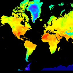
var dataset = ee.ImageCollection('ECMWF/ERA5_LAND/HOURLY')
                .filter(ee.Filter.date('2020-07-01', '2020-07-02'));

var visualization = {
  bands: ['temperature_2m'],
  min: 250.0,
  max: 320.0,
  palette: [
    '000080', '0000d9', '4000ff', '8000ff', '0080ff', '00ffff',
    '00ff80', '80ff00', 'daff00', 'ffff00', 'fff500', 'ffda00',
    'ffb000', 'ffa400', 'ff4f00', 'ff2500', 'ff0a00', 'ff00ff',
  ]
};

Map.setCenter(22.2, 21.2, 0);

Map.addLayer(dataset, visualization, 'Air temperature [K] at 2m height');
import ee
import geemap.core as geemap
কোলাব (পাইথন)
dataset = ee.ImageCollection('ECMWF/ERA5_LAND/HOURLY').filter(
    ee.Filter.date('2020-07-01', '2020-07-02')
)

visualization = {
    'bands': ['temperature_2m'],
    'min': 250.0,
    'max': 320.0,
    'palette': [
        '000080', '0000d9', '4000ff', '8000ff', '0080ff', '00ffff',
        '00ff80', '80ff00', 'daff00', 'ffff00', 'fff500', 'ffda00',
        'ffb000', 'ffa400', 'ff4f00', 'ff2500', 'ff0a00', 'ff00ff',
    ],
}

m = geemap.Map()
m.set_center(22.2, 21.2, 0)
m.add_layer(dataset, visualization, 'Air temperature [K] at 2m height')
m