
Page Summary
-
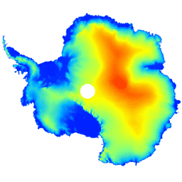
This dataset provides a digital elevation model (DEM) of the Antarctic ice sheet and ice shelves.
-
The DEM is based on observations from the CryoSat-2 satellite between July 2010 and July 2016.
-
The DEM is formed from fits to elevation measurements within 1, 2, and 5 km grid cells and is posted at a 1 km resolution.
-
The dataset includes bands for elevation, data composition method, slope, smoothed elevation, and elevation uncertainty.
-
The average accuracy of the DEM is estimated to be 9.5 meters.
- Dataset Availability
- 2010-07-01T00:00:00Z–2016-07-01T00:00:00Z
- Dataset Producer
- CPOM
- Tags
Description
This dataset is a digital elevation model (DEM) of the Antarctic ice sheet and ice shelves based on observations recorded by the CryoSat-2 satellite radar altimeter between July 2010 and July 2016.
The DEM is formed from spatio-temporal fits to elevation measurements accumulated within 1, 2, and 5 km grid cells, and is posted at the modal resolution of 1 km. The median and root mean square difference between the DEM and 2.3*107; airborne laser altimeter measurements acquired during NASA Operation IceBridge campaigns are -0.30 and 13.50 m, respectively.
The DEM uncertainty rises in regions of high slope, especially where elevation measurements were acquired in low-resolution mode; taking this into account, we estimate the average accuracy to be 9.5 m.
Bands
Bands
Pixel size: 1000 meters (all bands)
| Name | Units | Pixel Size | Description |
|---|---|---|---|
elevation |
m | 1000 meters | Antarctic ice sheet and ice shelf elevation. |
data_composition |
1000 meters | Data processing method of elevation per grid cell. |
|
slope |
deg | 1000 meters | Slope derived from elevation gradient. |
z_smoothed |
m | 1000 meters | Smoothed version of elevation model using a median filter. |
z_uncertainty |
m | 1000 meters | Certainty of elevation model derived from RMS of elevation residuals in observed grid cells and the kriging variance error in interpolated grid cells. |
data_composition Class Table
| Value | Color | Description |
|---|---|---|
| 0 | #000000 | interpolated |
| 1 | #cbcbcb | 1 km fit |
| 2 | #377eb7 | resampled 2 km fit |
| 3 | #e2191b | resampled 5 km fit |
Terms of Use
Terms of Use
The data are freely available. When using these data, please cite the provided article.
Citations
Slater, T., Shepherd, A., McMillan, M., Muir, A., Gilbert, L., Hogg, A. E., Konrad, H. and Parrinello, T.: A new Digital Elevation Model of Antarctica derived from CryoSat-2 altimetry, The Cryosphere, doi:10.5194/tc-2017-223, 2018
DOIs
Explore with Earth Engine
Code Editor (JavaScript)
var dataset = ee.Image('CPOM/CryoSat2/ANTARCTICA_DEM');

var visualization = {
  bands: ['elevation'],
  min: 0.0,
  max: 4000.0,
  palette: ['001fff', '00ffff', 'fbff00', 'ff0000']
};

Map.setCenter(17.0, -76.0, 3);

Map.addLayer(dataset, visualization, 'Elevation');