- Dataset Availability
- 2010-12-01T00:00:00Z–2020-11-13T00:00:00Z
- Dataset Producer
- Copernicus
- Tags
Description
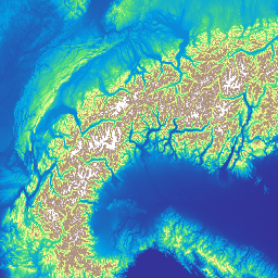
The Copernicus DEM is a Digital Surface Model (DSM) which represents the surface of the Earth including buildings, infrastructure and vegetation. This DEM is derived from an edited DSM named WorldDEM™, i.e., flattening of water bodies and consistent flow of rivers has been included. Editing of shore- and coastlines, special features such as airports and implausible terrain structures has also been applied.
The WorldDEM product is based on the radar satellite data acquired during the TanDEM-X Mission, which is funded by a Public Private Partnership between the German State, represented by the German Aerospace Centre (DLR) and Airbus Defence and Space. More details are available in the dataset documentation.
The DSM uses the EGM2008 vertical datum: EPSG:3855. This means a 0 elevation at a location does not imply the location is at a mean sea level.
Earth Engine asset has been ingested from the DGED files.
Bands
Bands
Pixel size: 30 meters (all bands)
| Name | Min | Max | Pixel Size | Description |
|---|---|---|---|---|
DEM |
30 meters | Digital Surface Model |
||
EDM |
0 | 13 | 30 meters | The Edit Data Mask indicates all DEM pixels that were modified during the terrain and hydro editing process. |
FLM |
0 | 101 | 30 meters | The Filling Mask is created primarily during the terrain editing process. |
HEM |
30 meters | The Height Error Mask represents the corresponding height error for each DEM pixel in the form of the standard deviation derived from the interferometric coherence and geometrical considerations. |
||
WBM |
0 | 3 | 30 meters | The Water Body Mask shows all DEM pixels which are classified as water and edited according to the categories Ocean, Lake or River. |
EDM Class Table
| Value | Color | Description |
|---|---|---|
| 0 | None | Void (no data) |
| 1 | None | Not edited |
| 2 | None | Infill of external elevation data |
| 3 | None | Interpolated pixels |
| 4 | None | Smoothed pixels |
| 5 | None | Airport editing |
| 6 | None | Raised negative elevation pixels |
| 7 | None | Flattened pixels |
| 8 | None | Ocean pixels |
| 9 | None | Lake pixels |
| 10 | None | River pixels |
| 11 | None | Shoreline pixels |
| 12 | None | Morphed pixels (series of pixels manually set) |
| 13 | None | Shifted pixels |
FLM Class Table
| Value | Color | Description |
|---|---|---|
| 0 | None | Void (no data) |
| 1 | None | Edited (except filled pixels) |
| 2 | None | Not edited / not filled |
| 3 | None | ASTER |
| 4 | None | SRTM90 |
| 5 | None | SRTM30 |
| 6 | None | GMTED2010 |
| 7 | None | SRTM30plus |
| 8 | None | TerraSAR-X Radargrammetric DEM |
| 9 | None | AW3D30 |
| 100 | None | Norway DEM |
| 101 | None | DSM05 Spain |
WBM Class Table
| Value | Color | Description |
|---|---|---|
| 0 | None | No water |
| 1 | None | Ocean |
| 2 | None | Lake |
| 3 | None | River |
Image Properties
Image Properties
| Name | Type | Description |
|---|---|---|
| tile_version | STRING | The release version of the Copernicus DEM tile (e.g., 02). |
Terms of Use
Terms of Use
The GLO-30 dataset is available worldwide with a free license. See the terms under 'Licence for the use of the Copernicus WorldDEM-30'.
When communicating to the General Public or distributing the Copernicus WorldDEM-30, the User shall inform the General Public of the source by using the following notice: © DLR e.V. 2010-2014 and © Airbus Defence and Space GmbH 2014-2018 provided under COPERNICUS by the European Union and ESA; all rights reserved.
Where the Copernicus WorldDEM-30 data have been adapted or modified, the User shall provide the following notice: "produced using Copernicus WorldDEM-30 © DLR e.V. 2010-2014 and © Airbus Defence and Space GmbH 2014-2018 provided under COPERNICUS by the European Union and ESA; all rights reserved”.
The following sentence or its translation in any language shall be added by such Users in a licence or any legal warning or notice covering their distribution or communication to the General Public of the Copernicus WorldDEM30: "The organisations in charge of the Copernicus programme by law or by delegation do not incur any liability for any use of the Copernicus WorldDEM-30".
Explore with Earth Engine
Code Editor (JavaScript)
var collection = ee.ImageCollection('COPERNICUS/DEM/GLO30_2024_1');
var nativeProj = collection.first().projection();
// Mosaic collection and set default projection from a sample image
// to ensure terrain analysis is done in the native scale and CRS.
var dataset = collection.mosaic().setDefaultProjection(nativeProj);

Map.setCenter(-6.746, 46.529, 4);

// Relative, vertical accuracy in form of the standard deviation of
// the interferometric phase error.
var hem = dataset.select('HEM');
var hemVis = {
  // Range of the values is 0.09 to 43.4.
  min: 0.0,
  max: 4.0,
  palette: ['blue', 'green', 'yellow', 'orange', 'darkorange', 'red'],
};
Map.addLayer(hem, hemVis, 'Height Error Mask (HEM; m)', false);

var edm = dataset.select('EDM');
var edmVis = {
  min: 0,
  max: 13,
  palette: [
    'black',      // 0: Void (no data)
    'white',      // 1: Not edited
    'red',        // 2: Infill of external elevation data
    'green',      // 3: Interpolated pixels
    'orange',     // 4: Smoothed pixels
    'yellow',     // 5: Airport editing
    'magenta',    // 6: Raised negative elevation pixels
    'cyan',       // 7: Flattened pixels
    'blue',       // 8: Ocean pixels
    'purple',     // 9: Lake pixels
    'brown',      // 10: River pixels
    'lightgray',  // 11: Shoreline pixels
    'olive',      // 12: Morphed pixels
    'steelblue',  // 13: Shifted pixels
  ],
};
Map.addLayer(edm, edmVis, 'Editing and Masking (EDM)', false, 0.75);

// Source data diagram.
var flm = dataset.select('FLM');
var originalValues = [0, 1, 2, 3, 4, 5, 6, 7, 8, 9, 100, 101];
var remappedValues = [0, 1, 2, 3, 4, 5, 6, 7, 8, 9, 10, 11];
var flmRemapped = flm.remap(originalValues, remappedValues).rename('FLM');
var flmVis = {
  min: 0,
  max: 11,
  palette: [
    'black',    // 0: Void (no data)
    'white',    // 1: Edited (except filled pixels)
    'grey',     // 2: Not edited / not filled
    'red',      // 3: ASTER
    'green',    // 4: SRTM90
    'blue',     // 5: SRTM30
    'yellow',   // 6: GMTED2010
    'cyan',     // 7: SRTM30plus
    'magenta',  // 8: TerraSAR-X Radargrammetric DEM
    'orange',   // 9: AW3D30
    'purple',   // 100 -> remapped to 10: Norway DEM
    'brown',    // 101 -> remapped to 11: DSM05 Spain
  ],
};
Map.addLayer(flmRemapped, flmVis, 'Fill and Lineage Mask (FLM)', false, 0.75);

var wbm = dataset.select('WBM');
var wbmVis = {
  min: 0,
  max: 3,
  palette: [
    'lightgray',   // 0: No water.
    'cadetblue',   // 1: Ocean.
    'darkblue',    // 2: Lake.
    'blueviolet',  // 3: River.
  ],
};
Map.addLayer(wbm, wbmVis, 'Water Body Mask (WBM)', false, 0.75);

var dsm = dataset.select('DEM').rename('DSM');
var dsmVis = {
  min: 0.0,
  max: 3000.0,
  palette:
      ['333399', '00a2e5', '55dd77', 'ffff99', 'aa926b', 'aa928d', 'ffffff'],
};
// Vertical datum: orthometric height (H) in meters above EGM2008.
// https://spatialreference.org/ref/epsg/3855/
var dsmName = 'Digital Surface Model (DSM; m above EGM08)';
Map.addLayer(dsm, dsmVis, dsmName, true, 0.75);

// Multiply by 20 to exaggerate the hillshade for a better visualization.
Map.addLayer(
    ee.Terrain.hillshade(dsm.multiply(20.0)), null,
    'Digital Surface Model (DSM) Hillshade', true, 0.75);