- 利用可能なデータセットの期間
- 2000-01-01T00:00:00Z–2020-01-01T00:00:00Z
- データセット プロデューサー
- 国際地球科学情報ネットワーク センターの NASA SEDAC
- ケイデンス
- 5 年
- タグ
説明
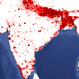
このデータセットには、国勢調査と人口登録と一致する 1 平方キロメートルあたりの人口の推定値が含まれています。モデル化された年ごとに 1 つの画像があります。
Gridded Population of World Version 4(GPWv4)、Revision 11 は、2000 年、2005 年、2010 年、2015 年、2020 年の世界の人口分布を 30 秒(約 1 km)のグリッド セルでモデル化しています。人口は、国勢調査と行政単位の人口の比例配分を使用してセルに分布します。人口入力データは、2005 年から 2014 年の間に実施された 2010 年の国勢調査の結果から得られる最も詳細な空間解像度で収集されます。入力データが外挿され、モデル化された各年の人口推定値が生成されます。
バンド
バンド
ピクセルサイズ: 927.67 メートル(すべてのバンド)
| 名前 | 最小 | 最大 | ピクセルサイズ | 説明 |
|---|---|---|---|---|
population_density |
0* | 810,694* | 927.67 メートル | 1 平方キロメートルあたりの推定人数。 |
利用規約
利用規約
引用
引用:
コロンビア大学国際地球科学情報ネットワーク センター(CIESIN)。2018 年。Gridded Population of the World, Version 4(GPWv4): Population Density, Revision 11。Palisades, NY: NASA Socioeconomic Data and Applications Center(SEDAC)。https://doi.org/10.7927/H49C6VHW。アクセスした日、月、年。
DOI
Earth Engine で探索する
コードエディタ(JavaScript)
var dataset = ee.ImageCollection('CIESIN/GPWv411/GPW_Population_Density').first();
var raster = dataset.select('population_density');
var raster_vis = {
  'max': 1000.0,
  'palette': [
    'ffffe7',
    'FFc869',
    'ffac1d',
    'e17735',
    'f2552c',
    '9f0c21'
  ],
  'min': 200.0
};
Map.setCenter(79.1, 19.81, 3);
Map.addLayer(raster, raster_vis, 'population_density');