- Catalog Owner
- Continuous Global Mangrove Dynamics
- Dataset Availability
- 1984-01-01T00:00:00Z–2023-12-31T23:59:59Z
- Dataset Producer
- The Mangrove Lab
- Cadence
- 1 Year
- Tags
Description
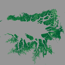
This dataset provides global annual mangrove fractional canopy cover (FCC) at 30-m spatial resolution from 1984 to 2023 to support large-scale analyses of long-term mangrove dynamics, including canopy degradation and recovery, blue carbon assessment, and coastal ecosystem monitoring. FCC quantifies the proportion of each Landsat pixel occupied by mangrove canopy and is expressed as a percentage ranging from 0% to 100%.
The dataset was generated using time-series Landsat imagery within the Google Earth Engine platform. Annual Landsat composites were produced after strict cloud, cloud-shadow, and low-quality observation filtering. FCC was then estimated using a linear spectral unmixing approach and spatially constrained to the global mangrove extent for each year.
The FCC estimates were evaluated against high-resolution Planet imagery across different regions, with root mean square error (RMSE) ranging from 9% to 22%.
Users should note that FCC values are derived from annual median Landsat composites. As a result, canopy changes occurring late in a calendar year may be captured in the following year's composite, which can introduce a one-year lag in the timing of detected FCC change. For quick visualization and exploratory analysis, users are encouraged to access the CGMD Earth Engine App.
Bands
Bands
Pixel size: 30 meters (all bands)
| Name | Units | Min | Max | Pixel Size | Description |
|---|---|---|---|---|---|
FCC |
% | 0* | 100* | 30 meters | Mangrove fractional canopy cover stored as integer percentage cover from 0 to 100 |
Image Properties
Image Properties
| Name | Type | Description |
|---|---|---|
| year | INT | Data year, ranging from 1984 to 2023. |
| tile_id | STRING | Data region |
| version | STRING | Data version |
Terms of Use
Terms of Use
Acknowledgements
Users should cite the associated scientific paper and the Zenodo data record when using this dataset in publications or derived products.
License
The dataset is licensed under the CC-BY 4.0 license.
Citations
Zhang, Z., Murray, N., Song, X., ... & Friess, D. (2026) Continuous Global Mangrove Dynamics: Annual mangrove fractional canopy cover, 1984-2023 [Data set]. Zenodo. https://doi.org/10.5281/zenodo.18496588
Zhang, Z., Murray, N., Song, X., ... & Friess, D. (2026) Unexpected expansion and regrowth in Earth's mangrove forests over the past four decades. Science. https://doi.org/10.1126/science.aec9773
DOIs
Explore with Earth Engine
Code Editor (JavaScript)
// Define the data variable for CGMD-AFCC30
var dataset = ee.ImageCollection('projects/mangrovedatahub2/assets/CGMD-AFCC30');

// Define the year for visualization
var year = 2023;

// Load the fractional canopy cover image for the year 2023
var fcc = dataset
  .filter(ee.Filter.eq('year', year))
  .mosaic();

// Define visualization parameters
var vis = {
  min: 0,
  max: 100,
  palette: ['ffffff', 'd9f0a3', '78c679', '238443', '005a32']
};

// Center the map on the image with a zoom level of 8 (covers Bintuni Bay, Indonesia)
Map.setCenter(133.3826, -2.3649, 8);

// Add the layer to the map
Map.addLayer(fcc, vis, 'Mangrove fractional canopy cover, ' + year);