Google Public Alerts is Google’s platform for disseminating emergency messages. Common examples of alerts include weather-related warnings such as tropical storms, floods, and tornadoes, as well as earthquakes and other public safety event information. We aim to show relevant official weather, public safety and earthquake alerts around the world on the Public Alerts homepage, www.google.org/publicalerts, when you search on Google Search and Google Maps, and when you activate Google Now on your Android device.
Google Public Alerts makes critical information more accessible during natural disasters. It gets emergency information to the public at scale and visualizes information in a way that makes it actionable. Send your alerts content to Google to help ensure that people who are impacted get information about what’s going on.
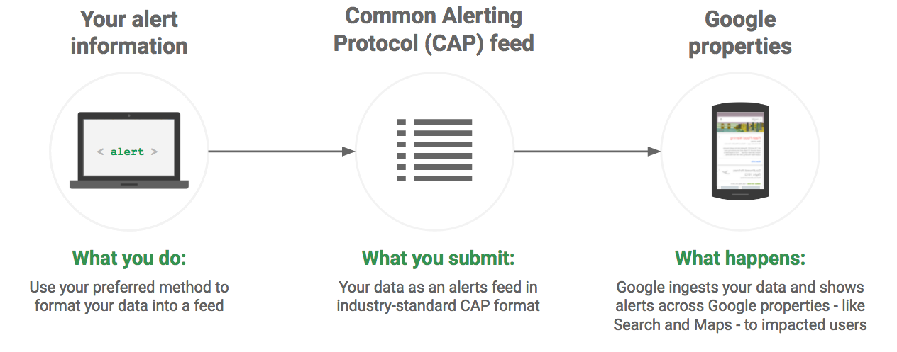
About this site
The site highlights the data that Google needs from you in order to display Google Public Alerts, the steps required for you to prepare that data and share it with Google, and the overall integration process. Data is in the Common Alerting Protocol (CAP) format, which is a non-proprietary, industry standard specification designed for transmitting alerts. The format defines how to specify details of the alert, such as the targeted geographic area, effective time, and expiration time, and how to update or cancel alerts.
Who can publish Google Public Alerts
Partners who publish a Google Public Alert must be:
- a public safety agency or a public alerts provider with information that affects people’s life and property, and
- the original and authoritative author of the alert information OR have rights from the original author to aggregate and/or distribute this information.
All meteorological agencies should register with the WMO register of alerting authorities. In the U.S., we also prefer for our partners to be a certified IPAWS Public Alerting Authority.
Google Public Alerts integrations
Alerts data originate from our partners, and are integrated into Google Search, Maps, and Now cards. Alerts include a description of the event, the geographical area and timing of the event, and any possible actions that should be taken by those who are affected by the event.
Google Search
Desktop and mobile searches trigger alerts when and where they are relevant for our users. The alerts information that you provide defines the area affected by an emergency or warning condition, and the severity of the event. Along with this information, factors that determine who will see the alert include the user's query and the location of the user's device. For example, a user who is outside the affected area described in the CAP data may need to enter a more detailed search query to see the alert than a user who is inside the affected area.
The alert results in a warning that the user can click through to find out more information.
Google Maps
Google Maps displays geographic data to users on computers, tablets, and mobile phones.
When searching an area in Maps on a desktop or a mobile app, nearby relevant alerts for that area appear. The mobile app also provides location based warning notifications for relevant alerts.
Google Now
Google Now provides active relevant alert notifications based on the device location. Notifications include a description of what’s going on, the affected area, and possible actions to take in order to stay safe.
How Google Public Alerts work
- Partners format their data in the industry standard Common Alerting Protocol (CAP) format.
- Partners transmit the CAP formatted data in a feed.
- Google ingests the data and publishes it. Note that since the data format is an industry standard, it can be provided to any downstream consumer that supports the Common Alerting Protocol.