Google Earth lets you bring in your own geospatial data to view, analyze, and
share. You can import data in several ways, depending on the file type, size,
and how you want to use it:
- **As map features:** Suitable for simple KML/KMZ files containing up to 10,000 features or 250,000 vertices. Features are added directly to your Google Earth project in Google Drive and are editable. Files that are too large will be automatically loaded as data layers.
- **As data layers:** Ideal for large datasets (KML, GeoJSON, shapefile). Data layers are optimized for performance and are embedded within your Google Earth project, stored in Google Drive. They can be styled but not edited. Data layers use up Google Earth storage quota.
- **As local KML files:** Open KML/KMZ files stored on your device. These are not part of a Drive-based project and are only visible on the device where they were opened.
For more information about the differences between layers, map features, and
local files, see [Learn about Google Earth projects and local KML
files](https://developers.google.com/maps/documentation/earth/projects-kml).
If you are migrating data from Google Earth Pro on desktop to Google Earth on
web, see [Migrate data from Google Earth Pro on Desktop to Google Earth
Web](https://developers.google.com/maps/documentation/earth/import-kml#migrate_data_from_google_earth_pro_on_desktop_to_google_earth_web).
### Computer
## Import as a data layer
This method is best for visualizing large datasets.
Supported file formats:
- KML, KMZ
- GeoJSON
- Shapefile (ZIP file)
- CSV (`.csv`) **(Experimental)**
- Google Sheets (from Google Drive) **(Experimental)**
> [!NOTE]
> **Note:** If you try to import a large KML/KMZ file as [map
> features](https://developers.google.com/maps/documentation/earth/import-data#import_features_into_a_google_earth_project), Google Earth automatically uploads the file as a data layer as a fallback.
To import a file as a data layer:
1. On your computer, open [Google Earth](https://earth.google.com/) and ensure you are signed in.
2. You can start an import in several ways:
- From the home screen: Click **New** **Import file**.
- From the menu in a project: Click **File** **Import**....
3. Choose your file from your device or Google Drive.
4. In the import dialog, select **Import as a data layer** . This option may be pre-selected or the only option if your file is large or not suitable for map features.
- For all file types except KML, this option is pre-selected.
- Tabular datasets are ingested as Google Earth data layers.
5. The file will be uploaded and processed. You can track the progress in the import widget. Large files may take some time.
Once complete, the layer will be added to your open project or a new project if
none was open.
> [!NOTE]
> **Note:** Copying imported data layers from one document to another will result in additional quota being charged. Imported data layers copied within the same document won't result in a charge.
Imported data layers are subject to storage quotas based on your Google Earth
plan. For more information, see [Manage imported data layers and
storage](https://developers.google.com/maps/documentation/earth/manage-layers-storage).
### Import CSV and Google Sheets files (Experimental)
The following table describes supported formatting for CSV and Google Sheet
files.
> [!NOTE]
> **Note:** When you import a CSV file, Google Earth checks the headers and data to detect the location format for mapping. Column headers in the following languages are automatically recognized: Arabic, English, French, German, Indonesian, Italian, Japanese, Portuguese, Russian, Spanish.
| Formatting type | Description | Example |
|---|---|---|
| Latitude and longitude (separate columns) | Two separate columns containing numeric coordinate values in signed decimal degrees within WGS84 bounds (latitude -90.0 to 90.0, longitude -180.0 to 180.0). Coordinates must not include degree symbols (`°`) or cardinal direction letters (`N`, `S`, `E`, `W`). Negative values represent South latitude and West longitude. | name,latitude,longitude,category,elevation_m Site A,37.4220,-122.0841,Research,12.5 Site B,37.4245,-122.0882,Park,14.0 |
| Well-Known Text (WKT) | Columns containing standard WKT geometries (for example, `POINT`, `POLYGON`, `LINESTRING`). Coordinates must be in WGS84 decimal degrees (longitude -180.0 to 180.0, latitude -90.0 to 90.0) using standard **Longitude Latitude** order (for example, `POINT(-122.084 37.422)`). WKT keywords and headers are case-insensitive. | name,geometry,status Area 1,"POLYGON((-122.085 37.421, -122.083 37.421, -122.083 37.423, -122.085 37.423, -122.085 37.421))",Active Marker 2,"POINT(-122.084 37.422)",Pending |
| Address column | Columns containing full street addresses. Google Earth recognizes single-column street addresses and geocodes them globally. | name,street_address,city,state,postal_code Headquarters,1600 Amphitheatre Pkwy,Mountain View,CA,94043 Tokyo Office,Roppongi Hills Mori Tower,Minato City,Tokyo,106-6126 |
> [!NOTE]
> **Note:** Single-column coordinates (for example, `"37.422, -122.084"` in a single cell) are not auto-detected. If your dataset contains bundled coordinates, split them into separate Latitude and Longitude columns before importing. Files must be saved in UTF-8 encoding with standard comma separation.
Additional non-spatial columns (such as names, dates, descriptions, categories,
or numeric metrics) are automatically preserved as feature attributes and
displayed in data tables and property inspect cards.
#### Error handling and reporting import issues
If an individual row contains invalid coordinates or cannot be resolved by
the geocoder, Google Earth still imports all other valid rows. If no
geometry can be auto-detected in the file, an error guide dialog appears
with guidance on checking your column formats.
If your file fails to import or completes with unsupported elements, click
the underlined **Failed** or **Completed** status link in the import status
tracker in the left-hand panel to open the **Fixing issues with imported
files** dialog.
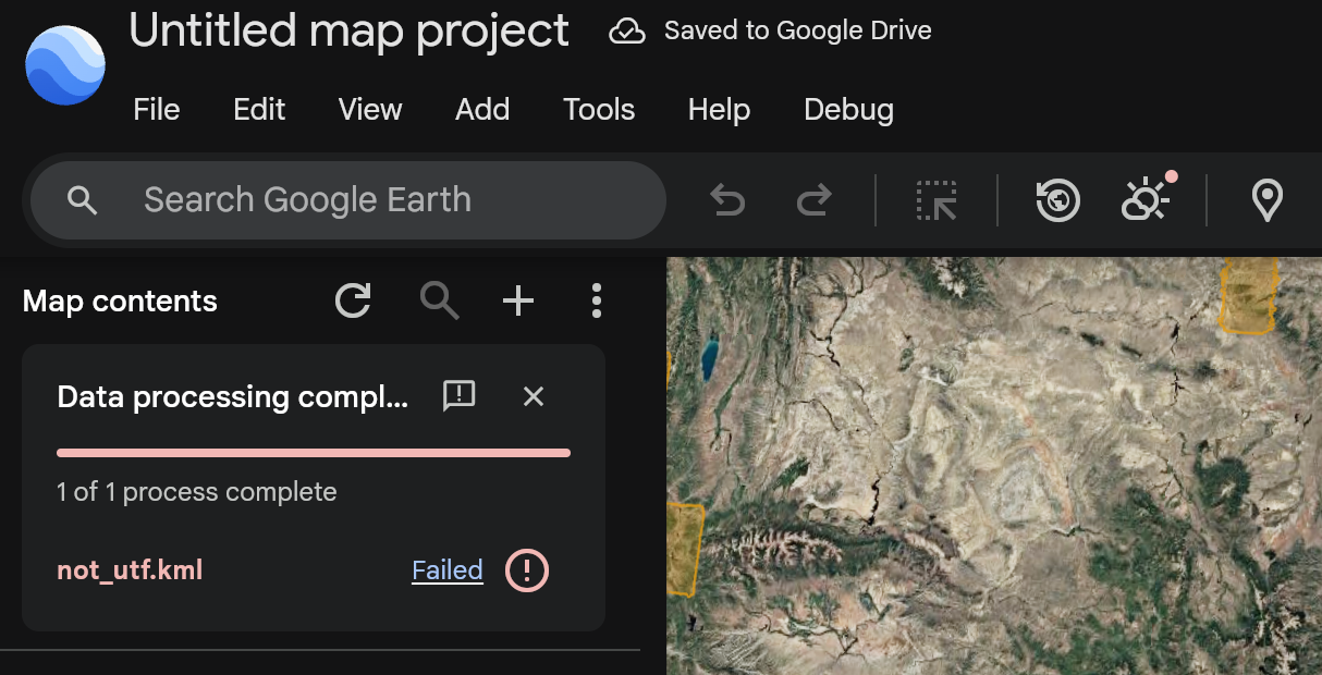 To report
a file import problem to the Google Earth team:
- **From the error guide dialog:** Click **Report import issue** at the bottom of the **Fixing issues with imported files** dialog to open the Google issue tracker in a new tab with your platform, Google Earth version, and diagnostic error codes automatically filled in. You may be required to sign in again with your Google Account.
- **From the import status tracker:** Click the feedback **Report import
issue** icon in the header of the import status tracker while an import is running or after it finishes (including when a file imports with zero errors but does not appear as expected on the map).
If you've opted in to receiving notifications, you will receive updates if
the report has any actions taken by the team.
## Import features into a Google Earth project
This method is suitable for KML or KMZ files with up to 10,000 features.
To import the file into an existing project:
1. On your computer, open [Google Earth](https://earth.google.com/) and ensure you are signed in.
2. In the home screen, click an existing project.
3. At the top left, click **File Import file** .
- To add a file from Google Drive, click **Import from Drive**.
- To add a file directly from your computer, click **Upload from device**.
4. Select the file you want to import.
5. If prompted to choose an output type, select **Import as project features**.
After you select the file you want to import, it will automatically be added to
an existing Google Earth project.
> [!NOTE]
> **Note:** If your KML/KMZ file is too large to import as map features, Google Earth will automatically retry importing the file as a read-only [data
> layer](https://developers.google.com/maps/documentation/earth/import-data#import_as_a_data_layer) instead. When this fallback occurs, a notification appears on your screen.
To go to the home screen, click Earth
.
## Import a file into a new project
You can import a KML or KMZ file (with up to 10,000 features) from an older
version of Google Earth to a new project.
> [!NOTE]
> **Note:** You can only import a file into a new project if you're signed in.
To import the file into a new Google Earth project:
1. On your computer, open [Google Earth](https://earth.google.com/).
2. At the top left, click **New Import file to map project** .
- To add a file from Google Drive, click **Import from Drive**.
- To add a file directly from your computer, click **Upload from device**.
3. Select the file you want to import.
After you select the file you want to import, it will automatically create a new
project saved in Google Drive.
To go to the home screen, click Earth
.
## Import a My Maps file into a new project
You can open a map created in Google My Maps directly from Google Drive and view
it within the Google Earth interface.
> [!NOTE]
> **Note:** You must be signed in to your Google Account to access and import files stored in Google Drive.
To open and convert a My Maps file:
1. On your computer, open [Google Earth](https://earth.google.com/).
2. Click **New \> Open My Maps from Drive**.
3. Locate your My Maps file in the Google Drive window, select it, and click **Insert** .
- The My Maps file will now appear in Google Earth in view-only mode.
4. To make the data editable, click **Save as map project** in the top toolbar (available on web only).
5. You will be prompted to optionally rename the project title and update your sharing permissions. Once finalized, click **OK**.
Your map is now saved as a new, editable Google Earth map project. The original
My Maps file remains untouched in your Google Drive.
## Open local KML files in Google Earth
[Video](https://www.youtube.com/watch?v=8dyIWSasKn8)
You can open a KML or KMZ file (without feature limits) from an older
version of Google Earth as a local KML file.
To open local KML files in Google Earth:
1. On your computer, open [Google Earth](https://earth.google.com/).
2. At the bottom left on the home screen, click **Open local KML editor**.
3. Click **Open KML from device**.
4. Select the KML file you want to open.
After you select the file you want to open, any changes must be explicitly saved
or downloaded back to your computer's file system to avoid losing work. Autosave
is supported only on Chromium-based desktop browsers.
> [!NOTE]
> **Note:** You can open local KML files in Google Earth even if you're not signed in.
To go to the home screen, click Earth
.
## Import other file formats
Google Earth for web and mobile primarily supports KML, KMZ, GeoJSON, and
Shapefile (`.zip`) for direct import.
For [CSV and Google Sheets files](https://developers.google.com/maps/documentation/earth/import-data.md.txt#import-csv-and-google-sheets-files),
Google Earth supports direct import as a data layer with automatic location
detection. For other vector or raster formats (for example, GPX), you can
convert these files to KML or CSV. Once converted to KML, you can import them
into Google Earth.
[Learn how to use KML
features](https://developers.google.com/kml/documentation/).
## Migrate data from Google Earth Pro on Desktop to Google Earth Web
[Video](https://www.youtube.com/watch?v=JymH5eLf-pU)
If you are moving from Google Earth Pro (Desktop) to the web version, you can
bring your "My Places" data with you.
### Prepare your data for migration
Before importing, you must export your data from Google Earth Pro:
1. Open **Google Earth Pro** on your computer.
2. In the "Places" panel on the left, right-click on **My Places** or a specific folder.
3. Select **Save Place As...**.
4. Save the file as a `.kmz` or `.kml` to your computer.
If you cannot open Google Earth Pro or need to find the raw source files
(typically named `myplaces.kml`), they are stored in the following directories.
> [!NOTE]
> **Note:** These folders are often hidden by default.
#### Windows
Copy and paste the following path into your File Explorer address bar:
`%USERPROFILE%\AppData\Local\Google\GoogleEarth`.
> [!TIP]
> **Tip:** If you are navigating manually, you may need to enable "Hidden items" under the View tab in File Explorer to see the `AppData` folder.
#### macOS
Open Finder, press **Command** + **Shift** + **G** , and paste this path:
`~/Library/Application Support/Google Earth`.
What to look for:
- `myplaces.kml`: This is your current, live data.
- `myplaces.backup.kml`: A backup created the last time you launched the app.
- `myplaces.kml.tmp`: A temporary file created during a session.
### Import capabilities and limitations
When migrating "My Places," your choice of import method depends on the
complexity of your data. For a detailed breakdown of supported KML elements,
refer to the [Google Earth KML Import
Guide](https://support.google.com/earth/community-guide/307322063/google-earth-kml-import-guide).
- **Feature Counts**: If you intend to import your data as project features (allowing you to edit icons, lines, and shapes), there is a limit of approximately 10,000 features or 250,000 vertices per project. If an import exceeds these limits, Google Earth will automatically attempt to import your data as a read-only data layer instead.
- **Large "My Places" Files** : For Google Earth Pro on desktop users that have "My Places" files that exceed 10,000 features or contain several megabytes of data we recommend you:
- **Split your data** : Divide your "My Places" into smaller, thematic folders in Earth Pro and save each as a separate `.kmz` file.
- **Import as Data Layers** : If you have tens of thousands of points and don't need to edit them individually, use the **Import as a data layer** option.
- **Copy and Paste** : You can also copy individual features or folders from Google Earth Pro and paste them directly into a Google Earth project. Simply select the feature in the desktop version, right-click to Copy (**Ctrl** + **C** or **Cmd** + **C** ), go to your Google Earth browser tab, and Paste (**Ctrl** + **V** or **Cmd** + **V**) while a project is open.
## Other viewing options
For temporary, local-only access, you can also open your KML files directly in
Google Earth on web through the local KML editor experience.
> [!NOTE]
> **Note:** This mode does not support cloud storage or advanced project features.
To see data from multiple projects on the map at once, you can use the
[reference projects](https://medium.com/google-earth/enhancing-project-management-in-google-earth-a-guide-to-the-latest-updates-ad096c34d239)
feature.
### Android
## Import a file into an existing Earth project
You can import a basic KML or KMZ file from an older version of Google Earth to
an existing Earth project. To import the file into an existing Google Earth
project:
1. On your Android phone or tablet, open the Google Earth app .
2. In the home screen, tap an existing project.
3. At the bottom, tap **More Import KML / KMZ to project** .
- To add a file from Google Drive, tap **Import from Drive**.
- To add a file directly from your device, tap **Upload from device**.
4. Select the file you want to import.
5. To return to the map and open the file, tap **Back**.
After you select the file you want to import, it will automatically be added to
the existing project.
## Import a file into a new project
You can import a simple KML or KMZ file from an older version of Google Earth to
an existing project. To import the file into an existing
project:
1. On your Android phone or tablet, open the Google Earth app .
2. At the bottom, tap **New** .
- To add a file from Google Drive, tap **Import file to project from Drive**.
- To add a file directly from your device, tap **Import file to project from device**.
3. Select the file you want to import.
4. To return to the map and open the file, tap **Back**.
After you select the file you want to import, it will automatically be added to
the existing Earth project.
## Open local KML files in Google Earth
You can open a basic KML or KMZ file from an older version of Google Earth as a
local KML file. To open local KML files in Google Earth:
1. On your Android phone or tablet, open the Google Earth app .
2. Select the **Local** tab on the home screen.
3. At the bottom right, tap **New Local KML editor**.
4. Select **Open KML/Z from device**.
5. To return to the map and open the file, tap **Back**.
After you select the file you want to open, it will automatically be stored in
your local KML files tab on the home screen.
### iOS
## Import a file into an existing Earth project
You can import a basic KML or KMZ file from an older version of Google Earth to
an existing Earth project. To import the file into an existing Google Earth
project:
1. On your iPhone or iPad, open the Google Earth app .
2. In the home screen, tap an existing project.
3. At the bottom, tap **More Import KML / KMZ to project** .
- To add a file from Google Drive, tap **Import from Drive**.
- To add a file directly from your device, tap **Upload from device**.
4. Select the file you want to import.
5. To return to the map and open the file, tap **Back**.
After you select the file you want to import, it will automatically be added to
the existing project.
## Import a file into a new project
You can import a simple KML or KMZ file from an older version of Google Earth to
an existing project. To import the file into an existing
project:
1. On your iPhone or iPad, open the Google Earth app .
2. At the bottom, tap **New** .
- To add a file from Google Drive, tap **Import file to project from Drive**.
- To add a file directly from your device, tap **Import file to project from device**.
3. Select the file you want to import.
4. To return to the map and open the file, tap **Back**.
After you select the file you want to import, it will automatically be added to
the existing Earth project.
## Open local KML files in Google Earth
You can open a basic KML or KMZ file from an older version of Google Earth as a
local KML file. To open local KML files in Google Earth:
1. On your iPhone or iPad, open the Google Earth app .
2. Select the **Local** tab on the home screen.
3. At the bottom right, tap **New Local KML editor**.
4. Select **Open KML/Z from device**.
5. To return to the map and open the file, tap **Back**.
After you select the file you want to open, it will automatically be stored in
your local KML files tab on the home screen.