Hier wird beschrieben, wie Sie den aktuellen Standort eines Android-Geräts ermitteln und zu diesem Ort (einem Geschäft oder POI) Details anzeigen können. Folgen Sie dieser Anleitung, um mit dem Maps SDK for Android, dem Places SDK for Android und dem Anbieter für kombinierte Standortbestimmung in den Standort-APIs der Google Play-Dienste eine Android-App zu erstellen.
Code abrufen
So sieht die Java-Version der Aktivität aus:
    // Copyright 2020 Google LLC
//
// Licensed under the Apache License, Version 2.0 (the "License");
// you may not use this file except in compliance with the License.
// You may obtain a copy of the License at
//
//      http://www.apache.org/licenses/LICENSE-2.0
//
// Unless required by applicable law or agreed to in writing, software
// distributed under the License is distributed on an "AS IS" BASIS,
// WITHOUT WARRANTIES OR CONDITIONS OF ANY KIND, either express or implied.
// See the License for the specific language governing permissions and
// limitations under the License.

package com.example.currentplacedetailsonmap;

import android.content.DialogInterface;
import android.content.pm.PackageManager;
import android.location.Location;
import android.os.Bundle;

import android.util.Log;
import android.view.Menu;
import android.view.MenuItem;
import android.view.View;
import android.widget.FrameLayout;
import android.widget.TextView;

import androidx.annotation.NonNull;
import androidx.appcompat.app.AlertDialog;
import androidx.appcompat.app.AppCompatActivity;
import androidx.core.app.ActivityCompat;
import androidx.core.content.ContextCompat;

import com.google.android.gms.location.FusedLocationProviderClient;
import com.google.android.gms.location.LocationServices;
import com.google.android.gms.maps.CameraUpdateFactory;
import com.google.android.gms.maps.GoogleMap;
import com.google.android.gms.maps.OnMapReadyCallback;
import com.google.android.gms.maps.SupportMapFragment;
import com.google.android.gms.maps.model.CameraPosition;
import com.google.android.gms.maps.model.LatLng;
import com.google.android.gms.maps.model.Marker;
import com.google.android.gms.maps.model.MarkerOptions;
import com.google.android.gms.tasks.OnCompleteListener;
import com.google.android.gms.tasks.Task;

import com.google.android.libraries.places.api.Places;
import com.google.android.libraries.places.api.model.Place;
import com.google.android.libraries.places.api.model.PlaceLikelihood;
import com.google.android.libraries.places.api.net.FindCurrentPlaceRequest;
import com.google.android.libraries.places.api.net.FindCurrentPlaceResponse;
import com.google.android.libraries.places.api.net.PlacesClient;

import java.util.Arrays;
import java.util.List;

/**
 * An activity that displays a map showing the place at the device's current location.
 */
public class MapsActivityCurrentPlace extends AppCompatActivity
        implements OnMapReadyCallback {

    private static final String TAG = MapsActivityCurrentPlace.class.getSimpleName();
    private GoogleMap map;
    private CameraPosition cameraPosition;

    // The entry point to the Places API.
    private PlacesClient placesClient;

    // The entry point to the Fused Location Provider.
    private FusedLocationProviderClient fusedLocationProviderClient;

    // A default location (Sydney, Australia) and default zoom to use when location permission is
    // not granted.
    private final LatLng defaultLocation = new LatLng(-33.8523341, 151.2106085);
    private static final int DEFAULT_ZOOM = 15;
    private static final int PERMISSIONS_REQUEST_ACCESS_FINE_LOCATION = 1;
    private boolean locationPermissionGranted;

    // The geographical location where the device is currently located. That is, the last-known
    // location retrieved by the Fused Location Provider.
    private Location lastKnownLocation;

    // Keys for storing activity state.
    private static final String KEY_CAMERA_POSITION = "camera_position";
    private static final String KEY_LOCATION = "location";

    // Used for selecting the current place.
    private static final int M_MAX_ENTRIES = 5;
    private String[] likelyPlaceNames;
    private String[] likelyPlaceAddresses;
    private List[] likelyPlaceAttributions;
    private LatLng[] likelyPlaceLatLngs;

    @Override
    protected void onCreate(Bundle savedInstanceState) {
        super.onCreate(savedInstanceState);

        // Retrieve location and camera position from saved instance state.
        if (savedInstanceState != null) {
            lastKnownLocation = savedInstanceState.getParcelable(KEY_LOCATION);
            cameraPosition = savedInstanceState.getParcelable(KEY_CAMERA_POSITION);
        }

        // Retrieve the content view that renders the map.
        setContentView(R.layout.activity_maps);

        // Construct a PlacesClient
        Places.initialize(getApplicationContext(), BuildConfig.MAPS_API_KEY);
        placesClient = Places.createClient(this);

        // Construct a FusedLocationProviderClient.
        fusedLocationProviderClient = LocationServices.getFusedLocationProviderClient(this);

        // Build the map.
        SupportMapFragment mapFragment = (SupportMapFragment) getSupportFragmentManager()
                .findFragmentById(R.id.map);
        mapFragment.getMapAsync(this);
    }

    /**
     * Saves the state of the map when the activity is paused.
     */
    @Override
    protected void onSaveInstanceState(Bundle outState) {
        if (map != null) {
            outState.putParcelable(KEY_CAMERA_POSITION, map.getCameraPosition());
            outState.putParcelable(KEY_LOCATION, lastKnownLocation);
        }
        super.onSaveInstanceState(outState);
    }

    /**
     * Sets up the options menu.
     * @param menu The options menu.
     * @return Boolean.
     */
    @Override
    public boolean onCreateOptionsMenu(Menu menu) {
        getMenuInflater().inflate(R.menu.current_place_menu, menu);
        return true;
    }

    /**
     * Handles a click on the menu option to get a place.
     * @param item The menu item to handle.
     * @return Boolean.
     */
    @Override
    public boolean onOptionsItemSelected(MenuItem item) {
        if (item.getItemId() == R.id.option_get_place) {
            showCurrentPlace();
        }
        return true;
    }

    /**
     * Manipulates the map when it's available.
     * This callback is triggered when the map is ready to be used.
     */
    @Override
    public void onMapReady(GoogleMap map) {
        this.map = map;

        // Use a custom info window adapter to handle multiple lines of text in the
        // info window contents.
        this.map.setInfoWindowAdapter(new GoogleMap.InfoWindowAdapter() {

            @Override
            // Return null here, so that getInfoContents() is called next.
            public View getInfoWindow(Marker arg0) {
                return null;
            }

            @Override
            public View getInfoContents(Marker marker) {
                // Inflate the layouts for the info window, title and snippet.
                View infoWindow = getLayoutInflater().inflate(R.layout.custom_info_contents,
                        (FrameLayout) findViewById(R.id.map), false);

                TextView title = infoWindow.findViewById(R.id.title);
                title.setText(marker.getTitle());

                TextView snippet = infoWindow.findViewById(R.id.snippet);
                snippet.setText(marker.getSnippet());

                return infoWindow;
            }
        });

        // Prompt the user for permission.
        getLocationPermission();

        // Turn on the My Location layer and the related control on the map.
        updateLocationUI();

        // Get the current location of the device and set the position of the map.
        getDeviceLocation();
    }

    /**
     * Gets the current location of the device, and positions the map's camera.
     */
    private void getDeviceLocation() {
        /*
         * Get the best and most recent location of the device, which may be null in rare
         * cases when a location is not available.
         */
        try {
            if (locationPermissionGranted) {
                Task<Location> locationResult = fusedLocationProviderClient.getLastLocation();
                locationResult.addOnCompleteListener(this, new OnCompleteListener<Location>() {
                    @Override
                    public void onComplete(@NonNull Task<Location> task) {
                        if (task.isSuccessful()) {
                            // Set the map's camera position to the current location of the device.
                            lastKnownLocation = task.getResult();
                            if (lastKnownLocation != null) {
                                map.moveCamera(CameraUpdateFactory.newLatLngZoom(
                                        new LatLng(lastKnownLocation.getLatitude(),
                                                lastKnownLocation.getLongitude()), DEFAULT_ZOOM));
                            }
                        } else {
                            Log.d(TAG, "Current location is null. Using defaults.");
                            Log.e(TAG, "Exception: %s", task.getException());
                            map.moveCamera(CameraUpdateFactory
                                    .newLatLngZoom(defaultLocation, DEFAULT_ZOOM));
                            map.getUiSettings().setMyLocationButtonEnabled(false);
                        }
                    }
                });
            }
        } catch (SecurityException e)  {
            Log.e("Exception: %s", e.getMessage(), e);
        }
    }

    /**
     * Prompts the user for permission to use the device location.
     */
    private void getLocationPermission() {
        /*
         * Request location permission, so that we can get the location of the
         * device. The result of the permission request is handled by a callback,
         * onRequestPermissionsResult.
         */
        if (ContextCompat.checkSelfPermission(this.getApplicationContext(),
                android.Manifest.permission.ACCESS_FINE_LOCATION)
                == PackageManager.PERMISSION_GRANTED) {
            locationPermissionGranted = true;
        } else {
            ActivityCompat.requestPermissions(this,
                    new String[]{android.Manifest.permission.ACCESS_FINE_LOCATION},
                    PERMISSIONS_REQUEST_ACCESS_FINE_LOCATION);
        }
    }

    /**
     * Handles the result of the request for location permissions.
     */
    @Override
    public void onRequestPermissionsResult(int requestCode,
                                           @NonNull String[] permissions,
                                           @NonNull int[] grantResults) {
        locationPermissionGranted = false;
        if (requestCode
            == PERMISSIONS_REQUEST_ACCESS_FINE_LOCATION) {// If request is cancelled, the result arrays are empty.
            if (grantResults.length > 0
                && grantResults[0] == PackageManager.PERMISSION_GRANTED) {
                locationPermissionGranted = true;
            }
        } else {
            super.onRequestPermissionsResult(requestCode, permissions, grantResults);
        }
        updateLocationUI();
    }

    /**
     * Prompts the user to select the current place from a list of likely places, and shows the
     * current place on the map - provided the user has granted location permission.
     */
    private void showCurrentPlace() {
        if (map == null) {
            return;
        }

        if (locationPermissionGranted) {
            // Use fields to define the data types to return.
            List<Place.Field> placeFields = Arrays.asList(Place.Field.NAME, Place.Field.ADDRESS,
                    Place.Field.LAT_LNG);

            // Use the builder to create a FindCurrentPlaceRequest.
            FindCurrentPlaceRequest request =
                    FindCurrentPlaceRequest.newInstance(placeFields);

            // Get the likely places - that is, the businesses and other points of interest that
            // are the best match for the device's current location.
            @SuppressWarnings("MissingPermission") final
            Task<FindCurrentPlaceResponse> placeResult =
                    placesClient.findCurrentPlace(request);
            placeResult.addOnCompleteListener (new OnCompleteListener<FindCurrentPlaceResponse>() {
                @Override
                public void onComplete(@NonNull Task<FindCurrentPlaceResponse> task) {
                    if (task.isSuccessful() && task.getResult() != null) {
                        FindCurrentPlaceResponse likelyPlaces = task.getResult();

                        // Set the count, handling cases where less than 5 entries are returned.
                        int count;
                        if (likelyPlaces.getPlaceLikelihoods().size() < M_MAX_ENTRIES) {
                            count = likelyPlaces.getPlaceLikelihoods().size();
                        } else {
                            count = M_MAX_ENTRIES;
                        }

                        int i = 0;
                        likelyPlaceNames = new String[count];
                        likelyPlaceAddresses = new String[count];
                        likelyPlaceAttributions = new List[count];
                        likelyPlaceLatLngs = new LatLng[count];

                        for (PlaceLikelihood placeLikelihood : likelyPlaces.getPlaceLikelihoods()) {
                            // Build a list of likely places to show the user.
                            likelyPlaceNames[i] = placeLikelihood.getPlace().getName();
                            likelyPlaceAddresses[i] = placeLikelihood.getPlace().getAddress();
                            likelyPlaceAttributions[i] = placeLikelihood.getPlace()
                                    .getAttributions();
                            likelyPlaceLatLngs[i] = placeLikelihood.getPlace().getLatLng();

                            i++;
                            if (i > (count - 1)) {
                                break;
                            }
                        }

                        // Show a dialog offering the user the list of likely places, and add a
                        // marker at the selected place.
                        MapsActivityCurrentPlace.this.openPlacesDialog();
                    }
                    else {
                        Log.e(TAG, "Exception: %s", task.getException());
                    }
                }
            });
        } else {
            // The user has not granted permission.
            Log.i(TAG, "The user did not grant location permission.");

            // Add a default marker, because the user hasn't selected a place.
            map.addMarker(new MarkerOptions()
                    .title(getString(R.string.default_info_title))
                    .position(defaultLocation)
                    .snippet(getString(R.string.default_info_snippet)));

            // Prompt the user for permission.
            getLocationPermission();
        }
    }

    /**
     * Displays a form allowing the user to select a place from a list of likely places.
     */
    private void openPlacesDialog() {
        // Ask the user to choose the place where they are now.
        DialogInterface.OnClickListener listener = new DialogInterface.OnClickListener() {
            @Override
            public void onClick(DialogInterface dialog, int which) {
                // The "which" argument contains the position of the selected item.
                LatLng markerLatLng = likelyPlaceLatLngs[which];
                String markerSnippet = likelyPlaceAddresses[which];
                if (likelyPlaceAttributions[which] != null) {
                    markerSnippet = markerSnippet + "\n" + likelyPlaceAttributions[which];
                }

                // Add a marker for the selected place, with an info window
                // showing information about that place.
                map.addMarker(new MarkerOptions()
                        .title(likelyPlaceNames[which])
                        .position(markerLatLng)
                        .snippet(markerSnippet));

                // Position the map's camera at the location of the marker.
                map.moveCamera(CameraUpdateFactory.newLatLngZoom(markerLatLng,
                        DEFAULT_ZOOM));
            }
        };

        // Display the dialog.
        AlertDialog dialog = new AlertDialog.Builder(this)
                .setTitle(R.string.pick_place)
                .setItems(likelyPlaceNames, listener)
                .show();
    }

    /**
     * Updates the map's UI settings based on whether the user has granted location permission.
     */
    private void updateLocationUI() {
        if (map == null) {
            return;
        }
        try {
            if (locationPermissionGranted) {
                map.setMyLocationEnabled(true);
                map.getUiSettings().setMyLocationButtonEnabled(true);
            } else {
                map.setMyLocationEnabled(false);
                map.getUiSettings().setMyLocationButtonEnabled(false);
                lastKnownLocation = null;
                getLocationPermission();
            }
        } catch (SecurityException e)  {
            Log.e("Exception: %s", e.getMessage());
        }
    }
}
Die Kotlin-Version der Aktivität sieht so aus:
    // Copyright 2020 Google LLC
//
// Licensed under the Apache License, Version 2.0 (the "License");
// you may not use this file except in compliance with the License.
// You may obtain a copy of the License at
//
//      http://www.apache.org/licenses/LICENSE-2.0
//
// Unless required by applicable law or agreed to in writing, software
// distributed under the License is distributed on an "AS IS" BASIS,
// WITHOUT WARRANTIES OR CONDITIONS OF ANY KIND, either express or implied.
// See the License for the specific language governing permissions and
// limitations under the License.
package com.example.currentplacedetailsonmap

import android.Manifest
import android.annotation.SuppressLint
import android.content.DialogInterface
import android.content.pm.PackageManager
import android.location.Location
import android.os.Bundle
import android.util.Log
import android.view.Menu
import android.view.MenuItem
import android.view.View
import android.widget.FrameLayout
import android.widget.TextView
import androidx.appcompat.app.AlertDialog
import androidx.appcompat.app.AppCompatActivity
import androidx.core.app.ActivityCompat
import androidx.core.content.ContextCompat
import com.google.android.gms.location.FusedLocationProviderClient
import com.google.android.gms.location.LocationServices
import com.google.android.gms.maps.CameraUpdateFactory
import com.google.android.gms.maps.GoogleMap
import com.google.android.gms.maps.GoogleMap.InfoWindowAdapter
import com.google.android.gms.maps.OnMapReadyCallback
import com.google.android.gms.maps.SupportMapFragment
import com.google.android.gms.maps.model.CameraPosition
import com.google.android.gms.maps.model.LatLng
import com.google.android.gms.maps.model.Marker
import com.google.android.gms.maps.model.MarkerOptions
import com.google.android.libraries.places.api.Places
import com.google.android.libraries.places.api.model.Place
import com.google.android.libraries.places.api.net.FindCurrentPlaceRequest
import com.google.android.libraries.places.api.net.PlacesClient

/**
 * An activity that displays a map showing the place at the device's current location.
 */
class MapsActivityCurrentPlace : AppCompatActivity(), OnMapReadyCallback {
    private var map: GoogleMap? = null
    private var cameraPosition: CameraPosition? = null

    // The entry point to the Places API.
    private lateinit var placesClient: PlacesClient

    // The entry point to the Fused Location Provider.
    private lateinit var fusedLocationProviderClient: FusedLocationProviderClient

    // A default location (Sydney, Australia) and default zoom to use when location permission is
    // not granted.
    private val defaultLocation = LatLng(-33.8523341, 151.2106085)
    private var locationPermissionGranted = false

    // The geographical location where the device is currently located. That is, the last-known
    // location retrieved by the Fused Location Provider.
    private var lastKnownLocation: Location? = null
    private var likelyPlaceNames: Array<String?> = arrayOfNulls(0)
    private var likelyPlaceAddresses: Array<String?> = arrayOfNulls(0)
    private var likelyPlaceAttributions: Array<List<*>?> = arrayOfNulls(0)
    private var likelyPlaceLatLngs: Array<LatLng?> = arrayOfNulls(0)

    override fun onCreate(savedInstanceState: Bundle?) {
        super.onCreate(savedInstanceState)

        // Retrieve location and camera position from saved instance state.
        if (savedInstanceState != null) {
            lastKnownLocation = savedInstanceState.getParcelable(KEY_LOCATION)
            cameraPosition = savedInstanceState.getParcelable(KEY_CAMERA_POSITION)
        }

        // Retrieve the content view that renders the map.
        setContentView(R.layout.activity_maps)

        // Construct a PlacesClient
        Places.initialize(applicationContext, BuildConfig.MAPS_API_KEY)
        placesClient = Places.createClient(this)

        // Construct a FusedLocationProviderClient.
        fusedLocationProviderClient = LocationServices.getFusedLocationProviderClient(this)

        // Build the map.
        val mapFragment = supportFragmentManager
            .findFragmentById(R.id.map) as SupportMapFragment?
        mapFragment?.getMapAsync(this)
    }

    /**
     * Saves the state of the map when the activity is paused.
     */
    override fun onSaveInstanceState(outState: Bundle) {
        map?.let { map ->
            outState.putParcelable(KEY_CAMERA_POSITION, map.cameraPosition)
            outState.putParcelable(KEY_LOCATION, lastKnownLocation)
        }
        super.onSaveInstanceState(outState)
    }

    /**
     * Sets up the options menu.
     * @param menu The options menu.
     * @return Boolean.
     */
    override fun onCreateOptionsMenu(menu: Menu): Boolean {
        menuInflater.inflate(R.menu.current_place_menu, menu)
        return true
    }

    /**
     * Handles a click on the menu option to get a place.
     * @param item The menu item to handle.
     * @return Boolean.
     */
    override fun onOptionsItemSelected(item: MenuItem): Boolean {
        if (item.itemId == R.id.option_get_place) {
            showCurrentPlace()
        }
        return true
    }

    /**
     * Manipulates the map when it's available.
     * This callback is triggered when the map is ready to be used.
     */
    override fun onMapReady(map: GoogleMap) {
        this.map = map

        // Use a custom info window adapter to handle multiple lines of text in the
        // info window contents.
        this.map?.setInfoWindowAdapter(object : InfoWindowAdapter {
            // Return null here, so that getInfoContents() is called next.
            override fun getInfoWindow(arg0: Marker): View? {
                return null
            }

            override fun getInfoContents(marker: Marker): View {
                // Inflate the layouts for the info window, title and snippet.
                val infoWindow = layoutInflater.inflate(R.layout.custom_info_contents,
                    findViewById<FrameLayout>(R.id.map), false)
                val title = infoWindow.findViewById<TextView>(R.id.title)
                title.text = marker.title
                val snippet = infoWindow.findViewById<TextView>(R.id.snippet)
                snippet.text = marker.snippet
                return infoWindow
            }
        })

        // Prompt the user for permission.
        getLocationPermission()

        // Turn on the My Location layer and the related control on the map.
        updateLocationUI()

        // Get the current location of the device and set the position of the map.
        getDeviceLocation()
    }

    /**
     * Gets the current location of the device, and positions the map's camera.
     */
    @SuppressLint("MissingPermission")
    private fun getDeviceLocation() {
        /*
         * Get the best and most recent location of the device, which may be null in rare
         * cases when a location is not available.
         */
        try {
            if (locationPermissionGranted) {
                val locationResult = fusedLocationProviderClient.lastLocation
                locationResult.addOnCompleteListener(this) { task ->
                    if (task.isSuccessful) {
                        // Set the map's camera position to the current location of the device.
                        lastKnownLocation = task.result
                        if (lastKnownLocation != null) {
                            map?.moveCamera(CameraUpdateFactory.newLatLngZoom(
                                LatLng(lastKnownLocation!!.latitude,
                                    lastKnownLocation!!.longitude), DEFAULT_ZOOM.toFloat()))
                        }
                    } else {
                        Log.d(TAG, "Current location is null. Using defaults.")
                        Log.e(TAG, "Exception: %s", task.exception)
                        map?.moveCamera(CameraUpdateFactory
                            .newLatLngZoom(defaultLocation, DEFAULT_ZOOM.toFloat()))
                        map?.uiSettings?.isMyLocationButtonEnabled = false
                    }
                }
            }
        } catch (e: SecurityException) {
            Log.e("Exception: %s", e.message, e)
        }
    }

    /**
     * Prompts the user for permission to use the device location.
     */
    private fun getLocationPermission() {
        /*
         * Request location permission, so that we can get the location of the
         * device. The result of the permission request is handled by a callback,
         * onRequestPermissionsResult.
         */
        if (ContextCompat.checkSelfPermission(this.applicationContext,
                Manifest.permission.ACCESS_FINE_LOCATION)
            == PackageManager.PERMISSION_GRANTED) {
            locationPermissionGranted = true
        } else {
            ActivityCompat.requestPermissions(this, arrayOf(Manifest.permission.ACCESS_FINE_LOCATION),
                PERMISSIONS_REQUEST_ACCESS_FINE_LOCATION)
        }
    }

    /**
     * Handles the result of the request for location permissions.
     */
    override fun onRequestPermissionsResult(requestCode: Int,
                                            permissions: Array<String>,
                                            grantResults: IntArray) {
        locationPermissionGranted = false
        when (requestCode) {
            PERMISSIONS_REQUEST_ACCESS_FINE_LOCATION -> {

                // If request is cancelled, the result arrays are empty.
                if (grantResults.isNotEmpty() &&
                    grantResults[0] == PackageManager.PERMISSION_GRANTED) {
                    locationPermissionGranted = true
                }
            }
            else -> super.onRequestPermissionsResult(requestCode, permissions, grantResults)
        }
        updateLocationUI()
    }

    /**
     * Prompts the user to select the current place from a list of likely places, and shows the
     * current place on the map - provided the user has granted location permission.
     */
    @SuppressLint("MissingPermission")
    private fun showCurrentPlace() {
        if (map == null) {
            return
        }
        if (locationPermissionGranted) {
            // Use fields to define the data types to return.
            val placeFields = listOf(Place.Field.NAME, Place.Field.ADDRESS, Place.Field.LAT_LNG)

            // Use the builder to create a FindCurrentPlaceRequest.
            val request = FindCurrentPlaceRequest.newInstance(placeFields)

            // Get the likely places - that is, the businesses and other points of interest that
            // are the best match for the device's current location.
            val placeResult = placesClient.findCurrentPlace(request)
            placeResult.addOnCompleteListener { task ->
                if (task.isSuccessful && task.result != null) {
                    val likelyPlaces = task.result

                    // Set the count, handling cases where less than 5 entries are returned.
                    val count = if (likelyPlaces != null && likelyPlaces.placeLikelihoods.size < M_MAX_ENTRIES) {
                        likelyPlaces.placeLikelihoods.size
                    } else {
                        M_MAX_ENTRIES
                    }
                    var i = 0
                    likelyPlaceNames = arrayOfNulls(count)
                    likelyPlaceAddresses = arrayOfNulls(count)
                    likelyPlaceAttributions = arrayOfNulls<List<*>?>(count)
                    likelyPlaceLatLngs = arrayOfNulls(count)
                    for (placeLikelihood in likelyPlaces?.placeLikelihoods ?: emptyList()) {
                        // Build a list of likely places to show the user.
                        likelyPlaceNames[i] = placeLikelihood.place.name
                        likelyPlaceAddresses[i] = placeLikelihood.place.address
                        likelyPlaceAttributions[i] = placeLikelihood.place.attributions
                        likelyPlaceLatLngs[i] = placeLikelihood.place.latLng
                        i++
                        if (i > count - 1) {
                            break
                        }
                    }

                    // Show a dialog offering the user the list of likely places, and add a
                    // marker at the selected place.
                    openPlacesDialog()
                } else {
                    Log.e(TAG, "Exception: %s", task.exception)
                }
            }
        } else {
            // The user has not granted permission.
            Log.i(TAG, "The user did not grant location permission.")

            // Add a default marker, because the user hasn't selected a place.
            map?.addMarker(MarkerOptions()
                .title(getString(R.string.default_info_title))
                .position(defaultLocation)
                .snippet(getString(R.string.default_info_snippet)))

            // Prompt the user for permission.
            getLocationPermission()
        }
    }

    /**
     * Displays a form allowing the user to select a place from a list of likely places.
     */
    private fun openPlacesDialog() {
        // Ask the user to choose the place where they are now.
        val listener = DialogInterface.OnClickListener { dialog, which -> // The "which" argument contains the position of the selected item.
            val markerLatLng = likelyPlaceLatLngs[which]
            var markerSnippet = likelyPlaceAddresses[which]
            if (likelyPlaceAttributions[which] != null) {
                markerSnippet = """
                    $markerSnippet
                    ${likelyPlaceAttributions[which]}
                    """.trimIndent()
            }

            if (markerLatLng == null) {
                return@OnClickListener
            }

            // Add a marker for the selected place, with an info window
            // showing information about that place.
            map?.addMarker(MarkerOptions()
                .title(likelyPlaceNames[which])
                .position(markerLatLng)
                .snippet(markerSnippet))

            // Position the map's camera at the location of the marker.
            map?.moveCamera(CameraUpdateFactory.newLatLngZoom(markerLatLng,
                DEFAULT_ZOOM.toFloat()))
        }

        // Display the dialog.
        AlertDialog.Builder(this)
            .setTitle(R.string.pick_place)
            .setItems(likelyPlaceNames, listener)
            .show()
    }

    /**
     * Updates the map's UI settings based on whether the user has granted location permission.
     */
    @SuppressLint("MissingPermission")
    private fun updateLocationUI() {
        if (map == null) {
            return
        }
        try {
            if (locationPermissionGranted) {
                map?.isMyLocationEnabled = true
                map?.uiSettings?.isMyLocationButtonEnabled = true
            } else {
                map?.isMyLocationEnabled = false
                map?.uiSettings?.isMyLocationButtonEnabled = false
                lastKnownLocation = null
                getLocationPermission()
            }
        } catch (e: SecurityException) {
            Log.e("Exception: %s", e.message, e)
        }
    }

    companion object {
        private val TAG = MapsActivityCurrentPlace::class.java.simpleName
        private const val DEFAULT_ZOOM = 15
        private const val PERMISSIONS_REQUEST_ACCESS_FINE_LOCATION = 1

        // Keys for storing activity state.
        private const val KEY_CAMERA_POSITION = "camera_position"
        private const val KEY_LOCATION = "location"

        // Used for selecting the current place.
        private const val M_MAX_ENTRIES = 5
    }
}
Entwicklungsprojekt einrichten
Führen Sie die folgenden Schritte aus, um das Anleitungsprojekt in Android Studio zu erstellen.
- Laden Sie Android Studio herunter und installieren Sie es.
- Fügen Sie das Paket Google Play-Dienste in Android Studio ein.
- Klonen Sie das Repository „Google Maps Android API v2 Samples“ oder laden Sie es herunter, sofern Sie das nicht schon zu Beginn dieser Anleitung getan haben.
Anleitungsprojekt importieren:
- Wählen Sie in Android Studio File > New > Import Project aus.
- Gehen Sie zu dem Speicherort, an dem Sie das Repository „Google Maps Android API v2 Samples“ nach dem Download gespeichert haben.
- Suchen Sie nach dem Projekt CurrentPlaceDetailsOnMap unter:
PATH-TO-SAVED-REPO/android-samples/tutorials/java/CurrentPlaceDetailsOnMap(Java) oder
PATH-TO-SAVED-REPO/android-samples/tutorials/kotlin/CurrentPlaceDetailsOnMap(Kotlin). - Wählen Sie das Projektverzeichnis aus und klicken Sie auf Open. Ihr Projekt wird jetzt mit dem Build-Tool „Gradle“ in Android Studio erstellt.
Erforderliche APIs aktivieren und API-Schlüssel anfordern
Als letzten Schritt benötigen Sie noch ein Google Cloud-Projekt mit den erforderlichen, aktivierten APIs und einen API-Schlüssel, der zum Verwenden des Maps SDK for Android berechtigt. Weitere Informationen finden Sie hier:
Wenn Sie die aktivierten APIs sehen möchten, rufen Sie in der Cloud Console die Seite „Google Maps Platform“ auf und wählen Sie Ihr Projekt aus:
Zur Seite „Google Maps Platform“Wenn die Places API in Ihrem Projekt nicht aktiviert ist, holen Sie diesen Schritt nach:
Places API aktivierenFalls Sie Einschränkungen für Ihren API-Schlüssel festlegen, müssen Sie ihm die Places API hinzufügen. Weitere Informationen finden Sie unter API-Schlüssel verwenden.
API-Schlüssel in die App einfügen
- Öffnen Sie die
local.properties-Datei Ihres Projekts. Fügen Sie den folgenden String ein und ersetzen Sie dabei
YOUR_API_KEYdurch den Wert Ihres API-Schlüssels:MAPS_API_KEY=YOUR_API_KEY
Wenn Sie Ihre App erstellen, wird der API-Schlüssel über das Secrets Gradle Plugin for Android kopiert und dann als Build-Variante im Android-Manifest zur Verfügung gestellt. Dies ist weiter unten genauer beschrieben.
App erstellen und ausführen
Verbinden Sie ein Android-Gerät mit Ihrem Computer. Folgen Sie dieser Anleitung, um Entwickleroptionen auf Ihrem Android-Gerät zu aktivieren und Ihr System so zu konfigurieren, dass das Gerät erkannt wird.
Alternativ können Sie mit Android Virtual Device (AVD) Manager ein virtuelles Gerät konfigurieren. Beim Auswählen eines Emulators sollten Sie ein Image angeben, das die Google-APIs enthält. Weitere Informationen finden Sie unter Android Studio-Projekt einrichten.
- Klicken Sie in Android Studio auf die Menüoption Run (oder das Abspielsymbol). Wählen Sie ein Gerät aus, wenn Sie dazu aufgefordert werden.
In Android Studio wird Gradle aufgerufen, um die App zu erstellen. Dann wird die App auf dem Gerät oder im Emulator ausgeführt. Nun sollte eine Karte mit einer Reihe von Markierungen zu sehen sein, die um Ihren aktuellen Standort herum angeordnet sind.
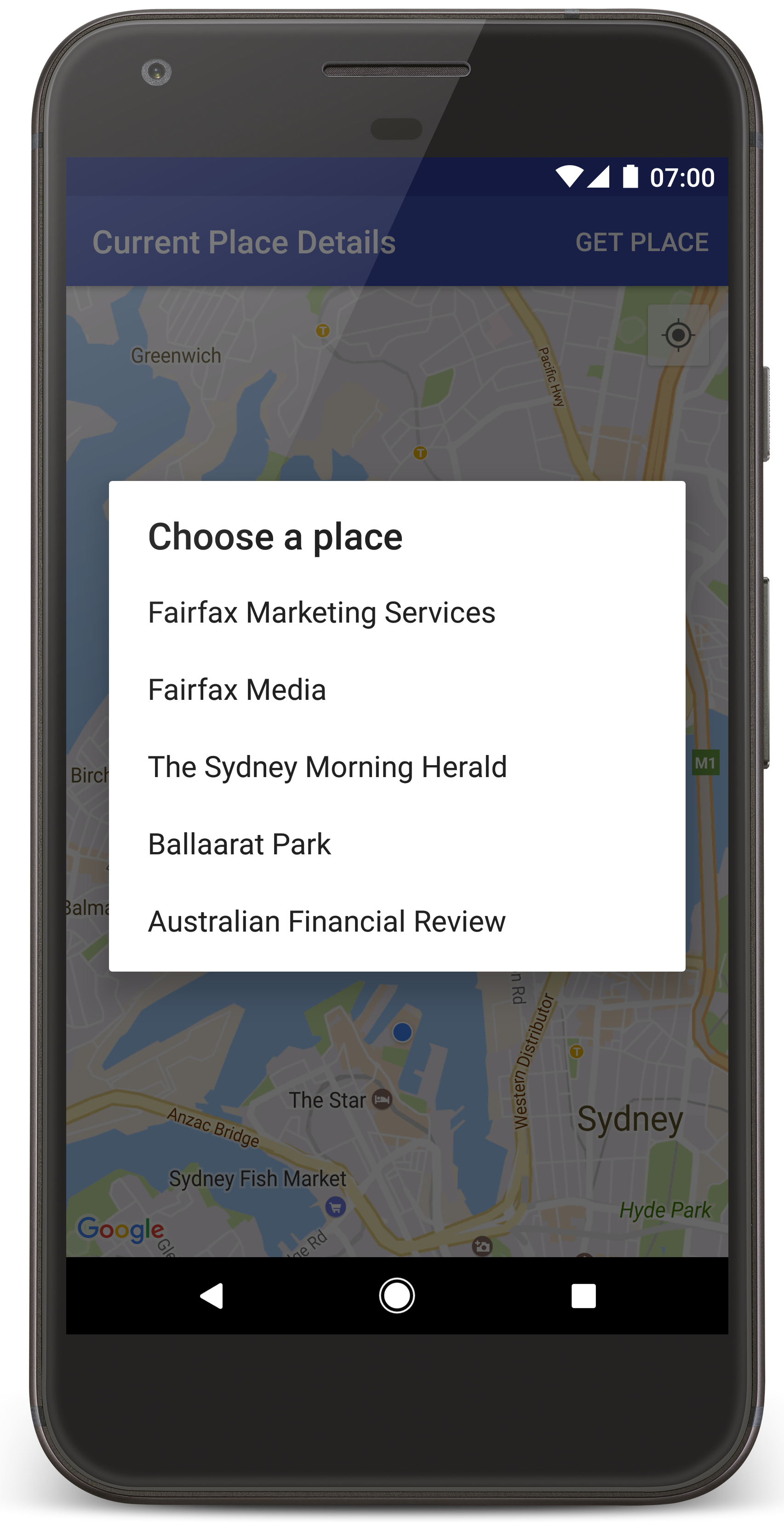
- Wählen Sie Get Place aus, um eine Liste mit Orten (Geschäften oder anderen POIs) in der Nähe Ihres aktuellen Standorts zu öffnen.
- Wählen Sie in der Liste einen Ort aus. In der Karte wird für den ausgewählten Ort eine Markierung eingefügt.
Fehlerbehebung:
- Wenn Sie keine Karte sehen, prüfen Sie, ob Sie einen API-Schlüssel erhalten und ihn wie oben beschrieben in die App eingefügt haben. Kontrollieren Sie, ob es im Protokoll im Android Monitor von Android Studio Fehlermeldungen zum API-Schlüssel gibt.
- Wenn auf der Karte nur eine einzelne Markierung auf der Sydney Harbour Bridge (dem in der App angegebenen Standardstandort) angezeigt wird, prüfen Sie, ob Sie der App eine Berechtigung zur Standortermittlung zugewiesen haben. Die App fordert diese Berechtigung zur Laufzeit an. Dabei wird das im Leitfaden zu Android-Berechtigungen beschriebene Muster befolgt. Sie können Berechtigungen auch direkt auf dem Gerät festlegen, indem Sie Einstellungen > Apps > App-Name > Berechtigungen > Standort auswählen. Ausführliche Informationen zum Umgang mit Berechtigungen in Ihrem Code finden Sie unten im Abschnitt Berechtigung zur Standortermittlung anfordern.
- Wenn Sie Protokolle aufrufen und Fehler in der App beheben möchten, können Sie dazu die Fehlerbehebungstools in Android Studio verwenden.
Code verstehen
In diesem Teil der Anleitung werden die wichtigsten Teile der App CurrentPlaceDetailsOnMap erläutert, damit Sie besser verstehen, wie Sie eine ähnliche App erstellen können.
Places API-Client instanziieren
Die folgenden Objekte sind die primären Einstiegspunkte für das Places SDK for Android:
- Mit der Klasse
Placeswerden Clients für das Places SDK for Android erstellt und verwaltet. - Über die Schnittstelle
PlacesClientwerden der aktuelle Standort des Geräts sowie die Orte in der Nähe des Standorts abgerufen.
Die Schnittstelle LocationServices ist der Haupteinstiegspunkt für Android-Standortdienste.
Wenn Sie die APIs nutzen möchten, führen Sie in der Methode onCreate() des Fragments oder der Aktivität folgende Schritte aus:
- Initialisieren Sie ein
Places-Objekt. - Erstellen Sie ein
PlacesClient-Objekt. - Erstellen Sie ein
FusedLocationProviderClient-Objekt.
Beispiel:
Java
@Override
protected void onCreate(Bundle savedInstanceState) {
    super.onCreate(savedInstanceState);

    // ...

    // Retrieve the content view that renders the map.
    setContentView(R.layout.activity_maps);

    // Construct a PlacesClient
    Places.initialize(getApplicationContext(), getString(R.string.maps_api_key));
    placesClient = Places.createClient(this);

    // Construct a FusedLocationProviderClient.
    fusedLocationProviderClient = LocationServices.getFusedLocationProviderClient(this);
}
Kotlin
override fun onCreate(savedInstanceState: Bundle?) {
    super.onCreate(savedInstanceState)

    // ...

    // Retrieve the content view that renders the map.
    setContentView(R.layout.activity_maps)

    // Construct a PlacesClient
    Places.initialize(applicationContext, getString(R.string.maps_api_key))
    placesClient = Places.createClient(this)

    // Construct a FusedLocationProviderClient.
    fusedLocationProviderClient = LocationServices.getFusedLocationProviderClient(this)

}
Berechtigung zur Standortermittlung anfordern
Um den Gerätestandort bestimmen und die Funktion zum Antippen der Schaltfläche Mein Standort auf der Karte für Nutzer freigeben zu können, muss über Ihre App eine Berechtigung zur Standortermittlung angefordert werden.
Diese Anleitung enthält den Code, den Sie zum Anfordern einer detaillierten Berechtigung zur Standortermittlung benötigen. Weitere Informationen finden Sie im Leitfaden zu Android-Berechtigungen.
Fügen Sie die Berechtigung als untergeordnetes Element des Elements
<manifest>in Ihrem Android-Manifest hinzu:<manifest xmlns:android="http://schemas.android.com/apk/res/android" package="com.example.currentplacedetailsonmap"> <uses-permission android:name="android.permission.ACCESS_FINE_LOCATION" /> </manifest>Fordern Sie in Ihrer App Laufzeitberechtigungen an und geben Sie dem Nutzer die Möglichkeit, die Berechtigung zur Standortermittlung zu erteilen oder abzulehnen. Mit dem folgenden Code wird überprüft, ob der Nutzer eine gültige Berechtigung zur Standortermittlung erteilt hat. Falls nicht, wird die Berechtigung angefordert:
Java
private void getLocationPermission() { /* * Request location permission, so that we can get the location of the * device. The result of the permission request is handled by a callback, * onRequestPermissionsResult. */ if (ContextCompat.checkSelfPermission(this.getApplicationContext(), android.Manifest.permission.ACCESS_FINE_LOCATION) == PackageManager.PERMISSION_GRANTED) { locationPermissionGranted = true; } else { ActivityCompat.requestPermissions(this, new String[]{android.Manifest.permission.ACCESS_FINE_LOCATION}, PERMISSIONS_REQUEST_ACCESS_FINE_LOCATION); } }Kotlin
private fun getLocationPermission() { /* * Request location permission, so that we can get the location of the * device. The result of the permission request is handled by a callback, * onRequestPermissionsResult. */ if (ContextCompat.checkSelfPermission(this.applicationContext, Manifest.permission.ACCESS_FINE_LOCATION) == PackageManager.PERMISSION_GRANTED) { locationPermissionGranted = true } else { ActivityCompat.requestPermissions(this, arrayOf(Manifest.permission.ACCESS_FINE_LOCATION), PERMISSIONS_REQUEST_ACCESS_FINE_LOCATION) } }Überschreiben Sie den Callback
onRequestPermissionsResult(), um das Ergebnis der Berechtigungsanfrage zu verarbeiten:Java
@Override public void onRequestPermissionsResult(int requestCode, @NonNull String[] permissions, @NonNull int[] grantResults) { locationPermissionGranted = false; if (requestCode == PERMISSIONS_REQUEST_ACCESS_FINE_LOCATION) {// If request is cancelled, the result arrays are empty. if (grantResults.length > 0 && grantResults[0] == PackageManager.PERMISSION_GRANTED) { locationPermissionGranted = true; } } else { super.onRequestPermissionsResult(requestCode, permissions, grantResults); } updateLocationUI(); }Kotlin
override fun onRequestPermissionsResult(requestCode: Int, permissions: Array<String>, grantResults: IntArray) { locationPermissionGranted = false when (requestCode) { PERMISSIONS_REQUEST_ACCESS_FINE_LOCATION -> { // If request is cancelled, the result arrays are empty. if (grantResults.isNotEmpty() && grantResults[0] == PackageManager.PERMISSION_GRANTED) { locationPermissionGranted = true } } else -> super.onRequestPermissionsResult(requestCode, permissions, grantResults) } updateLocationUI() }In einem späteren Abschnitt dieser Anleitung wird die Methode
updateLocationUI()beschrieben.
Karte hinzufügen
Rufen Sie mit dem Maps SDK for Android eine Karte auf.
Fügen Sie der Layoutdatei
activity_maps.xmlIhrer Aktivität ein<fragment>-Element hinzu. Mit diesem Element wird einSupportMapFragmentdefiniert, das als Container für die Karte fungiert und Zugriff auf dasGoogleMap-Objekt bietet. In der Anleitung wird die Version der Android Support Library des Kartenfragments verwendet, um die Abwärtskompatibilität mit früheren Versionen des Android-Frameworks sicherzustellen.<!-- Copyright 2020 Google LLC Licensed under the Apache License, Version 2.0 (the "License"); you may not use this file except in compliance with the License. You may obtain a copy of the License at http://www.apache.org/licenses/LICENSE-2.0 Unless required by applicable law or agreed to in writing, software distributed under the License is distributed on an "AS IS" BASIS, WITHOUT WARRANTIES OR CONDITIONS OF ANY KIND, either express or implied. See the License for the specific language governing permissions and limitations under the License. --> <fragment xmlns:android="http://schemas.android.com/apk/res/android" xmlns:tools="http://schemas.android.com/tools" android:id="@+id/map" android:name="com.google.android.gms.maps.SupportMapFragment" android:layout_width="match_parent" android:layout_height="match_parent" tools:context="com.example.currentplacedetailsonmap.MapsActivityCurrentPlace" />Legen Sie in der
onCreate()-Methode die Layoutdatei als Inhaltsansicht fest:Java
@Override protected void onCreate(Bundle savedInstanceState) { super.onCreate(savedInstanceState); // Retrieve the content view that renders the map. setContentView(R.layout.activity_maps); }Kotlin
override fun onCreate(savedInstanceState: Bundle?) { super.onCreate(savedInstanceState) // Retrieve the content view that renders the map. setContentView(R.layout.activity_maps) }Implementieren Sie die Schnittstelle
OnMapReadyCallbackund überschreiben Sie dieonMapReady()-Methode, um die Karte einzurichten, wenn dasGoogleMap-Objekt verfügbar ist:Java
@Override public void onMapReady(GoogleMap map) { this.map = map; // ... // Turn on the My Location layer and the related control on the map. updateLocationUI(); // Get the current location of the device and set the position of the map. getDeviceLocation(); }Kotlin
override fun onMapReady(map: GoogleMap) { this.map = map // ... // Turn on the My Location layer and the related control on the map. updateLocationUI() // Get the current location of the device and set the position of the map. getDeviceLocation() }Rufen Sie in der Methode
onCreate()Ihrer Aktivität einen Handle zum Kartenfragment ab, indem SieFragmentManager.findFragmentById()aufrufen. Registrieren Sie sich dann mitgetMapAsync()für den Karten-Callback:Java
SupportMapFragment mapFragment = (SupportMapFragment) getSupportFragmentManager() .findFragmentById(R.id.map); mapFragment.getMapAsync(this);Kotlin
val mapFragment = supportFragmentManager .findFragmentById(R.id.map) as SupportMapFragment? mapFragment?.getMapAsync(this)Schreiben Sie eine
updateLocationUI()-Methode, um die Standortsteuerelemente auf der Karte festzulegen. Wenn der Nutzer die Berechtigung zur Standortermittlung erteilt hat, aktivieren Sie die Ebene „Mein Standort“ und das entsprechende Steuerelement auf der Karte. Deaktivieren Sie andernfalls die Ebene und das Steuerelement und setzen Sie den aktuellen Standort auf „null“:Java
private void updateLocationUI() { if (map == null) { return; } try { if (locationPermissionGranted) { map.setMyLocationEnabled(true); map.getUiSettings().setMyLocationButtonEnabled(true); } else { map.setMyLocationEnabled(false); map.getUiSettings().setMyLocationButtonEnabled(false); lastKnownLocation = null; getLocationPermission(); } } catch (SecurityException e) { Log.e("Exception: %s", e.getMessage()); } }Kotlin
@SuppressLint("MissingPermission") private fun updateLocationUI() { if (map == null) { return } try { if (locationPermissionGranted) { map?.isMyLocationEnabled = true map?.uiSettings?.isMyLocationButtonEnabled = true } else { map?.isMyLocationEnabled = false map?.uiSettings?.isMyLocationButtonEnabled = false lastKnownLocation = null getLocationPermission() } } catch (e: SecurityException) { Log.e("Exception: %s", e.message, e) } }
Standort des Android-Geräts abrufen und Karte positionieren
Verwenden Sie den Anbieter für kombinierte Standortbestimmung, um den zuletzt bekannten Standort des Geräts zu finden, und nutzen Sie den Standort dann, um die Karte zu positionieren. Die Anleitung enthält den Code, den Sie benötigen. Weitere Informationen zum Abrufen des Gerätestandorts finden Sie in der Referenz zur FusedLocationProviderApi in den Standort-APIs der Google Play-Dienste.
Java
private void getDeviceLocation() {
/*
* Get the best and most recent location of the device, which may be null in rare
* cases when a location is not available.
*/
try {
if (locationPermissionGranted) {
Task<Location> locationResult = fusedLocationProviderClient.getLastLocation();
locationResult.addOnCompleteListener(this, new OnCompleteListener<Location>() {
@Override
public void onComplete(@NonNull Task<Location> task) {
if (task.isSuccessful()) {
// Set the map's camera position to the current location of the device.
lastKnownLocation = task.getResult();
if (lastKnownLocation != null) {
map.moveCamera(CameraUpdateFactory.newLatLngZoom(
new LatLng(lastKnownLocation.getLatitude(),
lastKnownLocation.getLongitude()), DEFAULT_ZOOM));
}
} else {
Log.d(TAG, "Current location is null. Using defaults.");
Log.e(TAG, "Exception: %s", task.getException());
map.moveCamera(CameraUpdateFactory
.newLatLngZoom(defaultLocation, DEFAULT_ZOOM));
map.getUiSettings().setMyLocationButtonEnabled(false);
}
}
});
}
} catch (SecurityException e) {
Log.e("Exception: %s", e.getMessage(), e);
}
}
Kotlin
@SuppressLint("MissingPermission")
private fun getDeviceLocation() {
/*
* Get the best and most recent location of the device, which may be null in rare
* cases when a location is not available.
*/
try {
if (locationPermissionGranted) {
val locationResult = fusedLocationProviderClient.lastLocation
locationResult.addOnCompleteListener(this) { task ->
if (task.isSuccessful) {
// Set the map's camera position to the current location of the device.
lastKnownLocation = task.result
if (lastKnownLocation != null) {
map?.moveCamera(CameraUpdateFactory.newLatLngZoom(
LatLng(lastKnownLocation!!.latitude,
lastKnownLocation!!.longitude), DEFAULT_ZOOM.toFloat()))
}
} else {
Log.d(TAG, "Current location is null. Using defaults.")
Log.e(TAG, "Exception: %s", task.exception)
map?.moveCamera(CameraUpdateFactory
.newLatLngZoom(defaultLocation, DEFAULT_ZOOM.toFloat()))
map?.uiSettings?.isMyLocationButtonEnabled = false
}
}
}
} catch (e: SecurityException) {
Log.e("Exception: %s", e.message, e)
}
}
Aktuellen Ort abrufen
Verwenden Sie das Places SDK for Android, um eine Liste von Orten abzurufen, die sich am aktuellen Standort befinden. In diesem Zusammenhang ist ein Ort ein Geschäft oder ein anderer POI.
In dieser Anleitung wird der aktuelle Ort abgerufen, wenn der Nutzer auf die Schaltfläche Get Place (Ort abrufen) klickt. Dem Nutzer wird eine Liste mit möglichen Orten zur Auswahl angezeigt. Dann wird an der Position des ausgewählten Orts eine Markierung erstellt. Die Anleitung enthält den Code, den Sie für die Interaktion mit dem Places SDK for Android benötigen. Weitere Informationen finden Sie in der Anleitung zum Abrufen des aktuellen Orts.
- Erstellen Sie eine Layoutdatei (
current_place_menu.xml) für das Optionsmenü und überschreiben Sie dieonCreateOptionsMenu()-Methode, um das Optionsmenü einzurichten. Entsprechenden Code finden Sie in der zugehörigen Beispiel-App. - Überschreiben Sie die Methode
onOptionsItemSelected(), um den aktuellen Ort abzurufen, wenn der Nutzer auf die Option Get Place (Ort abrufen) klickt:Java
@Override public boolean onOptionsItemSelected(MenuItem item) { if (item.getItemId() == R.id.option_get_place) { showCurrentPlace(); } return true; }Kotlin
override fun onOptionsItemSelected(item: MenuItem): Boolean { if (item.itemId == R.id.option_get_place) { showCurrentPlace() } return true } Erstellen Sie eine
showCurrentPlace()-Methode, um eine Liste mit Orten abzurufen, die sich am aktuellen Standort befinden:Java
private void showCurrentPlace() { if (map == null) { return; } if (locationPermissionGranted) { // Use fields to define the data types to return. List<Place.Field> placeFields = Arrays.asList(Place.Field.NAME, Place.Field.ADDRESS, Place.Field.LAT_LNG); // Use the builder to create a FindCurrentPlaceRequest. FindCurrentPlaceRequest request = FindCurrentPlaceRequest.newInstance(placeFields); // Get the likely places - that is, the businesses and other points of interest that // are the best match for the device's current location. @SuppressWarnings("MissingPermission") final Task<FindCurrentPlaceResponse> placeResult = placesClient.findCurrentPlace(request); placeResult.addOnCompleteListener (new OnCompleteListener<FindCurrentPlaceResponse>() { @Override public void onComplete(@NonNull Task<FindCurrentPlaceResponse> task) { if (task.isSuccessful() && task.getResult() != null) { FindCurrentPlaceResponse likelyPlaces = task.getResult(); // Set the count, handling cases where less than 5 entries are returned. int count; if (likelyPlaces.getPlaceLikelihoods().size() < M_MAX_ENTRIES) { count = likelyPlaces.getPlaceLikelihoods().size(); } else { count = M_MAX_ENTRIES; } int i = 0; likelyPlaceNames = new String[count]; likelyPlaceAddresses = new String[count]; likelyPlaceAttributions = new List[count]; likelyPlaceLatLngs = new LatLng[count]; for (PlaceLikelihood placeLikelihood : likelyPlaces.getPlaceLikelihoods()) { // Build a list of likely places to show the user. likelyPlaceNames[i] = placeLikelihood.getPlace().getName(); likelyPlaceAddresses[i] = placeLikelihood.getPlace().getAddress(); likelyPlaceAttributions[i] = placeLikelihood.getPlace() .getAttributions(); likelyPlaceLatLngs[i] = placeLikelihood.getPlace().getLatLng(); i++; if (i > (count - 1)) { break; } } // Show a dialog offering the user the list of likely places, and add a // marker at the selected place. MapsActivityCurrentPlace.this.openPlacesDialog(); } else { Log.e(TAG, "Exception: %s", task.getException()); } } }); } else { // The user has not granted permission. Log.i(TAG, "The user did not grant location permission."); // Add a default marker, because the user hasn't selected a place. map.addMarker(new MarkerOptions() .title(getString(R.string.default_info_title)) .position(defaultLocation) .snippet(getString(R.string.default_info_snippet))); // Prompt the user for permission. getLocationPermission(); } }Kotlin
@SuppressLint("MissingPermission") private fun showCurrentPlace() { if (map == null) { return } if (locationPermissionGranted) { // Use fields to define the data types to return. val placeFields = listOf(Place.Field.NAME, Place.Field.ADDRESS, Place.Field.LAT_LNG) // Use the builder to create a FindCurrentPlaceRequest. val request = FindCurrentPlaceRequest.newInstance(placeFields) // Get the likely places - that is, the businesses and other points of interest that // are the best match for the device's current location. val placeResult = placesClient.findCurrentPlace(request) placeResult.addOnCompleteListener { task -> if (task.isSuccessful && task.result != null) { val likelyPlaces = task.result // Set the count, handling cases where less than 5 entries are returned. val count = if (likelyPlaces != null && likelyPlaces.placeLikelihoods.size < M_MAX_ENTRIES) { likelyPlaces.placeLikelihoods.size } else { M_MAX_ENTRIES } var i = 0 likelyPlaceNames = arrayOfNulls(count) likelyPlaceAddresses = arrayOfNulls(count) likelyPlaceAttributions = arrayOfNulls<List<*>?>(count) likelyPlaceLatLngs = arrayOfNulls(count) for (placeLikelihood in likelyPlaces?.placeLikelihoods ?: emptyList()) { // Build a list of likely places to show the user. likelyPlaceNames[i] = placeLikelihood.place.name likelyPlaceAddresses[i] = placeLikelihood.place.address likelyPlaceAttributions[i] = placeLikelihood.place.attributions likelyPlaceLatLngs[i] = placeLikelihood.place.latLng i++ if (i > count - 1) { break } } // Show a dialog offering the user the list of likely places, and add a // marker at the selected place. openPlacesDialog() } else { Log.e(TAG, "Exception: %s", task.exception) } } } else { // The user has not granted permission. Log.i(TAG, "The user did not grant location permission.") // Add a default marker, because the user hasn't selected a place. map?.addMarker(MarkerOptions() .title(getString(R.string.default_info_title)) .position(defaultLocation) .snippet(getString(R.string.default_info_snippet))) // Prompt the user for permission. getLocationPermission() } }Erstellen Sie eine
openPlacesDialog()-Methode, um ein Formular einzublenden, über das der Nutzer einen Ort aus einer Liste wahrscheinlicher Orte auswählen kann. Erstellen Sie auf der Karte eine Markierung für den ausgewählten Ort. Die Markierung enthält den Namen und die Adresse des Orts sowie alle Quellenangaben, die von der API zur Verfügung gestellt werden:Java
private void openPlacesDialog() { // Ask the user to choose the place where they are now. DialogInterface.OnClickListener listener = new DialogInterface.OnClickListener() { @Override public void onClick(DialogInterface dialog, int which) { // The "which" argument contains the position of the selected item. LatLng markerLatLng = likelyPlaceLatLngs[which]; String markerSnippet = likelyPlaceAddresses[which]; if (likelyPlaceAttributions[which] != null) { markerSnippet = markerSnippet + "\n" + likelyPlaceAttributions[which]; } // Add a marker for the selected place, with an info window // showing information about that place. map.addMarker(new MarkerOptions() .title(likelyPlaceNames[which]) .position(markerLatLng) .snippet(markerSnippet)); // Position the map's camera at the location of the marker. map.moveCamera(CameraUpdateFactory.newLatLngZoom(markerLatLng, DEFAULT_ZOOM)); } }; // Display the dialog. AlertDialog dialog = new AlertDialog.Builder(this) .setTitle(R.string.pick_place) .setItems(likelyPlaceNames, listener) .show(); }Kotlin
private fun openPlacesDialog() { // Ask the user to choose the place where they are now. val listener = DialogInterface.OnClickListener { dialog, which -> // The "which" argument contains the position of the selected item. val markerLatLng = likelyPlaceLatLngs[which] var markerSnippet = likelyPlaceAddresses[which] if (likelyPlaceAttributions[which] != null) { markerSnippet = """ $markerSnippet ${likelyPlaceAttributions[which]} """.trimIndent() } if (markerLatLng == null) { return@OnClickListener } // Add a marker for the selected place, with an info window // showing information about that place. map?.addMarker(MarkerOptions() .title(likelyPlaceNames[which]) .position(markerLatLng) .snippet(markerSnippet)) // Position the map's camera at the location of the marker. map?.moveCamera(CameraUpdateFactory.newLatLngZoom(markerLatLng, DEFAULT_ZOOM.toFloat())) } // Display the dialog. AlertDialog.Builder(this) .setTitle(R.string.pick_place) .setItems(likelyPlaceNames, listener) .show() }Erstellen Sie ein benutzerdefiniertes Layout für den Inhalt des Infofensters. Dadurch erhalten Sie in diesem Fenster mehrere Inhaltszeilen. Fügen Sie zuerst die XML-Layoutdatei
custom_info_contents.xmlhinzu, die eine Textansicht für den Titel des Infofensters enthält, und dann eine weitere Textansicht für das Snippet, also den Textinhalt dieses Fensters:<?xml version="1.0" encoding="utf-8"?> <!-- Copyright 2020 Google LLC Licensed under the Apache License, Version 2.0 (the "License"); you may not use this file except in compliance with the License. You may obtain a copy of the License at http://www.apache.org/licenses/LICENSE-2.0 Unless required by applicable law or agreed to in writing, software distributed under the License is distributed on an "AS IS" BASIS, WITHOUT WARRANTIES OR CONDITIONS OF ANY KIND, either express or implied. See the License for the specific language governing permissions and limitations under the License. --> <LinearLayout xmlns:android="http://schemas.android.com/apk/res/android" android:layout_width="wrap_content" android:layout_height="wrap_content" android:layoutDirection="locale" android:orientation="vertical"> <TextView android:id="@+id/title" android:layout_width="wrap_content" android:layout_height="wrap_content" android:layout_gravity="center_horizontal" android:textColor="#ff000000" android:textStyle="bold" /> <TextView android:id="@+id/snippet" android:layout_width="wrap_content" android:layout_height="wrap_content" android:textColor="#ff7f7f7f" /> </LinearLayout>Implementieren Sie die Schnittstelle
InfoWindowAdapter, um eine Layout-Inflation durchzuführen und den Inhalt des Infofensters zu laden.Java
// Use a custom info window adapter to handle multiple lines of text in the // info window contents. this.map.setInfoWindowAdapter(new GoogleMap.InfoWindowAdapter() { @Override // Return null here, so that getInfoContents() is called next. public View getInfoWindow(Marker arg0) { return null; } @Override public View getInfoContents(Marker marker) { // Inflate the layouts for the info window, title and snippet. View infoWindow = getLayoutInflater().inflate(R.layout.custom_info_contents, (FrameLayout) findViewById(R.id.map), false); TextView title = infoWindow.findViewById(R.id.title); title.setText(marker.getTitle()); TextView snippet = infoWindow.findViewById(R.id.snippet); snippet.setText(marker.getSnippet()); return infoWindow; } });Kotlin
// Use a custom info window adapter to handle multiple lines of text in the // info window contents. this.map?.setInfoWindowAdapter(object : InfoWindowAdapter { // Return null here, so that getInfoContents() is called next. override fun getInfoWindow(arg0: Marker): View? { return null } override fun getInfoContents(marker: Marker): View { // Inflate the layouts for the info window, title and snippet. val infoWindow = layoutInflater.inflate(R.layout.custom_info_contents, findViewById<FrameLayout>(R.id.map), false) val title = infoWindow.findViewById<TextView>(R.id.title) title.text = marker.title val snippet = infoWindow.findViewById<TextView>(R.id.snippet) snippet.text = marker.snippet return infoWindow } })
Status der Karte speichern
Speichern Sie die Kameraposition und den Gerätestandort. Wenn ein Nutzer ein Android-Gerät dreht oder die Konfiguration ändert, wird die Kartenaktivität durch das Android-Framework zerstört und wieder neu erstellt. Damit dieser Ablauf flüssiger wird, sollten Sie den Status der relevanten App speichern und bei Bedarf wiederherstellen.
In dieser Anleitung finden Sie den gesamten Code, der erforderlich ist, um den Status der Karte zu speichern. Weitere Informationen finden Sie in der Anleitung zum savedInstanceState-Paket.
Richten Sie in Ihrer Kartenaktivität Schlüssel/Wert-Paare ein, um den Status der Aktivität zu speichern:
Java
private static final String KEY_CAMERA_POSITION = "camera_position"; private static final String KEY_LOCATION = "location";
Kotlin
private const val KEY_CAMERA_POSITION = "camera_position" private const val KEY_LOCATION = "location"
Implementieren Sie den
onSaveInstanceState()-Callback, um den Status zu speichern, wenn die Aktivität pausiert:Java
@Override protected void onSaveInstanceState(Bundle outState) { if (map != null) { outState.putParcelable(KEY_CAMERA_POSITION, map.getCameraPosition()); outState.putParcelable(KEY_LOCATION, lastKnownLocation); } super.onSaveInstanceState(outState); }Kotlin
override fun onSaveInstanceState(outState: Bundle) { map?.let { map -> outState.putParcelable(KEY_CAMERA_POSITION, map.cameraPosition) outState.putParcelable(KEY_LOCATION, lastKnownLocation) } super.onSaveInstanceState(outState) }Rufen Sie in der
onCreate()-Methode Ihrer Aktivität den Standort des Geräts und die Kameraposition der Karte ab, falls sie zuvor gespeichert wurden:Java
// Retrieve location and camera position from saved instance state. if (savedInstanceState != null) { lastKnownLocation = savedInstanceState.getParcelable(KEY_LOCATION); cameraPosition = savedInstanceState.getParcelable(KEY_CAMERA_POSITION); }Kotlin
if (savedInstanceState != null) { lastKnownLocation = savedInstanceState.getParcelable(KEY_LOCATION) cameraPosition = savedInstanceState.getParcelable(KEY_CAMERA_POSITION) }