## Overview
**web** **iOS** **API**
Google Maps Platform is available for web (JS, TS), Android, and iOS,
and also offers web services APIs for getting information about places, directions,
and distances. The samples in this guide are written for one platform, but
documentation links are provided for implementation on other platforms.
When your users see your products online, they want to find the best and most
convenient way to get their order. The Product Locator implementation guide
and customization tips are what Google recommends as the
optimal combination of Google Maps Platform APIs to build great product
locator user experiences.
Following this implementation guide, you can help customers see the detailed
information they need to find your products, and give them directions to the
store that has their item, whether they're driving, cycling, walking, or taking
public transit.
[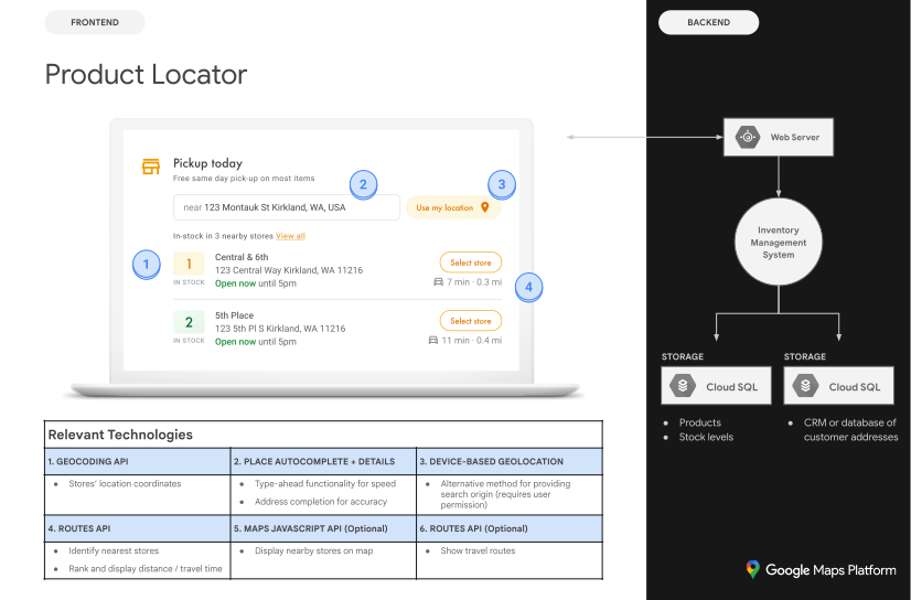](https://developers.google.com/static/maps/architecture/product-locator/images/diagram.svg) Architectural diagram (click to enlarge)
### Enable APIs
To implement Product Locator, you must enable the following APIs in the
Google Cloud console. The following hyperlinks send you to the Google Cloud console
to enable each API for your selected project:
- [Maps JavaScript API](https://console.cloud.google.com/apis/library/maps-backend.googleapis.com)
- [Places API (New)](https://console.cloud.google.com/apis/library/places.googleapis.com)
- [Geocoding API](https://console.cloud.google.com/apis/library/geocoding-backend.googleapis.com)
- [Routes API](https://console.cloud.google.com/apis/library/routes.googleapis.com)
For more information about setup, see [Getting
started with Google Maps Platform](https://developers.google.com/maps/get-started).
### Implementation guide sections
The following implementations and customizations are covered here:
- The check mark icon is a core implementation step.
- The star icon is an optional but recommended customization to enhance the solution.
|---|---|---|
| | [Associate store locations with Google Maps Platform places](https://developers.google.com/maps/architecture/product-locator.md.txt#match_location_data) | Match a store location with a place in Google Maps Platform. |
| | [Identify the user's location](https://developers.google.com/maps/architecture/product-locator.md.txt#user_location) | Add type-as-you-go functionality to improve the user experience on all platforms and improve address accuracy with minimum keystrokes. |
| | [Identify the closest stores](https://developers.google.com/maps/architecture/product-locator.md.txt#identify_stores) | Calculate the travel distance and travel time for multiple origins and destinations, optionally specifying various forms of transport such as walking, driving, public transit, or cycling. |
| | [Display store information](https://developers.google.com/maps/architecture/product-locator.md.txt#display_stores) | Show data-rich information on your stores, so users can navigate to them more easily. |
| | [Provide navigation directions](https://developers.google.com/maps/architecture/product-locator.md.txt#get_directions) | Get directions data from origin to destination using various forms of transport such as walking, driving, cycling, and public transit. |
| | [Send directions to mobile](https://developers.google.com/maps/architecture/product-locator.md.txt#send_mobile_directions) | In addition to showing directions on your webpage, you can also send directions to a user's phone for navigation using Google Maps on the go. |
| | [Show your locations on an interactive map](https://developers.google.com/maps/architecture/product-locator.md.txt#show_locations) | Create custom map markers to help your locations stand out, and style the map to match your brand colors. Display (or hide) specific points of interest (POI) on your map to help users better orient themselves, and control POI density to prevent map clutter. |
| | [Combine custom location data with Place Details](https://developers.google.com/maps/architecture/product-locator.md.txt#combine_location_data) | Combine your own custom location details with Place Details to give users a rich set of data for making decisions. |
> [!NOTE]
> **Note:** To track adoption of solution code samples and improve solution quality, Google includes the `solution_channel` query parameter in API calls in the sample code provided on this page. To opt-out, delete the `solution_channel` query parameter from the sample code. See [Google Maps Platform solutions parameter](https://developers.google.com/maps/reporting-and-monitoring/reporting.md.txt#solutions-usage) for more information.
## Associate store locations with Google Maps Platform places
### Get place IDs
|---|---|
| **This example uses:** [Places API (New)](https://developers.google.com/maps/documentation/places/web-service/text-search.md.txt) | **Also available:** [JavaScript](https://developers.google.com/maps/documentation/javascript/place-search.md.txt) |
You'll find that you have a database of your stores with basic information
like the name of that location, its address, and its phone number, and you'd
like to associate it with a place in Google Maps Platform as a set of final
destinations your users can pick up products. To fetch the information that
Google Maps Platform has about that place, including geographic coordinates
and user-contributed information, find the
[place ID](https://developers.google.com/maps/documentation/places/web-service/place-id.md.txt#id-overview)
that corresponds to each of the stores in your database. You can make a call to
the [Text Search (New) endpoint](https://developers.google.com/maps/documentation/places/web-service/text-search.md.txt) in Places API (New) and
request only the `places.id` field in the field mask (which triggers
the [Text
Search Essentials IDs Only SKU](https://developers.google.com/maps/billing-and-pricing/sku-details/places#places_text-search-id-only-ess-sku)).
The following shows an example of requesting the place ID for the Google London
office:
```
curl -X POST -d '{
"textQuery" : "Google London"
}' \
-H 'Content-Type: application/json' \
-H 'X-Goog-Api-Key: YOUR_API_KEY' \
-H 'X-Goog-FieldMask: places.id' \
'https://places.googleapis.com/v1/places:searchText'
```
You can [store this place ID](https://developers.google.com/maps/documentation/places/web-service/place-id.md.txt#save-id)
in your database with the rest of your store data and use it as an efficient way
to request information about the store. Following are instructions for using the
place ID to geocode, retrieve Place Details, and request directions to the
place.
### Geocode your locations
|---|---|
| **This example uses:** [Geocoding API](https://developers.google.com/maps/documentation/geocoding) | **Also available:** [JavaScript](https://developers.google.com/maps/documentation/javascript/geocoding.md.txt) |
If your database of stores has street addresses but not geographic coordinates,
use the Geocoding API to obtain the latitude and longitude of that
address for the purposes of calculating which stores are nearest to your
customer. You can geocode the store on the server side, store the latitudes
and longitudes in your database, and
[refresh
at least every 30 days](https://cloud.google.com/maps-platform/terms/maps-service-terms#3.-geocoding-api).
Here is an example of using the Geocoding API to obtain the
latitude and longitude of the place ID that was returned for the Google London
office:
```html
https://maps.googleapis.com/maps/api/geocode/json?place_id=ChIJVSZzVR8FdkgRTyQkxxLQmVU&key=YOUR_API_KEY&solution_channel=GMP_guides_productlocator_v1_a
```
## Identify the user's location
|---|---|
| **This example uses:** [Place Autocomplete in the Maps JavaScript API](https://developers.google.com/maps/documentation/javascript/place-autocomplete-new.md.txt) | **Also available:** [Android](https://developers.google.com/maps/documentation/places/android-sdk/place-autocomplete.md.txt) \| [iOS](https://developers.google.com/maps/documentation/places/ios-sdk/place-autocomplete.md.txt) |
A key component in Product Locator is identifying your user's starting
location. You can offer two options for the user to specify their starting
location: typing in the origin of their search, or granting permissions to web
browser geolocation or mobile location services.
### Handle typed entries using autocomplete
Today's users are accustomed to the autocomplete type-ahead functionality on the
consumer version of Google Maps. This functionality can be integrated into any
application using the Google Maps Platform Places libraries on mobile devices
and the web. When a user types an address, autocomplete fills in the rest
through the use of widgets. You can also provide your own autocomplete
functionality using the
[Place
Autocomplete Data API](https://developers.google.com/maps/documentation/javascript/place-autocomplete-data) directly.
[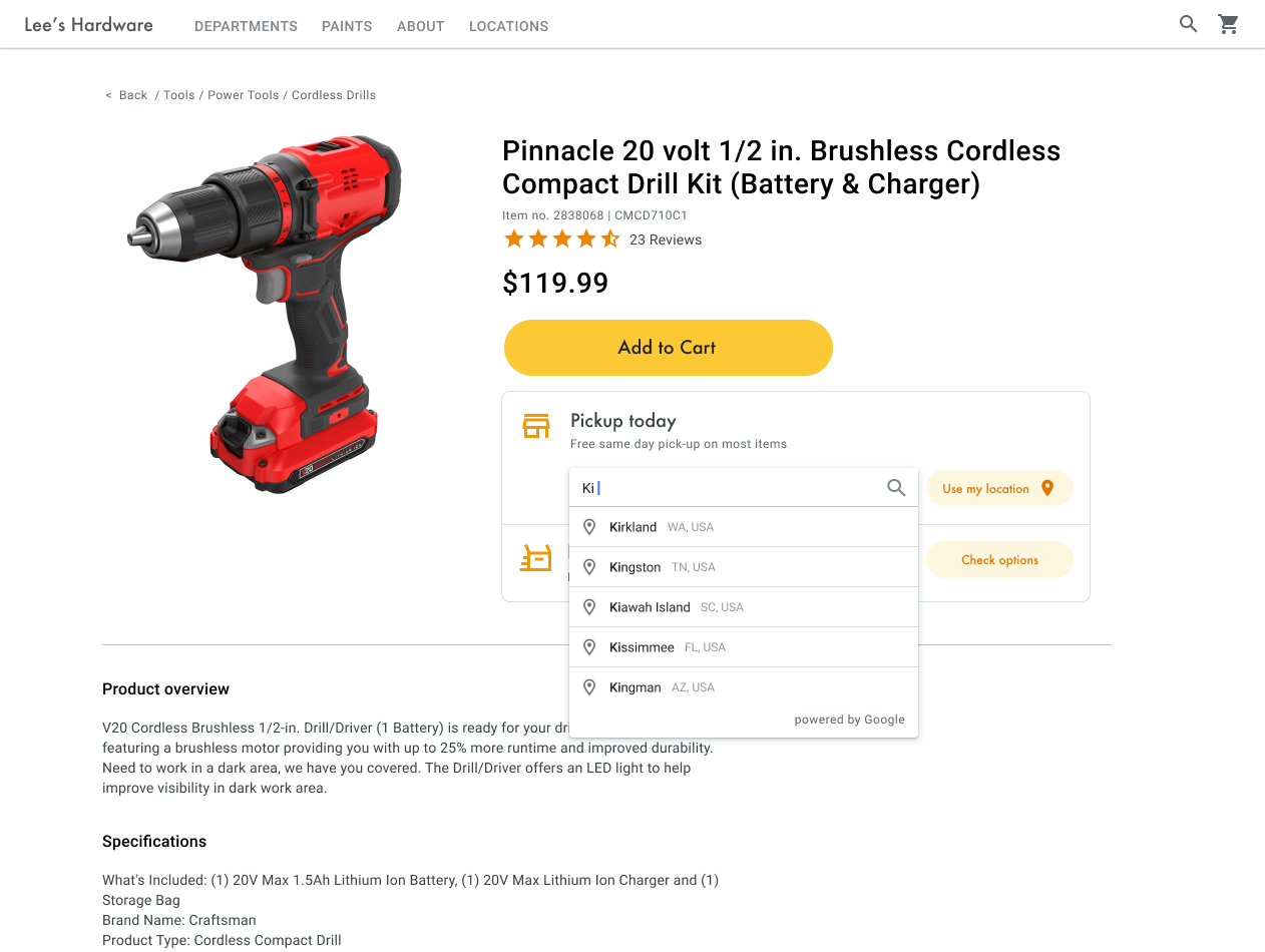](https://developers.google.com/static/maps/architecture/product-locator/images/address-entry-2.png) Address autocomplete functionality (click to enlarge)
In the following example, add the Places and Marker libraries to your site by
adding the `libraries=places,marker` parameter to the
Maps JavaScript API script URL.
Next, add a container element to your page where the
[`PlaceAutocompleteElement`](https://developers.google.com/maps/documentation/javascript/reference/places-widget.md.txt#PlaceAutocompleteElement)
widget will be appended:
Finally, initialize the `PlaceAutocompleteElement` widget and append
it to the container. Constraining the
[Place
Autocomplete predictions](https://developers.google.com/maps/documentation/javascript/place-autocomplete-new)
with `includedPrimaryTypes: ["geocode"]` configures the widget to
accept street addresses, neighborhoods, cities, and zip codes so users can input
any level of specificity to describe their origin. When a user selects a
prediction, the `gmp-select` event fires and you can call
`place.fetchFields()` to request the `location` field
containing the latitude and longitude of the user's origin. You'll use these map
coordinates to indicate the relationship of your locations to the origin.
```
// Create the PlaceAutocompleteElement, restricting predictions to
// geographical location types in the United Kingdom.
const placeAutocomplete = new google.maps.places.PlaceAutocompleteElement({
includedPrimaryTypes: ["geocode"],
includedRegionCodes: ["gb"],
});
placeAutocomplete.placeholder = "Enter starting address, city, or zip code";
document.getElementById("autocomplete-container").appendChild(placeAutocomplete);
// When the user selects an address from the drop-down,
// fetch the place details and search for the nearest stores.
placeAutocomplete.addEventListener("gmp-select", async ({ placePrediction }) => {
const place = placePrediction.toPlace();
await place.fetchFields({
fields: ["id", "location", "formattedAddress"],
});
searchFromOrigin(place);
});
}
```
In this example, once the user selects the address, the
`searchFromOrigin()` function starts. This takes the location of
the matched result that is the user location, then searches for nearest
locations based on those coordinates as the origin, discussed in the
[Identify the closest stores](https://developers.google.com/maps/architecture/product-locator.md.txt#identify_stores) section.
[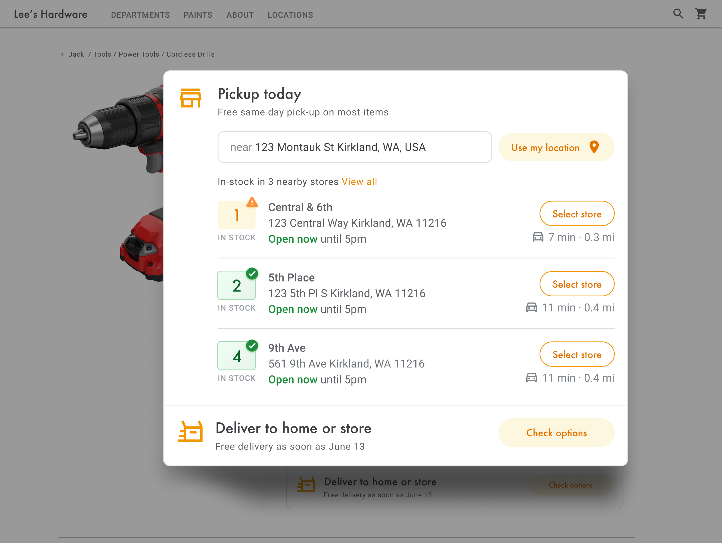](https://developers.google.com/static/maps/architecture/product-locator/images/view-inventory-location-granted.png) Show location options (click to enlarge)
#### Expand this to see video walkthroughs of adding Place
Autocomplete to your app:
### Website
[Video](https://www.youtube.com/watch?v=c3MjU9E9buQ)
### Android apps
[Video](https://www.youtube.com/watch?v=nDC-frkH_LA)
### iOS apps
[Video](https://www.youtube.com/watch?v=MEuqZQ-_WfQ)
### Use browser geolocation
To request and handle HTML5 browser geolocation, see how to
[enable a **Use my location** window](https://developers.google.com/maps/documentation/javascript/geolocation.md.txt):
[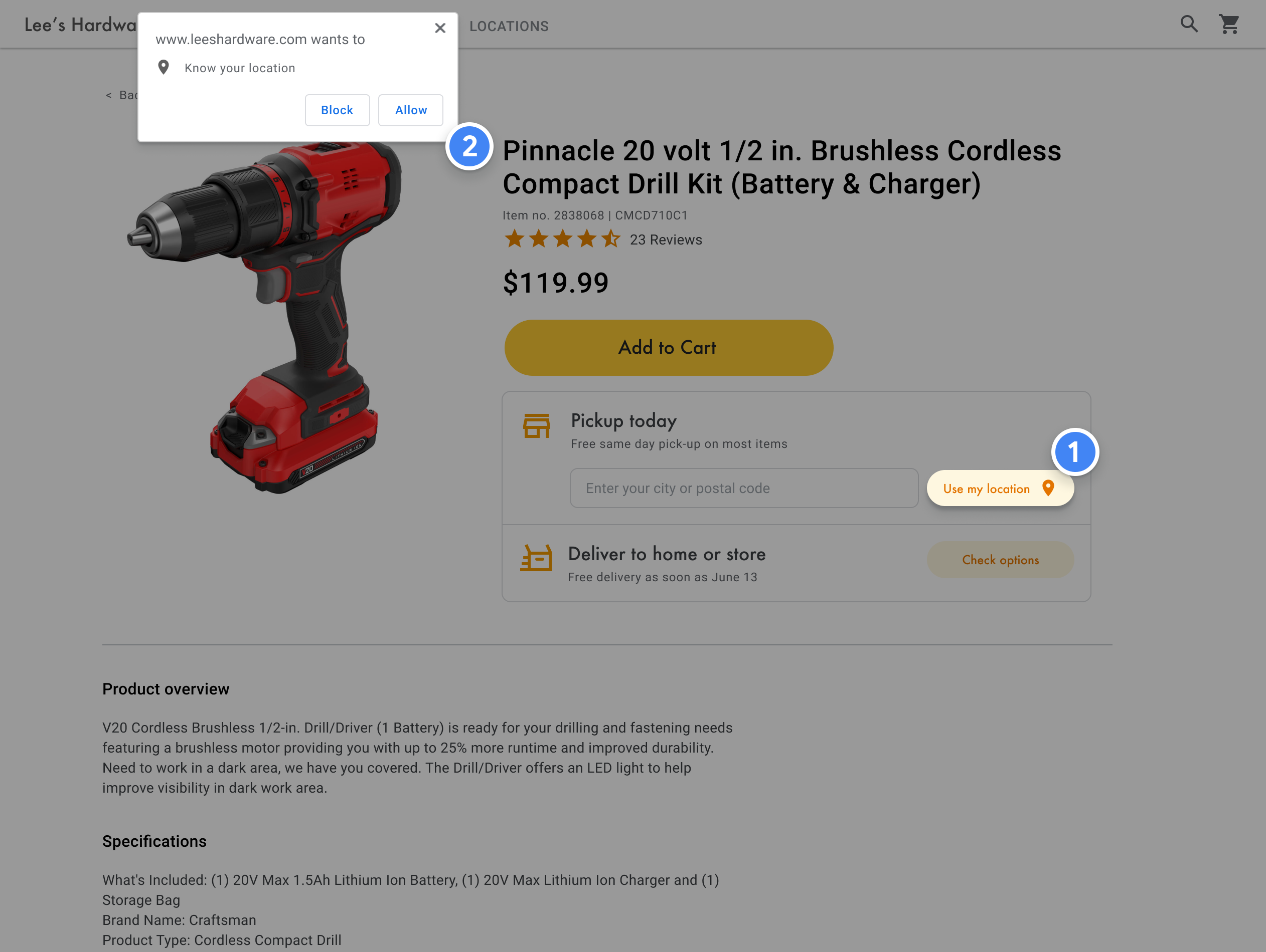](https://developers.google.com/static/maps/architecture/product-locator/images/location-permission.png) Web browser permission request (click to enlarge)
## Identify the closest stores
|---|---|
| **This example uses:** [Routes Library, Maps JavaScript API](https://developers.google.com/maps/documentation/javascript/routes/get-a-route-matrix.md.txt) | **Also available:** [Routes API](https://developers.google.com/maps/documentation/routes/compute_route_matrix.md.txt) |
Once you have the location of the user, you can compare this to where your store
locations are. Doing this with the
[`RouteMatrix`
class](https://developers.google.com/maps/documentation/javascript/routes/route-matrix-class-overview) in the Routes Library, Maps JavaScript API (or the
[Compute Route
Matrix](https://developers.google.com/maps/documentation/routes/compute-route-matrix-over) feature in the Routes API) helps your users select the
location that's most convenient for them by driving time or road distance.
The standard way of organizing a list of locations is by sorting them by
distance. Often this distance is calculated simply by using the straight line
from a user to the location, but this can be misleading. The straight line might
be over an impassable river or through busy roads at a time when another
location might be more convenient. This is important when you have multiple
locations within a few kilometers of each other.
The `RouteMatrix.computeRouteMatrix` method works by taking a list of
origin and destination locations and returning not only the travel distance but
also the travel time between them. In a user's case, the origin would be where
they currently are, or their desired starting point, and the destinations would
be that of the locations. Origins and destinations can be specified as
coordinate pairs, place IDs, or addresses. You can use
`RouteMatrix.computeRouteMatrix` with routing preferences such as
`TRAFFIC_AWARE` to show results based on current or future driving
times.
The following example calls `RouteMatrix.computeRouteMatrix` in the
Routes Library, Maps JavaScript API, specifying the user's origin and up to 25 store
locations at a time.
```
async function getDistances(originLocation) {
const { RouteMatrix } = await google.maps.importLibrary("routes");
const request = {
origins: [originLocation],
destinations: stores.slice(0, 25).map((store) => store.location),
travelMode: google.maps.TravelMode.DRIVING,
routingPreference: "TRAFFIC_AWARE",
fields: ["distanceMeters", "durationMillis", "condition"],
};
return RouteMatrix.computeRouteMatrix(request);
}
function update(location) {
if (!location) {
return;
}
// ...
// sort by spherical distance
stores.sort((a, b) => {
return (
google.maps.geometry.spherical.computeDistanceBetween(
new google.maps.LatLng(a.location),
location
) -
google.maps.geometry.spherical.computeDistanceBetween(
new google.maps.LatLng(b.location),
location
)
);
});
// display travel distance and time
getDistances(location)
.then(({ matrix }) => {
const items = matrix.rows[0].items;
for (let i = 0; i < items.length; i++) {
if (items[i].condition === "ROUTE_EXISTS") {
stores[i].travelDistance = items[i].distanceMeters;
stores[i].travelDuration = items[i].durationMillis;
}
}
})
.finally(() => {
renderCards(stores);
autocompleteInput.disabled = false;
isUpdateInProgress = false;
});
}
```
For each nearby location you can display stock status of the product based on
your inventory database.
## Display store information
|---|---|
| **This example uses:** [Places Library, Maps JavaScript API](https://developers.google.com/maps/documentation/javascript/place-details.md.txt) | **Also available:** [Places SDK for Android](https://developers.google.com/maps/documentation/places/android-sdk/details-place.md.txt) \| [Places SDK for iOS](https://developers.google.com/maps/documentation/places/ios-sdk/details-place.md.txt) \| [Places API (New)](https://developers.google.com/maps/documentation/places/web-service/place-details.md.txt) |
You can share rich Place Details like contact information, hours of operation,
and current open status to help customers pick their preferred location or
finalize their order.
After making a call to the
[Maps JavaScript API
to get Place Details](https://developers.google.com/maps/documentation/javascript/place-details),
you can filter and render the response.
[](https://developers.google.com/static/maps/architecture/product-locator/images/view-inventory-location-granted.png) Show store options (click to enlarge)
To request Place Details, you'll need the place ID of each of your locations.
See [Get place IDs](https://developers.google.com/maps/architecture/product-locator.md.txt#match_location_data) to retrieve the place ID of your
location.
The following Place Details request uses the
[Place class](https://developers.google.com/maps/documentation/javascript/place.md.txt)
to return the name, coordinates, website, phone number, rating, and hours for
the Google London place ID:
```
const place = new google.maps.places.Place({
id: 'ChIJVSZzVR8FdkgRTyQkxxLQmVU',
});
await place.fetchFields({
fields: [
'displayName',
'nationalPhoneNumber',
'location',
'regularOpeningHours',
'rating',
'utcOffsetMinutes',
'websiteURI',
],
});
createMarker(place);
```
*** ** * ** ***
## Enhance Product Locator
Depending on your business or users' needs, you can further enhance the user's
experience.
## Provide navigation directions
|---|---|
| **This example uses:** [Routes Library, Maps JavaScript API](https://developers.google.com/maps/documentation/javascript/routes/get-a-route.md.txt) | **Also available:** [Routes API](https://developers.google.com/maps/documentation/routes/compute_route_directions.md.txt) web service for use on Android and iOS, either directly from the application or remotely through a server proxy |
When you show users directions from within your site or applications, your users
don't need to navigate away from your site and get distracted with other
pages or see competitors on the map. With the Routes API, you can
also request [eco-friendly
routes](https://developers.google.com/maps/documentation/routes/eco-routes) to estimate fuel or energy usage and show the environmental impact of
a journey.
The [`Route`
class](https://developers.google.com/maps/documentation/javascript/routes/route-class-overview) in the Routes Library, Maps JavaScript API also has methods such as
`createPolylines()` and
`createWaypointAdvancedMarkers()` that let you process the results
and display them on a map.
Following is an example of requesting and displaying a route on a map. For more
information on the sample, see
[Get a route](https://developers.google.com/maps/documentation/javascript/routes/get-a-route.md.txt).
## Send directions to mobile
To make it even easier for users to reach a location, you can text or email
them a directions link. When they click it, the Google Maps app will launch on
their phone if it is installed, or maps.google.com will load in their device's
web browser. Both of these experiences provide the user with the option to use
turn-by-turn navigation, including voice guidance, to reach the destination.
Use [Maps URLs](https://developers.google.com/maps/documentation/urls/get-started.md.txt#directions-action) to compose a directions URL like the following, with
the URL-encoded place name as the `destination` parameter and place
ID as the `destination_place_id` parameter. There is no cost to
compose or use Maps URLs, so you don't need to include an API key
in the URL.
```
https://www.google.com/maps/dir/?api=1&destination=Google%20London&destination_place_id=ChIJVSZzVR8FdkgRTyQkxxLQmVU
```
You can optionally provide an `origin` query parameter using the same
address format as the destination. But by omitting it, the directions start from
the user's current location, which may be different from where they were using
your Product Locator app.
[Maps URLs](https://developers.google.com/maps/documentation/urls/get-started.md.txt#parameters_1)
provide additional query parameter options, such as `travelmode` and
`dir_action=navigate` to launch the directions with navigation turned
on.
[This clickable link](https://www.google.com/maps/dir/?origin=Tottenham+Hotspur+Stadium+High+Road+London+UK&api=1&destination=Google+London&destination_place_id=ChIJVSZzVR8FdkgRTyQkxxLQmVU&travelmode=transit), which extends the preceding example URL, sets the
`origin` as a London football stadium and uses
`travelmode=transit` to provide public transit directions to the
destination.
To send a text or email containing this URL, we currently recommend using a
third-party application such as
[twilio](https://www.twilio.com/).
If you're using App Engine, you can use third-party companies to send SMS
messages or email. For more information, see
[Sending Messages with Third-Party Services](https://cloud.google.com/appengine/docs/standard/php/mail/sending-messages).
## Show your locations on an interactive map
### Use dynamic maps
|---|---|
| **This example uses:** [Maps JavaScript API](https://developers.google.com/maps/documentation/javascript) | **Also available:** [Android](https://developers.google.com/maps/documentation/android-sdk/map.md.txt) \| [iOS](https://developers.google.com/maps/documentation/ios-sdk/map.md.txt) |
A locator is an important part of the user experience. Some sites, however, may
lack even a simple map, requiring users to leave the site or the app to find a
nearby location. This means a suboptimal experience for users who must
navigate between pages in order to get the information they require. Instead,
you can enhance this experience by embedding and customizing maps into your
applications.
Adding a dynamic map to your page---that is, a map that users can move
around, zoom in and out on, and get details about different locations and
points of interest---can be done with a few lines of code.
First, you need to include the Maps JavaScript API in the page.
This is done through linking the following script in your HTML page, including
`libraries=marker` so you can add
[advanced
markers](https://developers.google.com/maps/documentation/javascript/advanced-markers/overview) to the map.
The URL references the JavaScript `initMap` function that runs when
the page loads. In the URL, you can also define the
language or region of your map to make sure it's formatted in the correct way
for the specific country you're targeting. Setting a region also ensures that
the behavior of apps used outside of the United States is biased towards the
region you set. View the [Google Maps Platform Coverage Details](https://developers.google.com/maps/coverage.md.txt)
for a full list of supported languages and regions, and learn more about
[`region`
parameter usage.](https://developers.google.com/maps/documentation/javascript/localization#Region)
Next, you need an HTML `div` to place your map on the page.
This is the place where the map will be displayed.
The next step is to set the basic functionality of your map. This is done in the
`initMap` script function specified in the script URL. In this script,
shown in the following example, you can set the initial location, a
[map ID](https://developers.google.com/maps/documentation/javascript/map-ids/mapid-over.md.txt) (required
for advanced markers and cloud-based map styling),
[the type of map](https://developers.google.com/maps/documentation/javascript/maptypes.md.txt), and
which controls are available on the map for your users. Notice that
`getElementById()` references the preceding "map" `div`
ID.
```
function initMap() {
const map = new google.maps.Map(document.getElementById("map"), {
zoom: 12,
center: { lat: 51.485925, lng: -0.129500 },
mapId: "DEMO_MAP_ID",
zoomControl: false
});
}
```
For a locator, you're usually interested in setting the initial location, the
center point or bounds, and the zoom level (how much the map is zoomed into that
location). Most other elements, such as tuning of controls, are optional as you
determine the level of interaction with the map.
### Customize your map
You can change your map's appearance and details in a number of ways. For
example, you can:
- Create your own custom markers to replace the default map pins.
- Change the colors of map features to reflect your brand.
- Control which points of interest you display (attractions, food, lodging, and so on) and at what density, letting you focus user attention on your locations while highlighting the landmarks that help users get to the nearest location.
### Create custom map markers
You can customize your
[advanced
markers](https://developers.google.com/maps/documentation/javascript/advanced-markers/basic-customization) by changing the default pin background, border, or glyph color (for
example, to indicate whether a location is currently open), replacing the marker
with a
[custom
graphic image](https://developers.google.com/maps/documentation/javascript/advanced-markers/graphic-markers) such as the logo of your brand, or building
[custom
HTML and CSS markers](https://developers.google.com/maps/documentation/javascript/advanced-markers/html-markers). Info windows, or pop-up windows, can provide
additional information to users, such as opening hours, phone number, or photos.
Following is a sample map that uses custom graphic markers. (See the source code
in the
[Maps JavaScript API custom graphic markers topic](https://developers.google.com/maps/documentation/javascript/advanced-markers/graphic-markers.md.txt).)
For detailed information, see the advanced markers documentation for
[JavaScript
(web)](https://developers.google.com/maps/documentation/javascript/advanced-markers/overview),
[Android](https://developers.google.com/maps/documentation/android-sdk/advanced-markers/overview.md.txt),
and [iOS](https://developers.google.com/maps/documentation/ios-sdk/advanced-markers/overview.md.txt).
### Style your map
Google Maps Platform lets you style your map in ways that help users find
the closest location, get there as quickly as possible, and help you reinforce
your brand. For example, you can change map colors to match your branding, and
you can reduce distractions on the map by controlling the points of interest
that are visible to users. Google Maps Platform also provides a number
of map starter templates, some of which are optimized for different industries,
such as travel, logistics, real estate, and retail.
You can create or modify map styles in the Google Cloud console
[Map Styles](https://console.cloud.google.com/project/_/google/maps-apis/studio/styles) page in your
project.
#### Expand to see animations of map style creation and
styling in the Cloud console:
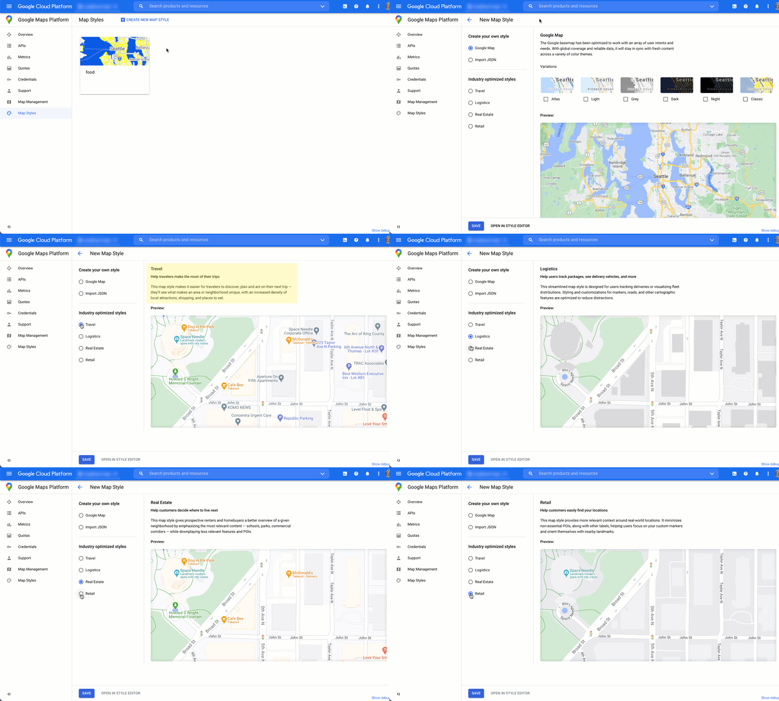
### Industry map styles
This animation shows predefined industry-specific map styles you can
use. These styles provide an optimal starting point for each type of
industry. For example, the Retail map style reduces points of interest
on the map, letting users focus on your locations, as well as the
landmarks to help them get to the closest location as quickly and
confidently as possible.
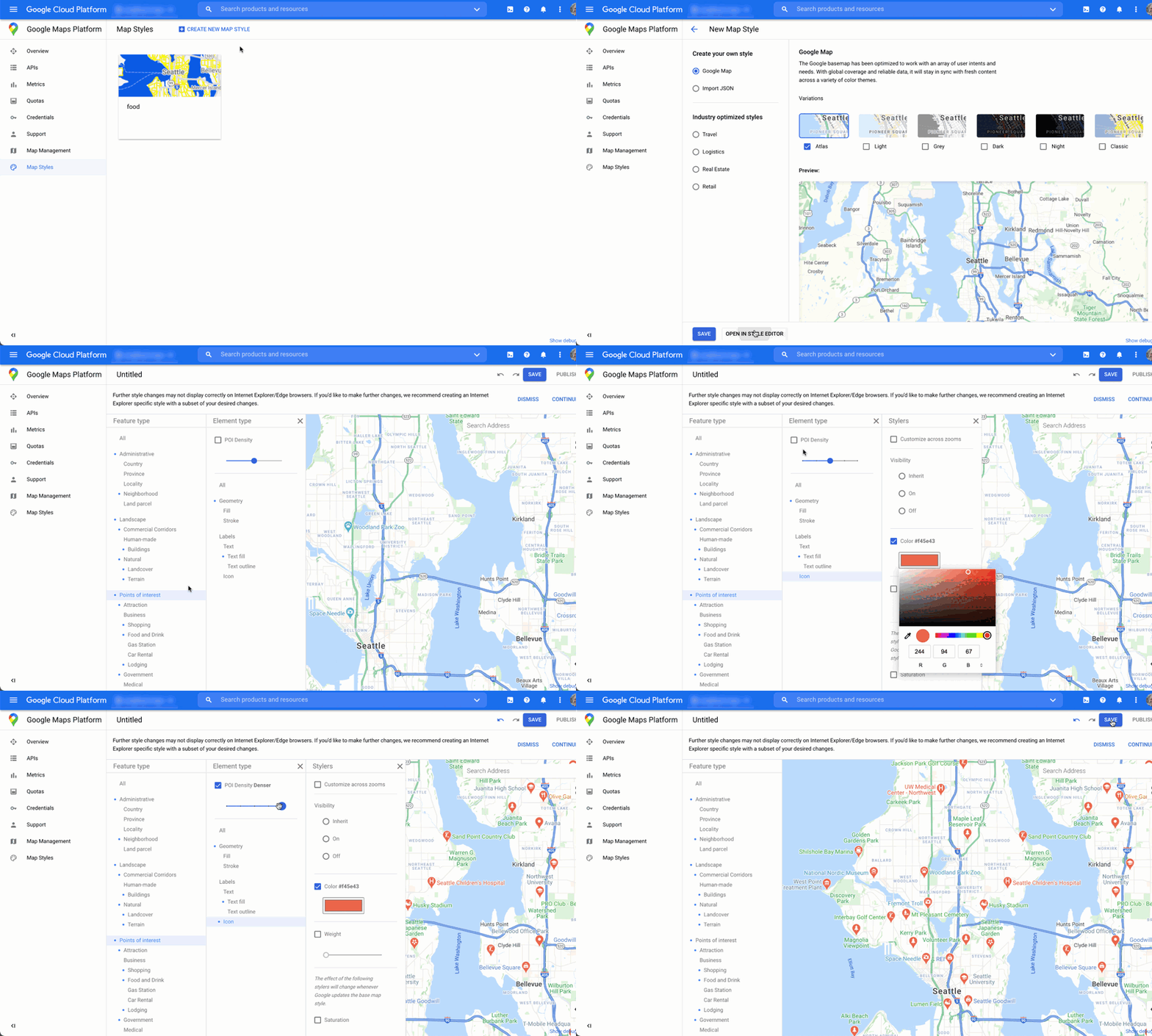
### Points of interest control
This animation sets the marker color for points of interest and
increases the POI density on the map style. The higher the density, the
more POI markers appear on the map.
Each map style has its own ID. After you publish a style in the
Cloud console, you reference that map ID in your code---which
means you can update a map style in real time without refactoring your app. The
new look will automatically appear in the existing application and be used
across platforms. The following examples show how to add a map ID to a web page
using the Maps JavaScript API.
By including one or more `map_ids` in the script URL, the
Maps JavaScript API automatically makes those styles available
for faster map rendering when you call those styles in your code.
```html
```
The following code displays a styled map on the web page. (Not shown is an HTML
`` element where the map will appear
on the page.)
```
map = new google.maps.Map(document.getElementById('map'), {
center: {lat: 51.485925, lng: -0.129500},
zoom: 12,
mapId: '1234abcd5678efgh'
});
```
Learn more about incorporating cloud-based maps styling in
[JavaScript (web)](https://developers.google.com/maps/documentation/javascript/cloud-based-map-styling),
[Android](https://developers.google.com/maps/documentation/android-sdk/cloud-based-map-styling),
and
[iOS](https://developers.google.com/maps/documentation/ios-sdk/cloud-based-map-styling).
## Combine custom location data with Place Details
The previous [Show your locations on an interactive map](https://developers.google.com/maps/architecture/product-locator.md.txt#show_locations)
section describes using Place Details to give users a rich level of
information about your locations, such as opening hours, photos, and reviews.
It's helpful to understand the
[pricing and SKU
tiers of different data fields](https://developers.google.com/maps/documentation/places/web-service/data-fields) in Places API (New). To manage
your costs, one strategy is to combine the information you already have about
your locations with the fresh information from Google Maps such as temporary
closure, holiday hours, and user ratings, photos, and reviews. If you already
have the contact information for your stores, you won't need to request those
fields from Place Details and can constrain your field mask to fetch only the
fields you want to display.
You may have your own place data to supplement or use instead of
Place Details. The
[codelab](https://developers.google.com/codelabs/maps-platform/full-stack-store-locator)
for the full-stack locator provides an example of using GeoJSON with a database
to store and retrieve your own location details.