-
MethaneAIR L4 Area Sources 2021
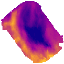
The area emissions model is still in development and not representative of a final product. This dataset provides high-resolution, spatially disaggregated methane emission fluxes (kg/hr) of the Permian Delaware sub-basin in southern New Mexico and western Texas as well as for the Uinta basin in … climate edf emissions ghg methane methaneair -
MethaneAIR L4 Point Sources 2021

This dataset provides high-emitting methane point source detections (kg/hr) over the Permian Delaware sub-basin in southern New Mexico and western Texas as well as for the Uinta basin in Utah. Methane is a potent greenhouse gas that has more than 80 times the warming power … climate edf emissions ghg methane methaneair -
OGIM: Oil and Gas Infrastructure Mapping Database v2.4_RF06_RF08
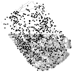
This dataset provides the locations of oil and gas (O&G) related infrastructure within two key O&G producing regions in the United States: the Delaware sub-basin of the Permian Basin in western Texas and southern New Mexico, and the Uinta Basin in Utah. The Oil and … climate edf emissions ghg methane methaneair -
UN FAO Drained Organic Soils Area (Annual) 1.0
The two related FAO datasets on Drained Organic Soils provide estimates of: DROSA-A: area of Organic Soils (in hectares) drained for agricultural activities (cropland and grazed grassland) DROSE-A: carbon (C) and nitrous oxide (N2O) estimates (in gigagrams) from the agricultural drainage of organic soils under … agriculture climate-change emissions fao ghg organic-soils -
Drained Organic Soils Emissions (Annual) 1.0

The two related FAO datasets on Drained Organic Soils provide estimates of: DROSA-A: area of Organic Soils (in hectares) drained for agricultural activities (cropland and grazed grassland) DROSE-A: carbon (C) and nitrous oxide (N2O) estimates (in gigagrams) from the agricultural drainage of organic soils under … agriculture climate-change emissions fao ghg organic-soils
[{
"type": "thumb-down",
"id": "missingTheInformationINeed",
"label":"Missing the information I need"
},{
"type": "thumb-down",
"id": "tooComplicatedTooManySteps",
"label":"Too complicated / too many steps"
},{
"type": "thumb-down",
"id": "outOfDate",
"label":"Out of date"
},{
"type": "thumb-down",
"id": "samplesCodeIssue",
"label":"Samples / code issue"
},{
"type": "thumb-down",
"id": "otherDown",
"label":"Other"
}]
[{
"type": "thumb-up",
"id": "easyToUnderstand",
"label":"Easy to understand"
},{
"type": "thumb-up",
"id": "solvedMyProblem",
"label":"Solved my problem"
},{
"type": "thumb-up",
"id": "otherUp",
"label":"Other"
}]