-
GOES-16 FDCC Series ABI Level 2 Fire/Hot Spot Characterization CONUS
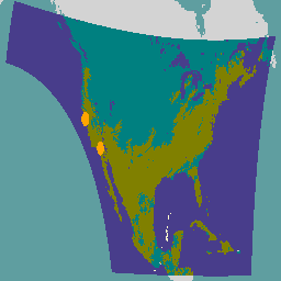
The Fire (HSC) product contains four images: one in the form of a fire mask and the other three with pixel values identifying fire temperature, fire area, and fire radiative power. The ABI L2+ FHS metadata mask assigns a flag to every earth-navigated pixel that … abi climate fdc fire goes goes-16 -
GOES-16 FDCF Series ABI Level 2 Fire/Hot Spot Characterization Full Disk
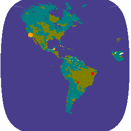
The Fire (HSC) product contains four images: one in the form of a fire mask and the other three with pixel values identifying fire temperature, fire area, and fire radiative power. The ABI L2+ FHS metadata mask assigns a flag to every earth-navigated pixel that … abi climate fdc fire goes goes-16 -
GOES-17 FDCC Series ABI Level 2 Fire/Hot Spot Characterization CONUS
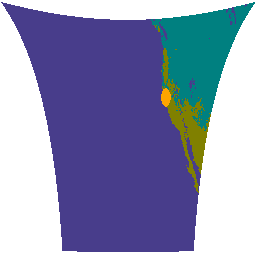
The Fire (HSC) product contains four images: one in the form of a fire mask and the other three with pixel values identifying fire temperature, fire area, and fire radiative power. The ABI L2+ FHS metadata mask assigns a flag to every earth-navigated pixel that … abi climate fdc fire goes goes-17 -
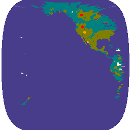
GOES-17 FDCF Series ABI Level 2 Fire/Hot Spot Characterization Full Disk

The Fire (HSC) product contains four images: one in the form of a fire mask and the other three with pixel values identifying fire temperature, fire area, and fire radiative power. The ABI L2+ FHS metadata mask assigns a flag to every earth-navigated pixel that … abi climate fdc fire goes goes-17 -
GOES-18 FDCC Series ABI Level 2 Fire/Hot Spot Characterization CONUS

The Fire (HSC) product contains four images: one in the form of a fire mask and the other three with pixel values identifying fire temperature, fire area, and fire radiative power. The ABI L2+ FHS metadata mask assigns a flag to every earth-navigated pixel that … abi climate fdc fire goes goes-18 -
GOES-18 FDCF Series ABI Level 2 Fire/Hot Spot Characterization Full Disk
The Fire (HSC) product contains four images: one in the form of a fire mask and the other three with pixel values identifying fire temperature, fire area, and fire radiative power. The ABI L2+ FHS metadata mask assigns a flag to every earth-navigated pixel that … abi climate fdc fire goes goes-18
[{
"type": "thumb-down",
"id": "missingTheInformationINeed",
"label":"Missing the information I need"
},{
"type": "thumb-down",
"id": "tooComplicatedTooManySteps",
"label":"Too complicated / too many steps"
},{
"type": "thumb-down",
"id": "outOfDate",
"label":"Out of date"
},{
"type": "thumb-down",
"id": "samplesCodeIssue",
"label":"Samples / code issue"
},{
"type": "thumb-down",
"id": "otherDown",
"label":"Other"
}]
[{
"type": "thumb-up",
"id": "easyToUnderstand",
"label":"Easy to understand"
},{
"type": "thumb-up",
"id": "solvedMyProblem",
"label":"Solved my problem"
},{
"type": "thumb-up",
"id": "otherUp",
"label":"Other"
}]