-
US EPA Ecoregions (Level III)
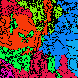
The U.S. Environmental Protection Agency (USEPA) provides the Ecoregions dataset to serve as a spatial framework for the research, assessment, management, and monitoring of ecosystems and ecosystem components. Ecoregions denote areas of general similarity in ecosystems and in the type, quality, and quantity of environmental … ecoregions epa -
US EPA Ecoregions (Level IV)

The U.S. Environmental Protection Agency (USEPA) provides the Ecoregions dataset to serve as a spatial framework for the research, assessment, management, and monitoring of ecosystems and ecosystem components. Ecoregions denote areas of general similarity in ecosystems and in the type, quality, and quantity of environmental … ecoregions epa
[{
"type": "thumb-down",
"id": "missingTheInformationINeed",
"label":"Missing the information I need"
},{
"type": "thumb-down",
"id": "tooComplicatedTooManySteps",
"label":"Too complicated / too many steps"
},{
"type": "thumb-down",
"id": "outOfDate",
"label":"Out of date"
},{
"type": "thumb-down",
"id": "samplesCodeIssue",
"label":"Samples / code issue"
},{
"type": "thumb-down",
"id": "otherDown",
"label":"Other"
}]
[{
"type": "thumb-up",
"id": "easyToUnderstand",
"label":"Easy to understand"
},{
"type": "thumb-up",
"id": "solvedMyProblem",
"label":"Solved my problem"
},{
"type": "thumb-up",
"id": "otherUp",
"label":"Other"
}]