

說明
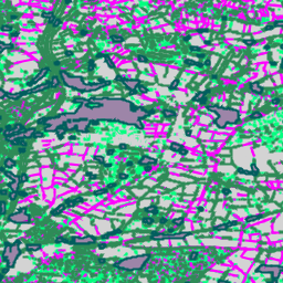
這是 Farmscapes 2020 點陣資料集的向量化版本,提供多邊形幾何圖形,代表英格蘭農業景觀中細微的半自然景觀特徵 (具體來說是樹籬、林地和石牆)。這個資料集是與牛津 Leverhulme 自然復育中心合作開發,可做為景觀復育、生物多樣性監測和生態連通性分析等應用程式的基準。
這項資料是透過向量化高解析度 (25 公分) 的 Farmscapes 2020 年機率地圖得出,並經過篩選排除「樹籬間隙」特徵,以及簡化處理,只保留特徵分類屬性。
限制
- 地理範圍:在人口密集的市區和山區,模型效能會降低,因為訓練資料主要著重於鄉村景觀,這類環境的代表性不足。
- 時間準確度:來源圖像的拍攝時間介於 2018 年至 2020 年。 因此,資料集不會計入這段期間之後發生的環境變化。
- 特定類別的效能:與林地和樹籬相比,石牆類別的準確度較低,這是因為訓練資料中存在顯著的類別不平衡問題。
資料表結構定義
資料表結構定義
| 名稱 | 類型 | 說明 |
|---|---|---|
| feature_name | STRING | 地景特徵類型:「樹籬」、「樹叢」、「線狀林地」、「石牆」或「林地」。 |
使用條款
使用條款
這個資料集採用 CC BY 4.0 授權,並須註明出處:「這個資料集由 Google 製作」。
參考資料
參考資料:
Michelangelo Conserva、Alex Wilson、Charlotte Stanton、Vishal Batchu、Varun Gulshan,「Mapping Farmed Landscapes from Remote Sensing」(審查中)。doi:10.48550/arXiv.2506.13993
使用 Earth Engine 探索
程式碼編輯器 (JavaScript)
var fc = ee.FeatureCollection('projects/nature-trace/assets/farmscapes/england_v1_0_vectorised');

var styles = {
  'hedgerow': {color: 'FF00FF', fillColor: '40FF00FF'},
  'copse': {color: '00FF7F', fillColor: '4000FF7F'},
  'linear_woodland': {color: '2E8B57', fillColor: '402E8B57'},
  'stone wall': {color: 'D3D3D3', fillColor: '40D3D3D3'},
  'woodland': {color: '005e5e', fillColor: '40005e5e'},
};

var styleDict = ee.Dictionary(styles);

var styledFc = fc.map(function(f) {
  var featureStyle = ee.Dictionary(styleDict.get(f.get('feature_name')));
  return f.set('style', featureStyle);
});

var styledImage = styledFc.style({
  styleProperty: 'style', width: 2
});

Map.addLayer(styledImage, {}, 'Farmscapes Vectors');

var legend = ui.Panel({
  style: {
    position: 'top-left',
    padding: '8px 15px',
    backgroundColor: 'rgba(255, 255, 255, 0.9)',
    border: '1px solid black'
  }
});

legend.add(ui.Label({
  value: 'Farmscapes Vectors',
  style: {fontWeight: 'bold', fontSize: '16px', margin: '0 0 4px 0', padding: '0'}
}));

var palette = [
  {color: 'FF00FF', name: 'Hedgerow'},
  {color: '00FF7F', name: 'Copse'},
  {color: '2E8B57', name: 'Linear Woodland'},
  {color: 'D3D3D3', name: 'Stone Wall'},
  {color: '005e5e', name: 'Woodland'},
];

palette.forEach(function(item) {
  var colorBox = ui.Label({
    style: {backgroundColor: '#' + item.color, padding: '8px', margin: '0 0 4px 0'}
  });
  var desc = ui.Label({value: item.name, style: {margin: '0 0 4px 6px'}});
  legend.add(ui.Panel({
    widgets: [colorBox, desc],
    layout: ui.Panel.Layout.Flow('horizontal')
  }));
});

Map.add(legend);

var lon = -1.43;
var lat = 52.973;
Map.setCenter(lon, lat, 15);
以 FeatureView 形式呈現
FeatureView 是 FeatureCollection 的加速表示法,只能用來檢視。詳情請參閱
FeatureView 說明文件。
程式碼編輯器 (JavaScript)
var fv = ui.Map.FeatureViewLayer(
    'projects/nature-trace/assets/farmscapes/england_v1_0_vectorised_FeatureView');

fv.setVisParams({
  lineWidth: 2,
  color: '808080',
  polygonFillOpacity: 0.25,
  rules: [
    {
      filter: ee.Filter.eq('feature_name', 'hedgerow'),
      color: 'FF00FF',
      polygonFillColor: 'FF00FF'
    },
    {
      filter: ee.Filter.eq('feature_name', 'copse'),
      color: '00FF7F',
      polygonFillColor: '00FF7F'
    },
    {
      filter: ee.Filter.eq('feature_name', 'linear_woodland'),
      color: '2E8B57',
      polygonFillColor: '2E8B57'
    },
    {
      filter: ee.Filter.eq('feature_name', 'stone wall'),
      color: 'D3D3D3',
      polygonFillColor: 'D3D3D3'
    },
    {
      filter: ee.Filter.eq('feature_name', 'woodland'),
      color: '005e5e',
      polygonFillColor: '005e5e'
    }
  ]
});
fv.setName('Farmscapes Vectors');
Map.add(fv);

var legend = ui.Panel({
  style: {
    position: 'top-left',
    padding: '8px 15px',
    backgroundColor: 'rgba(255, 255, 255, 0.9)',
    border: '1px solid black'
  }
});
legend.add(ui.Label({
  value: 'Farmscapes Vectors',
  style:
      {fontWeight: 'bold', fontSize: '16px', margin: '0 0 4px 0', padding: '0'}
}));

var palette = [
  {color: 'FF00FF', name: 'Hedgerow'}, {color: '00FF7F', name: 'Copse'},
  {color: '2E8B57', name: 'Linear Woodland'},
  {color: 'D3D3D3', name: 'Stone Wall'}, {color: '005e5e', name: 'Woodland'},
];

palette.forEach(function(item) {
  var colorBox = ui.Label({
    style:
        {backgroundColor: '#' + item.color, padding: '8px', margin: '0 0 4px 0'}
  });
  var desc = ui.Label({value: item.name, style: {margin: '0 0 4px 6px'}});
  legend.add(ui.Panel(
      {widgets: [colorBox, desc], layout: ui.Panel.Layout.Flow('horizontal')}));
});

Map.add(legend);

var lon = -1.43;
var lat = 52.973;
Map.setCenter(lon, lat, 15);