

- เจ้าของแคตตาล็อก
- Nature Trace
- ความพร้อมใช้งานของชุดข้อมูล
- 2018-01-01T00:00:00Z–2020-12-31T23:59:59Z
- ผู้ผลิตชุดข้อมูล
- แท็ก
คำอธิบาย
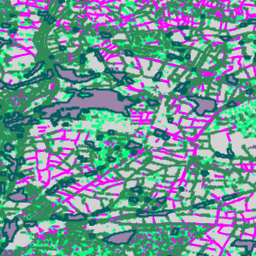
นี่คือเวอร์ชันเวกเตอร์ของชุดข้อมูลแรสเตอร์ Farmscapes 2020 โดยมีรูปทรงเรขาคณิตแบบรูปหลายเหลี่ยมที่แสดงถึงลักษณะภูมิทัศน์กึ่งธรรมชาติขนาดเล็ก (โดยเฉพาะรั้วต้นไม้ ป่าไม้ และกำแพงหิน) ทั่วภูมิทัศน์เกษตรกรรมของอังกฤษ ชุดข้อมูลนี้ได้รับการพัฒนาโดยความร่วมมือกับ Oxford Leverhulme Centre for Nature Recovery เพื่อใช้เป็นพื้นฐานสำหรับการใช้งานต่างๆ รวมถึงการฟื้นฟูภูมิทัศน์ การตรวจสอบความหลากหลายทางชีวภาพ และการวิเคราะห์การเชื่อมต่อทางระบบนิเวศ
โดยได้มาจากการแปลงแผนที่ความน่าจะเป็นของ Farmscapes 2020 ความละเอียดสูง (25 ซม.) เป็นเวกเตอร์ กรองเพื่อยกเว้นฟีเจอร์ "ช่องว่างของพุ่มไม้" และลดความซับซ้อน เพื่อเก็บเฉพาะแอตทริบิวต์การจัดประเภทฟีเจอร์
ข้อจำกัด
- ขอบเขตทางภูมิศาสตร์: ประสิทธิภาพของโมเดลลดลงในสภาพแวดล้อมในเมืองที่มีประชากรหนาแน่นและพื้นที่ภูเขา ซึ่งเป็นพื้นที่ที่แสดงในข้อมูลฝึกฝนน้อยกว่าปกติซึ่งมุ่งเน้นที่ภูมิทัศน์ในชนบทเป็นหลัก
- ความถูกต้องตามเวลา: ภาพจากแหล่งที่มาถ่ายระหว่างปี 2018 ถึง 2020 ดังนั้น ชุดข้อมูลจึงไม่ได้คำนึงถึงการเปลี่ยนแปลงของภูมิทัศน์ที่เกิดขึ้นตั้งแต่ช่วงเวลานี้
- ประสิทธิภาพเฉพาะคลาส: คลาสกำแพงหินมีความแม่นยำต่ำกว่า เมื่อเทียบกับป่าไม้และพุ่มไม้ ซึ่งเป็นผลมาจาก ความไม่สมดุลของคลาสอย่างมากในข้อมูลการฝึก
สคีมาของตาราง
สคีมาของตาราง
| ชื่อ | ประเภท | คำอธิบาย |
|---|---|---|
| feature_name | STRING | ประเภทของฟีเจอร์ภูมิประเทศ: "hedgerow", "copse", "linear_woodland", "stone wall" หรือ "woodland" |
ข้อกำหนดในการใช้งาน
ข้อกำหนดในการใช้งาน
ชุดข้อมูลนี้ได้รับอนุญาตภายใต้ CC-BY 4.0 และต้องมีการระบุแหล่งที่มาดังนี้ "ชุดข้อมูลนี้จัดทำโดย Google"
การอ้างอิง
Michelangelo Conserva, Alex Wilson, Charlotte Stanton, Vishal Batchu, Varun Gulshan , "Mapping Farmed Landscapes from Remote Sensing" (อยู่ระหว่างตรวจสอบ) doi:10.48550/arXiv.2506.13993,
สำรวจด้วย Earth Engine
ตัวแก้ไขโค้ด (JavaScript)
var fc = ee.FeatureCollection('projects/nature-trace/assets/farmscapes/england_v1_0_vectorised');

var styles = {
  'hedgerow': {color: 'FF00FF', fillColor: '40FF00FF'},
  'copse': {color: '00FF7F', fillColor: '4000FF7F'},
  'linear_woodland': {color: '2E8B57', fillColor: '402E8B57'},
  'stone wall': {color: 'D3D3D3', fillColor: '40D3D3D3'},
  'woodland': {color: '005e5e', fillColor: '40005e5e'},
};

var styleDict = ee.Dictionary(styles);

var styledFc = fc.map(function(f) {
  var featureStyle = ee.Dictionary(styleDict.get(f.get('feature_name')));
  return f.set('style', featureStyle);
});

var styledImage = styledFc.style({
  styleProperty: 'style', width: 2
});

Map.addLayer(styledImage, {}, 'Farmscapes Vectors');

var legend = ui.Panel({
  style: {
    position: 'top-left',
    padding: '8px 15px',
    backgroundColor: 'rgba(255, 255, 255, 0.9)',
    border: '1px solid black'
  }
});

legend.add(ui.Label({
  value: 'Farmscapes Vectors',
  style: {fontWeight: 'bold', fontSize: '16px', margin: '0 0 4px 0', padding: '0'}
}));

var palette = [
  {color: 'FF00FF', name: 'Hedgerow'},
  {color: '00FF7F', name: 'Copse'},
  {color: '2E8B57', name: 'Linear Woodland'},
  {color: 'D3D3D3', name: 'Stone Wall'},
  {color: '005e5e', name: 'Woodland'},
];

palette.forEach(function(item) {
  var colorBox = ui.Label({
    style: {backgroundColor: '#' + item.color, padding: '8px', margin: '0 0 4px 0'}
  });
  var desc = ui.Label({value: item.name, style: {margin: '0 0 4px 6px'}});
  legend.add(ui.Panel({
    widgets: [colorBox, desc],
    layout: ui.Panel.Layout.Flow('horizontal')
  }));
});

Map.add(legend);

var lon = -1.43;
var lat = 52.973;
Map.setCenter(lon, lat, 15);
แสดงภาพเป็น FeatureView
FeatureView คือการแสดงFeatureCollectionแบบเร่งความเร็วที่ดูได้อย่างเดียว ดูรายละเอียดเพิ่มเติมได้ที่เอกสารประกอบของ
FeatureView
ตัวแก้ไขโค้ด (JavaScript)
var fv = ui.Map.FeatureViewLayer(
    'projects/nature-trace/assets/farmscapes/england_v1_0_vectorised_FeatureView');

fv.setVisParams({
  lineWidth: 2,
  color: '808080',
  polygonFillOpacity: 0.25,
  rules: [
    {
      filter: ee.Filter.eq('feature_name', 'hedgerow'),
      color: 'FF00FF',
      polygonFillColor: 'FF00FF'
    },
    {
      filter: ee.Filter.eq('feature_name', 'copse'),
      color: '00FF7F',
      polygonFillColor: '00FF7F'
    },
    {
      filter: ee.Filter.eq('feature_name', 'linear_woodland'),
      color: '2E8B57',
      polygonFillColor: '2E8B57'
    },
    {
      filter: ee.Filter.eq('feature_name', 'stone wall'),
      color: 'D3D3D3',
      polygonFillColor: 'D3D3D3'
    },
    {
      filter: ee.Filter.eq('feature_name', 'woodland'),
      color: '005e5e',
      polygonFillColor: '005e5e'
    }
  ]
});
fv.setName('Farmscapes Vectors');
Map.add(fv);

var legend = ui.Panel({
  style: {
    position: 'top-left',
    padding: '8px 15px',
    backgroundColor: 'rgba(255, 255, 255, 0.9)',
    border: '1px solid black'
  }
});
legend.add(ui.Label({
  value: 'Farmscapes Vectors',
  style:
      {fontWeight: 'bold', fontSize: '16px', margin: '0 0 4px 0', padding: '0'}
}));

var palette = [
  {color: 'FF00FF', name: 'Hedgerow'}, {color: '00FF7F', name: 'Copse'},
  {color: '2E8B57', name: 'Linear Woodland'},
  {color: 'D3D3D3', name: 'Stone Wall'}, {color: '005e5e', name: 'Woodland'},
];

palette.forEach(function(item) {
  var colorBox = ui.Label({
    style:
        {backgroundColor: '#' + item.color, padding: '8px', margin: '0 0 4px 0'}
  });
  var desc = ui.Label({value: item.name, style: {margin: '0 0 4px 6px'}});
  legend.add(ui.Panel(
      {widgets: [colorBox, desc], layout: ui.Panel.Layout.Flow('horizontal')}));
});

Map.add(legend);

var lon = -1.43;
var lat = 52.973;
Map.setCenter(lon, lat, 15);