

- בעלי הקטלוג
- Nature Trace
- זמינות קבוצת הנתונים
- 2018-01-01T00:00:00Z–2020-12-31T23:59:59Z
- מפיק מערך הנתונים
- תגים
תיאור
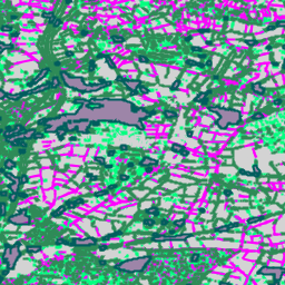
זוהי הגרסה הווקטורית של קבוצת נתוני הרסטר Farmscapes 2020. הוא מספק גיאומטריות של פוליגונים שמייצגות מאפיינים של נוף טבעי למחצה בקנה מידה קטן (במיוחד גדרות חיות, יערות וקירות אבן) בנופים החקלאיים של אנגליה. קבוצת הנתונים הזו פותחה בשיתוף עם Oxford Leverhulme Centre for Nature Recovery כדי לשמש כבסיס לאפליקציות שכוללות שיקום נוף, ניטור מגוון ביולוגי וניתוח של קישוריות אקולוגית.
הוא נגזר מוקטוריזציה של מפות ההסתברות של Farmscapes 2020 ברזולוציה גבוהה (25 ס"מ), מסונן כדי לא לכלול תכונות של 'פערים בגידור', ומפושט כדי לשמור רק על מאפיין סיווג התכונות.
מגבלות
- היקף גיאוגרפי: הביצועים של המודל יורדים בסביבות עירוניות צפופות ובאזורים הרריים, שלא יוצגו מספיק בנתוני האימון שהתמקדו בעיקר בנופים כפריים.
- דיוק זמני: תמונות המקור צולמו בין 2018 ל-2020. לכן, מערך הנתונים לא כולל שינויים במצב השוק שקרו מאז התקופה הזו.
- ביצועים ספציפיים לכיתה: הכיתה של קיר האבן מציגה דיוק נמוך יותר בהשוואה לכיתות של יערות וגדרות חיות, כתוצאה מחוסר איזון משמעותי בין הכיתות בנתוני האימון.
סכימת טבלה
סכימת טבלה
| שם | סוג | תיאור |
|---|---|---|
| feature_name | מחרוזת | סוג התכונה של הנוף: hedgerow (גדר חיה), copse (חורשה), linear_woodland (שטח מיוער ליניארי), stone wall (קיר אבן) או woodland (שטח מיוער). |
תנאים והגבלות
תנאים והגבלות
מערך הנתונים הזה מותר לשימוש במסגרת רישיון CC-BY 4.0, ונדרש שיוך מהסוג הבא: "מערך הנתונים הזה נוצר על ידי Google".
ציטוטים ביבליוגרפיים
מיכלאנג'לו קונסרבה (Michelangelo Conserva), אלכס וילסון (Alex Wilson), שרלוט סטנטון (Charlotte Stanton), וישאל באטצ'ו (Vishal Batchu), וארון גולשאן (Varun Gulshan), "מיפוי נופים חקלאיים מחישה מרחוק" (בבדיקה). doi:10.48550/arXiv.2506.13993,
סיור עם פלטפורמת Earth Engine
עורך קוד (JavaScript)
var fc = ee.FeatureCollection('projects/nature-trace/assets/farmscapes/england_v1_0_vectorised');

var styles = {
  'hedgerow': {color: 'FF00FF', fillColor: '40FF00FF'},
  'copse': {color: '00FF7F', fillColor: '4000FF7F'},
  'linear_woodland': {color: '2E8B57', fillColor: '402E8B57'},
  'stone wall': {color: 'D3D3D3', fillColor: '40D3D3D3'},
  'woodland': {color: '005e5e', fillColor: '40005e5e'},
};

var styleDict = ee.Dictionary(styles);

var styledFc = fc.map(function(f) {
  var featureStyle = ee.Dictionary(styleDict.get(f.get('feature_name')));
  return f.set('style', featureStyle);
});

var styledImage = styledFc.style({
  styleProperty: 'style', width: 2
});

Map.addLayer(styledImage, {}, 'Farmscapes Vectors');

var legend = ui.Panel({
  style: {
    position: 'top-left',
    padding: '8px 15px',
    backgroundColor: 'rgba(255, 255, 255, 0.9)',
    border: '1px solid black'
  }
});

legend.add(ui.Label({
  value: 'Farmscapes Vectors',
  style: {fontWeight: 'bold', fontSize: '16px', margin: '0 0 4px 0', padding: '0'}
}));

var palette = [
  {color: 'FF00FF', name: 'Hedgerow'},
  {color: '00FF7F', name: 'Copse'},
  {color: '2E8B57', name: 'Linear Woodland'},
  {color: 'D3D3D3', name: 'Stone Wall'},
  {color: '005e5e', name: 'Woodland'},
];

palette.forEach(function(item) {
  var colorBox = ui.Label({
    style: {backgroundColor: '#' + item.color, padding: '8px', margin: '0 0 4px 0'}
  });
  var desc = ui.Label({value: item.name, style: {margin: '0 0 4px 6px'}});
  legend.add(ui.Panel({
    widgets: [colorBox, desc],
    layout: ui.Panel.Layout.Flow('horizontal')
  }));
});

Map.add(legend);

var lon = -1.43;
var lat = 52.973;
Map.setCenter(lon, lat, 15);
ויזואליזציה כ-FeatureView
FeatureView הוא ייצוג מואץ של FeatureCollection לצפייה בלבד. פרטים נוספים ניתן לקרוא ב
מסמכי התיעוד של FeatureView.
Code Editor (JavaScript)
var fv = ui.Map.FeatureViewLayer(
    'projects/nature-trace/assets/farmscapes/england_v1_0_vectorised_FeatureView');

fv.setVisParams({
  lineWidth: 2,
  color: '808080',
  polygonFillOpacity: 0.25,
  rules: [
    {
      filter: ee.Filter.eq('feature_name', 'hedgerow'),
      color: 'FF00FF',
      polygonFillColor: 'FF00FF'
    },
    {
      filter: ee.Filter.eq('feature_name', 'copse'),
      color: '00FF7F',
      polygonFillColor: '00FF7F'
    },
    {
      filter: ee.Filter.eq('feature_name', 'linear_woodland'),
      color: '2E8B57',
      polygonFillColor: '2E8B57'
    },
    {
      filter: ee.Filter.eq('feature_name', 'stone wall'),
      color: 'D3D3D3',
      polygonFillColor: 'D3D3D3'
    },
    {
      filter: ee.Filter.eq('feature_name', 'woodland'),
      color: '005e5e',
      polygonFillColor: '005e5e'
    }
  ]
});
fv.setName('Farmscapes Vectors');
Map.add(fv);

var legend = ui.Panel({
  style: {
    position: 'top-left',
    padding: '8px 15px',
    backgroundColor: 'rgba(255, 255, 255, 0.9)',
    border: '1px solid black'
  }
});
legend.add(ui.Label({
  value: 'Farmscapes Vectors',
  style:
      {fontWeight: 'bold', fontSize: '16px', margin: '0 0 4px 0', padding: '0'}
}));

var palette = [
  {color: 'FF00FF', name: 'Hedgerow'}, {color: '00FF7F', name: 'Copse'},
  {color: '2E8B57', name: 'Linear Woodland'},
  {color: 'D3D3D3', name: 'Stone Wall'}, {color: '005e5e', name: 'Woodland'},
];

palette.forEach(function(item) {
  var colorBox = ui.Label({
    style:
        {backgroundColor: '#' + item.color, padding: '8px', margin: '0 0 4px 0'}
  });
  var desc = ui.Label({value: item.name, style: {margin: '0 0 4px 6px'}});
  legend.add(ui.Panel(
      {widgets: [colorBox, desc], layout: ui.Panel.Layout.Flow('horizontal')}));
});

Map.add(legend);

var lon = -1.43;
var lat = 52.973;
Map.setCenter(lon, lat, 15);