 info
This dataset is part of a Publisher Catalog, and not managed by Google Earth Engine.
Contact [EDF-MethaneSAT](https://www.methanesat.org/contact)
for bugs or [view more datasets](https://developers.google.com/earth-engine/datasets/publisher/edf-methanesat-ee.md.txt)
from the Environmental Defense Fund - MethaneSAT Catalog. [Learn more about Publisher datasets](https://developers.google.com/earth-engine/datasets/publisher).
[](https://www.methanesat.org/data)
Catalog Owner
: Environmental Defense Fund - MethaneSAT
Dataset Availability
: 2024-05-01T00:00:00Z--2025-06-20T00:00:00Z
Dataset Producer
:
[Environmental Defense Fund - MethaneSAT](https://methanesat.org)
Contact
: [EDF-MethaneSAT](https://www.methanesat.org/contact)
Tags
:
atmosphere climate edf edf-methanesat-ee emissions ghg methane methanesat publisher-dataset
#### Description
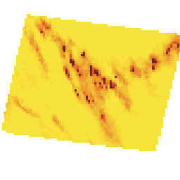
This dataset provides the most recently processed data for methane emissions on an
approximately 4 km x 4 km grid. These data include total methane emissions and their spatial
distribution at high resolution to meet global methane mitigation goals.
These methane emissions estimates were made using the Column Observations to Regional
Emissions (CORE) algorithm. The primary input to CORE is methane concentration observations
in the form of column-averaged dry-air mole fractions of methane (XCH4). An atmospheric
transport model; the Stochastic Time-Inverted Lagrangian Transport (STILT) model;
[Lin et al. (2003)](https://doi.org/10.1029/2002JD003161),
[Fasoli et al. (2018)](https://doi.org/10.5194/gmd-11-2813-2018);
driven by meteorological data from the National Centers for Environmental Prediction
([NCEP](https://www.weather.gov/ncep/)) Global Forecast System
([GFS](https://www.emc.ncep.noaa.gov/emc/pages/numerical_forecast_systems/gfs.php));
links variations in observed
XCH4 to potential upwind sources. Emissions and inflow across the upwind boundary are
inferred with a Bayesian inverse model using Hamiltonian Monte Carlo (HMC) sampling
implemented in the Stan probabilistic programming framework
([Carpenter et al., 2017](https://www.jstatsoft.org/article/view/v076i01)). The
CORE algorithm will continue to be updated as the team improves the methodology. Any
significant changes in methodology will be documented through updates to the MethaneSAT
Level-4 Dispersed Emissions Product
[Algorithm Theoretical Basis Document](https://zenodo.org/records/20030295) (ATBD).
These observations made by MethaneSAT are broadly consistent with independent empirical
data where available from other sources. Not all data products (L3 concentration, L4 area and
L4 point) are available for all collection IDs. Individual heat maps can have spatial misallocations
due to several factors, including wind field uncertainty, observational uncertainty and variable
emission rates. Users are advised to interpret individual emission grids with caution. For more
about definitions and limitations, see our
[technical explanation](https://www.methanesat.org/sites/default/files/2026-07/MethaneSAT%20Dispersed%20Area%20Emissions%20Definitions%20and%20Limitations.pdf).
To learn more about MethaneSAT algorithm versions, see this [overview](https://www.methanesat.org/sites/default/files/2026-07/Overview%20of%20MethaneSAT%20Algorithm%20Versions.pdf).
Contact the data provider for more information about the project at this link:
.
*** ** * ** ***
7/2/2025 Important Update:
> [!NOTE]
> **Note:** The satellite lost contact with the ground in June of 2025: [MethaneSAT Loses Contact with Satellite \| MethaneSAT](https://www.methanesat.org/project-updates/methanesat-loses-contact-satellite). Existing datasets will remain accessible on Google platforms and on our web portal for the foreseeable future. They have been reprocessed using greatly improved algorithms and released in August, 2026. The reprocessed data are superior in all respects compared to our interim releases earlier in 2026, and additional scenes have been added that were not available previously. These datasets should be used for future analysis in preference to previous releases, which are deprecated.
To stay up to date with further updates, please sign up for our
[newsletter](https://mailchi.mp/methanesat/methanesat-newsletter-sign-up). For additional
information about the data products, algorithms, or calibration, view the publications on our
[website](https://www.methanesat.org/scienceandresearch).
### Bands
**Bands**
Pixel size: 4000 meters (all bands)
| Name | Units | Min | Max | Pixel Size | Description |
|---|---|---|---|---|---|
| `mean_flux` | kg/h | 0\* | 15000\* | 4000 meters | Methane emissions traceable to a 4km\^2 area. |
| `lower_bound_flux` | kg/h | 0\* | 15000\* | 4000 meters | Lower bound on the 95% confidence interval of flux. |
| `upper_bound_flux` | kg/h | 0\* | 15000\* | 4000 meters | Upper bound on the 95% confidence interval of flux. |
\* estimated min or max value
### Image Properties
**Image Properties**
| Name | Type | Description |
|---|---|---|
| mean_total_flux_kg_hr | DOUBLE | Total value of area emissions for this collection. Missing values are indicated by -1. |
| total_flux_lower_bound_kg_hr | DOUBLE | Lower bound on the 95% confidence interval of the total value of area emissions for this collection. |
| total_flux_upper_bound_kg_hr | DOUBLE | Upper bound on the 95% confidence interval of the total value of area emissions for this collection. |
| target_mean_total_kg_hr | DOUBLE | Total value of area emissions in the target for this collection. Missing values are indicated by -1. |
| target_total_flux_lower_bound_kg_hr | DOUBLE | Lower bound on the 95% confidence interval of the total value of area emissions in the target for this collection. |
| target_total_flux_upper_bound_kg_hr | DOUBLE | Upper bound on the 95% confidence interval of the total value of area emissions in the target for this collection. |
| flux_noise_floor_kg_hr | DOUBLE | Below this value, we believe fluxes are indistinguishable from 0. |
| collection_id | STRING | Satellite observation number. |
| processing_id | STRING | (internal) Processing run identifier that represents the calculations that led to the features. It is not an attribute describing the flight, but the processing pipeline. |
| target_id | INT | Satellite Target ID. |
| time_coverage_end | STRING | Data collection end time in YYYY-MM-DDThh:mm:ssZ format STRING (ISO 8601). |
| time_coverage_start | STRING | Data collection start time in YYYY-MM-DDThh:mm:ssZ format STRING (ISO 8601). |
### Terms of Use
**Terms of Use**
Use of this data is subject to [MethaneSAT's Content License Terms of Use](https://www.methanesat.org/sites/default/files/2025-02/MethaneSAT%20-%20Content%20License%20Terms%20of%20Use%20%28Revised%202-12-2025%29%5B25%5D.pdf).
YOUR LICENSE TO ACCESS THE DATA
- We hereby grant you a limited, nonexclusive, nonassignable, nontransferable, revocable license to use, reproduce, publish, make derivative works, display and perform publicly any Data first made available through the Platform pursuant to the terms set forth herein, subject to your agreement to, compliance with and satisfaction of these Terms of Use (the "License")
- You agree to and acknowledge the following restrictions relating to the License:
- (1) To access the Data, you must complete this [Request Form](https://docs.google.com/forms/d/e/1FAIpQLSdzJDwpTs99tMT5bGk0gep10_UEHi64kGtJWat1FrP8ZjwQcA/viewform), which will ask for your contact information, intended use cases, target customers, and other details that will assist MethaneSAT's understanding of how the Data is being used by you, and, upon submission of such form, MethaneSAT may (in its sole discretion) grant you access to the Data;
- (2) With respect to certain aspects of the Data as described herein, you may use methane concentrations, in parts per billion or any other unit of concentration ("Level 3 Data" or "L3 Data") and methane emission fluxes, in kilograms per hour ("Level 4 Data" or "L4 Data") for:
- (i) internal business evaluation and testing,
- (ii) commercial applications, such as developing and selling derivative products and services that incorporate or are informed by the L3 Data or L4 Data,
- (iii) distribution of the Data made available herein to wholly controlled affiliates of which you will be responsible and liable on their behalf for adherence to these Terms of Use, or
- (iv) methane mitigation activities, including both commercial and non-commercial initiatives;
- (3) You are strictly prohibited from using L3 Data to calculate or derive L4 Data or any similar outputs, except and exclusively for internal use purposes and not to distribute to any third party;
- (4) You may not distribute, publish, sublicense, sell, or otherwise provide L3 Data or L4 Data in its raw form to any third parties, provided, however, that you may develop, commercialize, and sell derivative products and services based on your review of the L3 Data and L4 Data, provided, further (and for the avoidance of doubt), that the underlying L3 Data and L4 Data (in its raw form) shall not be shared nor made directly accessible to end users/third parties; and
- (5) That you are not permitted to distribute the Data on any other platform that would make the Data available to third parties, other than to you and your wholly controlled affiliates.
- As a condition of accessing the Data, you further agree and acknowledge that:
- (1) MethaneSAT seeks information about how the Data will be used and, as such, you shall use best efforts, upon request by MethaneSAT, that you will
- (i) provide feedback on the quality of the Data and any proposed improvements thereto, and
- (ii) share anonymized insights on target customers and market applications;
- (2) MethaneSAT may use aggregated or anonymized insights to refine its Data offerings.
ATTRIBUTION
If you share or use the Data in any manner with any third parties, you must:
- Explicitly state to these third parties that they are agreeing to be bound by the Terms of Use;
- Display a citation that states: "Data from MethaneSAT" and "Download the most current dataset at Google Earth Engine and/or Google Cloud"; and
- Explicitly state to these third parties that, if such third party creates a further project containing the Data, any such users of that project must also agree to be bound by these Terms of Use.
### Citations
Citations:
- Chulakadabba, A., Sargent, M., Lauvaux, T., Benmergui, J. S., Franklin, J.
E., Chan Miller, C., Wilzewski, J. S., Roche, S., Conway, E., Souri, A. H.,
Sun, K., Luo, B., Hawthrone, J., Samra, J., Daube, B. C., Liu, X., Chance,
K., Li, Y., Gautam, R., Omara, M., Rutherford, J. S., Sherwin, E. D.,
Brandt, A., and Wofsy, S. C. 2023. Methane point source quantification using
MethaneAIR: a new airborne imaging spectrometer, Atmos. Meas. Tech., 16,
5771-5785.
[doi:10.5194/amt-16-5771-2023](https://doi.org/10.5194/amt-16-5771-2023)
- Lin, J. C., Gerbig, C., Wofsy, S. C., Andrews, A. E., Daube, B. C.,
Davis, K. J., and Grainger, C. A. 2003. A near-field tool for simulating
the upstream influence of atmospheric observations: The Stochastic
Time-Inverted Lagrangian Transport (STILT) model, J. Geophys. Res.,
108(D16), ACH 2-1-ACH 2-17.
[doi:10.1029/2002JD003161](https://doi.org/10.1029/2002JD003161)
- Fasoli, B., Lin, J. C., Bowling, D. R., Mitchell, L., and Mendoza, D.
2018. Simulating atmospheric tracer concentrations for spatially
distributed receptors: updates to the Stochastic Time-Inverted
Lagrangian Transport model's R interface (STILT-R version 2), Geosci.
Model Dev., 11, 2813-2824.
[doi:10.5194/gmd-11-2813-2018](https://doi.org/10.5194/gmd-11-2813-2018)
- Carpenter, B., Gelman, A., Hoffman, M. D., Lee, D., Goodrich, B.,
Betancourt, M., Brubaker, M., Guo, J., Li, P., and Riddell, A. 2017.
Stan: A Probabilistic Programming Language, Journal of Statistical
Software, 76(1), 1-32.
[doi:10.18637/jss.v076.i01](https://doi.org/10.18637/jss.v076.i01)
### DOIs
-
-
-
### Explore with Earth Engine
> [!NOTE]
> **Important:** Earth Engine is a platform for petabyte-scale scientific analysis and visualization of geospatial datasets, both for public benefit and for business and government users. Earth Engine is free to use for research, education, and nonprofit use. To get started, please [register for Earth Engine access.](https://console.cloud.google.com/earth-engine)
### Code Editor (JavaScript)
```javascript
// Request access to this data by filling out the form at: https://forms.gle/jqw4Mvr63dsV1fUF8
var dataset = ee.ImageCollection("projects/edf-methanesat-ee/assets/msat/L4area")
.filterDate('2024-11-01', '2025-05-01')
.select("mean_flux");
// Visualization
var colorRange = [
"#F9ED3B", "#F7E33A", "#F5D838", "#F1C335", "#EEB934", "#ECAE32","#EB9E2F",
"#EA8D2C", "#EC8129", "#F16823", "#D85627", "#BF442C", "#983623", "#70281A"
];
var fluxVisParams = {
bands: ['mean_flux'],
min: 1,
max: 14,
palette: colorRange,
};
// By default, Earth Engine will use the colors provided in the 'palette' param above
// to define a "color ramp" or gradient. Each color in the 'palette' is mapped to a value evenly
// distributed between 'min' and 'max'. For intermediate values, Earth Engine maps the values
// linearly to a color in between, creating a gradient effect.
// This function forces pixel colors to be one of the 14 colors listed above in colorRange rather
// than using additional in between colors when a gradient is applied.
var prepColorPalette = function(image) {
var img0000 = image.gte(0);
var img0025 = image.gte(4);
var img0050 = image.gte(8);
var img0090 = image.gte(14.4);
var img0150 = image.gte(24);
var img0225 = image.gte(36);
var img0325 = image.gte(52);
var img0450 = image.gte(72);
var img0600 = image.gte(96);
var img0775 = image.gte(124);
var img0975 = image.gte(156);
var img1200 = image.gte(192);
var img1450 = image.gte(232);
var img1700 = image.gte(272);
return img0000
.add(img0025)
.add(img0050)
.add(img0090)
.add(img0150)
.add(img0225)
.add(img0325)
.add(img0450)
.add(img0600)
.add(img0775)
.add(img0975)
.add(img1200)
.add(img1450)
.add(img1700);
}
var images = dataset.map(prepColorPalette);
Map.setCenter(-98.72, 36.49, 4);
Map.addLayer(images, fluxVisParams, 'Methane area sources flux');
```
[Open in Code Editor](https://code.earthengine.google.com/?scriptPath=Examples:Datasets/edf-methanesat-ee/projects_edf-methanesat-ee_assets_msat_L4area) [MethaneSAT L4 Area Sources V1.0.0](https://developers.google.com/earth-engine/datasets/catalog/projects_edf-methanesat-ee_assets_msat_L4area.md.txt) This dataset provides the most recently processed data for methane emissions on an approximately 4 km x 4 km grid. These data include total methane emissions and their spatial distribution at high resolution to meet global methane mitigation goals. These methane emissions estimates were made using the Column Observations to ... projects/edf-methanesat-ee/assets/msat/L4area, atmosphere,climate,edf,edf-methanesat-ee,emissions,ghg,methane,methanesat,publisher-dataset 2024-05-01T00:00:00Z/2025-06-20T00:00:00Z -90 -180 90 180 Google Earth Engine https://developers.google.com/earth-engine/datasets
- [https://doi.org/10.5194/gmd-11-2813-2018](https://doi.org/https://methanesat.org)
- [https://doi.org/10.5194/gmd-11-2813-2018](https://doi.org/https://developers.google.com/earth-engine/datasets/catalog/projects_edf-methanesat-ee_assets_msat_L4area)