 info
This dataset is part of a Publisher Catalog, and not managed by Google Earth Engine.
Contact climate-and-sustainability-ee-catalog@google.com
for bugs or [view more datasets](https://developers.google.com/earth-engine/datasets/publisher/climate-and-sustainability.md.txt)
from the Climate and Sustainability Catalog. [Learn more about Publisher datasets](https://developers.google.com/earth-engine/datasets/publisher).
[](https://research.google/teams/climate-and-sustainability/)
Catalog Owner
: Climate and Sustainability
Dataset Availability
: 2025-01-01T00:00:00Z--2025-01-01T00:00:00Z
Dataset Producer
:
[Google Research](https://research.google/)
Tags
:
[climate-and-sustainability](https://developers.google.com/earth-engine/datasets/tags/climate-and-sustainability.md.txt) [dem](https://developers.google.com/earth-engine/datasets/tags/dem.md.txt) [elevation](https://developers.google.com/earth-engine/datasets/tags/elevation.md.txt) [elevation-topography](https://developers.google.com/earth-engine/datasets/tags/elevation-topography.md.txt) [google](https://developers.google.com/earth-engine/datasets/tags/google.md.txt) [height](https://developers.google.com/earth-engine/datasets/tags/height.md.txt) [ml](https://developers.google.com/earth-engine/datasets/tags/ml.md.txt) [publisher-dataset](https://developers.google.com/earth-engine/datasets/tags/publisher-dataset.md.txt) [topography](https://developers.google.com/earth-engine/datasets/tags/topography.md.txt)
#### Description
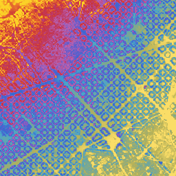
Google's Near-Global Elevation Models at 15m (GEM-15) is an experimental
(under review) near-global elevation dataset at 15m grid spacing derived
from sub-meter optical stereo satellite imagery. The dataset is built from
optical stereo imagery acquired through 2024 (primarily 2022--2024
30cm Pléiades Neo imagery, supplemented by WorldView-2/3/4,
GeoEye-1, Pléiades 1A/1B, and 1.5m SPOT stereo imagery), aggregating
native 0.5m DSM reconstructions and 1.0m DTM predictions to 15m resolution.
Alongside the primary 15m Digital Surface Model (`dsm`), GEM-15 includes
within-cell elevation percentiles (`dsm_percentile_5`, `dsm_percentile_50`,
`dsm_percentile_95`), sub-grid elevation standard deviation (`dsm_std`), and
a bare-earth Digital Terrain Model (`dtm`) predicted at 1.0m resolution
using a deep learning model prior to aggregation.
- Explore the elevation layers interactively through the [GEM-15 Earth Engine App](https://climate-and-sustainability.projects.earthengine.app/view/gem-15).
- Access the [Google Cloud Storage (GCS) COGs](https://storage.googleapis.com/climate-and-sustainability/gem-15) (`gs://climate-and-sustainability/gem-15`) and [STAC catalog](https://storage.googleapis.com/climate-and-sustainability/gem-15/stac/catalog.json).
- Find the evaluation code on [GitHub](https://github.com/google-research/google-research/tree/master/gem_15).
- Read the preprint on [EarthArXiv](https://eartharxiv.org/repository/view/16034/) ([doi:10.31223/X55N75](https://doi.org/10.31223/X55N75)).
All elevation layers report orthometric heights in meters referenced to the
EGM96 geoid vertical datum ([EPSG:5773](https://epsg.io/5773)) and are
projected in local UTM zones at 15m pixel resolution.
**Possible Uses:**
- **Flood and inundation modeling:** Using the 15m bare-earth `dtm` and `dsm` layers for watershed, flow and inundation modeling.
- **Canopy and building height estimation:** Combining `dsm_percentile_95` (or `dsm`) with `dtm` to estimate above-ground building and forest canopy heights (`dsm - dtm`) and local vertical variability (`dsm_std`). Note that super-tall (\~\>50m) buildings are often not captured well due to stereo limitations.
- **Topographic analysis:** Using the 15m elevation layers for satellite imagery orthorectification and slope or aspect calculation.
**Limitations:**
- **Multi-temporal imagery:** Tiles are constructed from multi-view imagery across three sensor tiers: 63.2% of mapped tiles use 2022--2024 30cm Pléiades Neo imagery, 24.4% use other sub-meter sensors (WorldView-2/3/4, GeoEye-1, Pléiades 1A/1B), and 12.4% use 1.5m SPOT imagery. Temporal transitions can appear along acquisition boundaries.
- **Coverage exclusions:** Coverage spans latitudes 60°S to 84°N and excludes Russia, China, Mongolia, Greenland, and Antarctica. India data is offset (with the offsets tapering off outside India's border over tens of kilometers) to comply with India Geospatial regulations.
- **Water masking and voids:** Water bodies (plus a 9m buffer), snow/ice, salt pans, and other low-texture surfaces (\~1--3% of cells), and pixels differing by more than 50m from Copernicus GLO-30 are masked as no-data.
- **Dense forest canopy:** Because the elevations are derived from optical stereo imagery rather than LiDAR, bare-earth `dtm` accuracy is lower in dense forests where the ground is not visible from above.
- **Absolute vertical accuracy:** Regional mean offsets of several meters relative to airborne lidar occur (-4.8 m to +1.9 m across the validation regions in the paper). Where absolute precision is critical, debias against local control.
### Bands
**Bands**
Pixel size: 15 meters (all bands)
| Name | Units | Pixel Size | Description |
|---|---|---|---|
| `dsm` | m | 15 meters | Digital Surface Model (mean of 2.5m bilinear native DSM within 15m cell) |
| `dsm_std` | m | 15 meters | Standard deviation of 2.5m bilinear native DSM within 15m cell |
| `dsm_percentile_5` | m | 15 meters | 5th percentile of 2.5m bilinear native DSM within 15m cell |
| `dsm_percentile_50` | m | 15 meters | 50th percentile (median) of 2.5m bilinear native DSM within 15m cell |
| `dsm_percentile_95` | m | 15 meters | 95th percentile of 2.5m bilinear native DSM within 15m cell |
| `dtm` | m | 15 meters | Bare-earth Digital Terrain Model (mean of 2.5m bilinear native DTM within 15m cell) |
### Terms of Use
**Terms of Use**
This dataset is licensed under
[CC-BY 4.0](https://creativecommons.org/licenses/by/4.0/) and requires the
following attribution: "This dataset is produced by Google".
### Citations
Citations:
- Batchu, V. V., Neumann, M., Li, T., Allen, B., Zhang, J., \& Van Arsdale, C.
(2026). GEM-15: Global surface and terrain elevation models (15 meters) from
sub-meter optical stereo imagery. EarthArXiv \[preprint\].
,
[doi:10.31223/X55N75](https://doi.org/10.31223/X55N75)
### DOIs
-
### Explore with Earth Engine
> [!NOTE]
> **Important:** Earth Engine is a platform for petabyte-scale scientific analysis and visualization of geospatial datasets, both for public benefit and for business and government users. Earth Engine is free to use for research, education, and nonprofit use. To get started, please [register for Earth Engine access.](https://console.cloud.google.com/earth-engine)
### Code Editor (JavaScript)
```javascript
// --- Cyclic Color Palette (256 steps) ---
var elevationPalette = [
'#f985f8', '#fa84f6', '#fb83f3', '#fc82f1', '#fc81ee', '#fd7feb', '#fd7ee8',
'#fd7ce5', '#fd7ae2', '#fd78de', '#fd76db', '#fc74d7', '#fc72d4', '#fb70d0',
'#fb6dcc', '#fa6bc8', '#fa69c5', '#f967c1', '#f864bd', '#f762bb', '#f75fb7',
'#f65db4', '#f55bae', '#f458aa', '#f356a6', '#f254a3', '#f1519f', '#f04f9b',
'#ef4c97', '#ee4a94', '#ed4890', '#ec468c', '#ea4388', '#e94184', '#e83f81',
'#e63d7d', '#e53b79', '#e33975', '#e13771', '#e0356a', '#de3366', '#dc3162',
'#da2f5e', '#d92d5a', '#d72c56', '#d52a52', '#d3284f', '#d1264b', '#cf2447',
'#cd2343', '#cb213f', '#ca1c3d', '#c81b39', '#c61935', '#c41832', '#c2172e',
'#c11727', '#bf1724', '#be1721', '#bd171e', '#bc181b', '#bb1919', '#ba1b16',
'#b91d14', '#b91f11', '#b9210f', '#b9230d', '#b9260c', '#b9290a', '#ba2b08',
'#ba2e07', '#bb3106', '#bc3306', '#bc3605', '#bd3905', '#be3b05', '#bf3e04',
'#c04104', '#c14304', '#c24604', '#c34804', '#c44b04', '#c54d04', '#c65004',
'#c75204', '#c85404', '#c95705', '#ca5905', '#cb5c05', '#cc5e05', '#cd6105',
'#cd6305', '#ce6505', '#cf6705', '#d06905', '#d16c05', '#d16f05', '#d27105',
'#d37305', '#d37505', '#d47705', '#d47a05', '#d57c04', '#d57e04', '#d68104',
'#d68304', '#d78504', '#d78704', '#d88904', '#d88b04', '#d98e04', '#d99005',
'#d99205', '#d99406', '#da9707', '#da9908', '#da9b0a', '#daa10d', '#d9a20f',
'#d9a412', '#d8a515', '#d8a718', '#d7a81c', '#d5a91f', '#d4aa23', '#d3ab27',
'#d1ac2b', '#cfae2f', '#cdb033', '#cbb137', '#c9b23b', '#c6b33f', '#c4b343',
'#c1b246', '#beb24a', '#bbb14e', '#b8b052', '#b5af55', '#b2ae59', '#afad5c',
'#acad5f', '#a8ac62', '#a5ab65', '#a1aa68', '#9dab6b', '#99a96e', '#95a871',
'#91a774', '#8da677', '#89a57a', '#84a47d', '#7fa280', '#7ba183', '#77a086',
'#729e89', '#6e9d8c', '#699c8f', '#639b92', '#5e9a95', '#599898', '#53979b',
'#4e969e', '#4894a1', '#4392a4', '#3d90a7', '#388eaa', '#328cad', '#2d8ab0',
'#2889b3', '#2387b6', '#1f85b9', '#1a83bc', '#1581bf', '#107fc2', '#0e7dc5',
'#0c7ac8', '#0a78cb', '#0975ce', '#0973d1', '#096fd4', '#096cd7', '#0969da',
'#0a66dd', '#0b63e0', '#0c60e3', '#0d5de6', '#0e5ae9', '#0f57ec', '#1154ef',
'#1251f2', '#144ef5', '#154bf8', '#1748fb', '#1946fd', '#1b44ff', '#1d42ff',
'#2040ff', '#223fff', '#253eff', '#283dff', '#2b3dff', '#2e3dff', '#313eff',
'#343fff', '#3740ff', '#3a41ff', '#3d43ff', '#4045ff', '#4347ff', '#4649ff',
'#494bff', '#4b4dff', '#4e4fff', '#5251ff', '#5553ff', '#5855ff', '#5b57ff',
'#5e59ff', '#615bff', '#635dff', '#665fff', '#6961ff', '#6c63ff', '#6f65ff',
'#7267ff', '#7569ff', '#786aff', '#7b6cff', '#7e6eff', '#8170ff', '#8471ff',
'#8773ff', '#8a75ff', '#8d76ff', '#9077ff', '#9378ff', '#9679ff', '#997aff',
'#9c7bff', '#a07cff', '#a37dff', '#a77eff', '#aa7fff', '#ae80ff', '#b180ff',
'#b581ff', '#b882ff', '#bc83ff', '#bf84ff', '#c284ff', '#c585ff', '#c885ff',
'#cb86ff', '#ce86ff', '#d186ff', '#d486ff', '#d786ff', '#da86ff', '#dd87ff',
'#e087ff', '#e287ff', '#e587ff', '#e886fe', '#ea86fd', '#ec86fc', '#ee86fb',
'#f086fa', '#f285f9'
];
// --- GEM-15 Collection & Elevation Bands ---
var gem15Collection = ee.ImageCollection(
'projects/climate-and-sustainability/assets/gem-15_v1');
var gemMosaic = gem15Collection.mosaic();
var dsm = gemMosaic.select('dsm');
var dtm = gemMosaic.select('dtm');
var dsm_50 = gemMosaic.select('dsm_percentile_50');
var dsm_5 = gemMosaic.select('dsm_percentile_5');
var dsm_95 = gemMosaic.select('dsm_percentile_95');
var dsm_std = gemMosaic.select('dsm_std');
// Structural Heightmap (nDSM)
var heightmap = dsm.subtract(dtm);
// --- Base Global DEMs ---
// They are all based on an EGM2008 geoid, whereas GEM-15 is based on EGM96,
// however the visual difference is minimal. Please perform a geoid correction
// for precise altimetric measurements.
var copernicusDem = ee.ImageCollection('COPERNICUS/DEM/GLO30_2024_1').mosaic().select('DEM');
var alosDem = ee.ImageCollection('JAXA/ALOS/AW3D30/V4_1').mosaic().select('DSM');
var nasadem = ee.Image('NASA/NASADEM_HGT/001').select('elevation');
// --- Cyclic Hillshade Visualization Helper ---
// Because GEM-15 tiles span multiple UTM zones, the mosaic does not retain a
// single native projection. Reproject to a metric grid at native resolution
// before computing hillshade.
function visualizeCyclic(image, cycleMax, nativeScale) {
cycleMax = cycleMax || 100;
nativeScale = nativeScale || 15;
var dem = image.select(0);
var cycle = ee.Image.constant(cycleMax);
var gridDem = dem.reproject({
crs: 'EPSG:3857',
scale: nativeScale
});
var cyclic = gridDem.mod(cycle).add(cycle).mod(cycle);
var rgb = cyclic.visualize({
min: 0,
max: cycleMax,
palette: elevationPalette
});
var hs = ee.Terrain.hillshade(gridDem)
.divide(255)
.multiply(0.6)
.add(0.4);
var hs3Band = ee.Image.cat([
hs.rename('vis-red'),
hs.rename('vis-green'),
hs.rename('vis-blue')
]);
return rgb.multiply(hs3Band).toByte();
}
// --- Viewport Setup ---
Map.setCenter(2.165, 41.395, 14);
// --- Map Layers ---
Map.addLayer(
visualizeCyclic(nasadem, 100, 30), {},
'NASADEM 30m (Cyclic 100m + Hillshade)', false);
Map.addLayer(
visualizeCyclic(alosDem, 100, 30), {},
'ALOS AW3D30 (Cyclic 100m + Hillshade)', false);
Map.addLayer(
visualizeCyclic(copernicusDem, 100, 30), {},
'Copernicus GLO-30 (Cyclic 100m + Hillshade)', true);
Map.addLayer(
visualizeCyclic(dtm, 100, 15), {},
'GEM-15 DTM (Cyclic 100m + Hillshade)', true);
Map.addLayer(
visualizeCyclic(dsm, 100, 15), {},
'GEM-15 DSM (Cyclic 100m + Hillshade)', true);
Map.addLayer(
visualizeCyclic(dsm_50, 100, 15), {},
'GEM-15 DSM 50th Percentile (Cyclic 100m + Hillshade)', false);
Map.addLayer(
visualizeCyclic(dsm_5, 100, 15), {},
'GEM-15 DSM 5th Percentile (Cyclic 100m + Hillshade)', false);
Map.addLayer(
visualizeCyclic(dsm_95, 100, 15), {},
'GEM-15 DSM 95th Percentile (Cyclic 100m + Hillshade)', false);
Map.addLayer(
visualizeCyclic(dsm_std, 100, 15), {},
'GEM-15 DSM Std (Cyclic 100m + Hillshade)', false);
Map.addLayer(
heightmap, {min: 0, max: 25, palette: ['white', 'darkgreen']},
'Heightmap (0-25m)', true);
```
[Open in Code Editor](https://code.earthengine.google.com/?scriptPath=Examples:Datasets/climate-and-sustainability/projects_climate-and-sustainability_assets_gem-15_v1) [GEM-15: Near-Global Surface and Terrain Elevation Models (15m) (Experimental)](https://developers.google.com/earth-engine/datasets/catalog/projects_climate-and-sustainability_assets_gem-15_v1.md.txt) Google's Near-Global Elevation Models at 15m (GEM-15) is an experimental (under review) near-global elevation dataset at 15m grid spacing derived from sub-meter optical stereo satellite imagery. The dataset is built from optical stereo imagery acquired through 2024 (primarily 2022--2024 30cm Pléiades Neo imagery, supplemented by WorldView-2/3/4, GeoEye-1, Pléiades 1A/1B, and ... projects/climate-and-sustainability/assets/gem-15_v1, climate-and-sustainability,dem,elevation,elevation-topography,google,height,ml,publisher-dataset,topography 2025-01-01T00:00:00Z/2025-01-01T00:00:00Z -61 -179 84 180 Google Earth Engine https://developers.google.com/earth-engine/datasets
- [https://doi.org/10.31223/X55N75](https://doi.org/https://research.google/)
- [https://doi.org/10.31223/X55N75](https://doi.org/https://developers.google.com/earth-engine/datasets/catalog/projects_climate-and-sustainability_assets_gem-15_v1)