- Dataset Availability
- 1999-06-30T00:00:00Z–2002-09-04T00:00:00Z
- Dataset Provider
- USGS
- Earth Engine Snippet
-
ee.ImageCollection("USGS/LIMA/SR") - Tags
Description
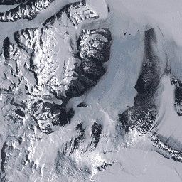
The Landsat Image Mosaic of Antarctica (LIMA) is a seamless and virtually cloudless mosaic created from processed Landsat 7 ETM+ scenes.
Processed Landsat Scenes (16 bit) are Level 1Gt NLAPS scenes converted to 16 bit, processed with sun-angle correction, and converted to reflectance values (Bindschadler 2008).
Each Landsat scene is processed with elevation data and sun-angle correction to ensure surface features were accurately represented. The sun's angle in Antarctica gives the appearance of a setting sun. Because of the low sun angle, as Landsat passes over Antarctica, the outer edges of the continent appear brighter than areas closer to the South Pole, so scenes have bright and dark areas. Inconsistent sun angles and shadows where corrected for these scenes. Without this process, mosaicking would produce a patchwork of scenes since each scene would have a brighter and a darker side.
Users can find individual image metadata available as a table at: USGS/LIMA/SR_METADATA
Bands
Bands
| Name | Pixel Size | Wavelength | Description |
|---|---|---|---|
B1 |
30 meters | 0.45 - 0.52 μm | Blue |
B2 |
30 meters | 0.52 - 0.60 μm | Green |
B3 |
30 meters | 0.63 - 0.69 μm | Red |
B4 |
30 meters | 0.77 - 0.90 μm | Near infrared |
B5 |
30 meters | 1.55 - 1.75 μm | Shortwave infrared 1 |
B7 |
30 meters | 2.08 - 2.35 μm | Shortwave infrared 2 |
B8 |
15 meters | 0.52 - 0.90 μm | Panchromatic |
Terms of Use
Terms of Use
These images are in the public domain and can be used freely and without acknowledgement. However, credit to the Landsat Image Mosaic of Antarctica (LIMA) Project is greatly appreciated.
Citations
Bindschadler, R., Vornberger, P., Fleming, A., Fox, A., Mullins, J., Binnie, D., Paulson, S., Granneman, B., and Gorodetzky, D., 2008, The Landsat Image Mosaic of Antarctica, Remote Sensing of Environment, 112, pp. 4214-4226. PDF
Explore with Earth Engine
Code Editor (JavaScript)
var dataset = ee.ImageCollection('USGS/LIMA/SR');
var antarctica = dataset.select(['B3', 'B2', 'B1']);
var antarcticaVis = {
  min: 0.0,
  max: 10000.0,
};
Map.setCenter(164.619, -77.99, 7);
Map.addLayer(antarctica, antarcticaVis, 'Antartica Imagery (RGB)');